
March 21, 2023
Expanding the Role of GNSS in Seismic Monitoring
Identifying seismic signals in GNSS reference stations using machine learning.
By Inside GNSSGlobal Navigation Satellite Systems Engineering, Policy, and Design
Identifying seismic signals in GNSS reference stations using machine learning.
By Inside GNSS
In the wake of the latest COP session on international climate change, and as the world continues to deal with the effects of a warming planet, researchers say more and better data can help ameliorate the damage and provide answers on how to respond to it.
By Brett Davis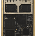
Hemisphere GNSS’s new Vega 34 OEM heading and positioning board enables users to upgrade to multi-frequency GNSS without changing pinouts. Integrators who use predecessor Hemisphere 34-pin products such as Crescent Vector H220 and Phantom 34 OEM boards can now transition to improved positioning performance and satellite tracking capabilities of the Vega series.
By Inside GNSS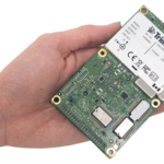
Applanix announced its Trimble AP+ Land GNSS-inertial OEM solution for accurate and robust position and orientation for georeferencing sensors and positioning vehicles in land mobile mapping applications. It enables users to accurately and efficiently track and monitor fleets, produce high-definition (HD) maps and 3D models, or act as a reference solution for advanced driver-assistance systems (ADAS) testing, even in challenging GNSS environments.
By Inside GNSS
By Miguel Amor, Chief Marketing Officer
Hexagon’s Autonomy & Positioning division
I had my first interaction with a geodetic GPS receiver in the early ’90s. In my freshman year of college, a professor demonstrated how to use two single-frequency receivers to achieve centimeter accuracy for post-processing observations. I didn’t know at the time that I would spend the next 30 years deeply involved in and contributing to this innovative positioning technology.
By Inside GNSS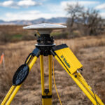
Trimble has introduced the R750 GNSS modular receiver, a connected base station for use in civil construction, geospatial and agricultural applications. The R750 provides improved base station performance, giving contractors, surveyors and farmers reliable and precise positioning in the field.
By Inside GNSS
Trimble has rolled out the latest version of its core geospatial automated monitoring software, Trimble 4D Control version 6.3. The software provides automated movement detection to enable informed decisions about infrastructure for surveying, construction and monitoring professionals.
By Inside GNSS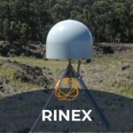
The RINEX Working Group of the International GNSS Service (IGS) has released the new Receiver Independent Exchange Format Version 4.00 (RINEX4), as of December 1, 2021.
By Inside GNSS
Join Adam Barnes, Head of Product at Advanced Navigation, and Ashley Cox, Chief Operating Officer at Cordel, to find out how the latest LiDAR and navigation technologies are revolutionizing surveying.
In this webinar, Adam and Ashley will deep-dive into LiDAR surveying and explain how Cordel leveraged innovative technology to push the boundaries of the industry. They will cover the challenges in UAV-based surveying, in balancing cost and altitude restrictions, with LiDAR point density and INS accuracy to achieve the best overall solution.
By Inside GNSS
Representatives from 50 African countries attended the first China-Africa BeiDou Navigation Satellite System, held in Beijing on November 5, organized by the China Satellite Navigation Office (CSNO) and a department of the African Union Commission.
By Inside GNSS
Trimble launched its DA2 GNSS receiver for the Trimble Catalyst positioning service. The DA2 second-generation receiver and antenna for the Catalyst service now includes the Trimble ProPoint GNSS engine
By Inside GNSS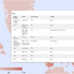
The European Union Agency for the Space Programme (EUSPA) has published an online interactive world map providing information about augmentation service providers that support Galileo. Clicking over each country shows the names of the Galileo-ready providers along with the name of the service, type of service and coverage.
By Inside GNSS
Russia’s state space agency Roscosmos will start placing ground stations for its GLONASS navigation satellite system across China, tentatively before the end of the year, announced Roscosmos Deputy Director for International Cooperation General Sergey Saveliev.
By Inside GNSS