How GEODNET’s blockchain-based decentralized network approach is scaling global GNSS correction network density and coverage.
MIKE HORTON, GEODNET
Modern multi-band multi-constellation receivers almost universally support Real-Time Kinematic (RTK) measurement processing and easily achieve centimeter-level position accuracy when used in RTK modes. To enable RTK positioning on a GNSS receiver requires a source of GNSS corrections typically streamed from a GNSS correction service provider. The service provider in turn needs observation data from one or ideally several well-installed local GNSS reference stations to process and transmit a localized RTK correction stream.
Given modern GNSS RTK receivers are ubiquitous, easy-to-use and available at ever lower-costs, the question is: How many stations and how much cost is involved in building a global scale RTK corrections network?
Station Count for a Truly Global RTK Network
The closer reference stations are located to the user’s RTK receiver, the more accurate, fast and reliable the final RTK fix position result. The traditional rule of thumb for RTK position accuracy is 1 centimeter accuracy up to 10 kilometers from the station. Virtual reference station (VRS) software fuses multiple reference stations into a Network RTK stream, improving accuracy and robustness in comparison to a single station solution. Network RTK can provide centimeter accuracy at average distances of 20 kilometers from a set of reference stations. Therefore, one reliable, well installed reference station per 10 to 20 km is the ideal geometric spacing for an RTK network.
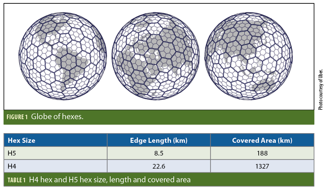
To estimate how many stations are needed to achieve this density, GEODNET, a blockchain-based decentralized network of high-precision multi-band GNSS base stations, has chosen to organize its station maps into hexes following the H3 hex standard developed and open-sourced by Uber. GEODNET uses the H4 hex and H5 hex to analyze coverage and robustness.
The land masses of the Earth’s various continents as well as an approximate number of contained hexes is shown in Tabel 2. Indeed, the Earth is big.
To build out a more than 100,000-station network using a traditional station deployment model requires massive up-front and recurring investment. The investment needed would be on the same scale as developing a full nationwide 4G network—billions of dollars and beyond. As a result, the largest RTK networks in service today comprise 4,000 to 5,000 stations, a small percentage of the full coverage numbers. The coverage gaps lead to reduced sales and use of RTK-based workflows and reduced field productivity. Even in highly developed countries such as the United States, there is no GNSS network or correction provider that provides full RTK accuracy in all populated regions.
Today’s Solutions: Compromises and Complexity
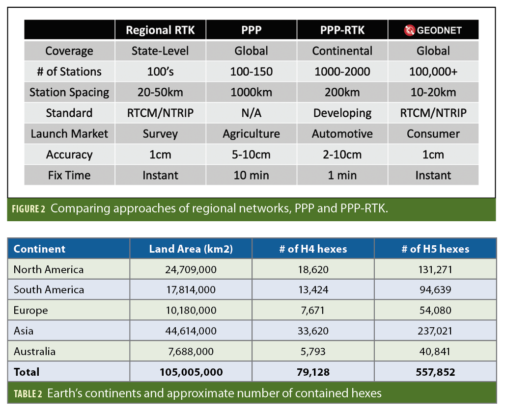
To reduce the financial burden of deploying and managing a massive network of GNSS reference stations, leading companies and institutions in the GNSS industry have taken alternative approaches to provide GNSS corrections. These approaches include smaller regional networks, Precise Point Positioning (PPP) networks and PPP-RTK services. These are all practical solutions for various markets and geographies but fall short of an Internet like standardized experience that a true global RTK network could provide.
Here’s a summary of each approach:
Regional Networks
Many countries and most states in the United States have set up regional RTK correction networks. Because of limited budgets, most of these networks haven’t been upgraded to fully modernized four-constellation triple-band receivers, and the number of stations available is typically static year to year. Each network has its own account creation process, login method and fees (a few are free). This makes it difficult for devices to ship pre-configured for RTK service and to move between regions. Lack of full-constellation full-band data limits the performance and reliability achievable with a modern user receiver.
On the positive side, regional RTK networks typically are intended for true RTK use and transmit data in
standardized RTCM formats. This ensures a high degree of compatibility with user equipment.
PPP and PPP-RTK Networks
To provide large continental and global-scale coverage, several large GNSS companies have developed PPP and PPP-RTK networks as well as PPP and PPP-RTK compatible GNSS receivers. Traditional PPP requires approximately 100 geodetic reference stations deployed evenly over the Earth’s surface. Remote locations such as the Aleutian Islands and South Pacific Islands are frequently home to PPP stations. Data from these stations is used to model each satellite’s clock and orbit errors, and this data is encoded and transmitted to the GNSS receiver in the field via a manufacturer specific L-band signal. PPP-RTK pulls additional station data from regional receivers to generate better ionospheric corrections. PPP-RTK requires hundreds to a few thousand stations, but still far less than traditional RTK for a comparable coverage area. The lower station density approaches offer advantages in terms of total infrastructure cost while still providing broad area coverage.
Performance disadvantages include reduced accuracy, longer convergence times, and reduced ability to handle high-ionospheric activity. All these disadvantages come from compromises made for larger station separation. Another disadvantage is commercial PPP and PPP-RTK solutions are not cross-compatible among receiver brands. Instead, they typically rely on the PPP or PPP-RTK provider’s positioning engine. Many low-end GNSS receivers do not support PPP or PPP-RTK without modification.
The GEODNET Network: A Different Approach
The non-profit GEODNET Foundation uses a decentralized blockchain-based deployment strategy to promote developing a massive “Internet” of GNSS reference stations. GEODNET’s mission statement is “Building the World’s Largest RTK Network.”
The GEODNET Foundation established a protocol for the permissionless addition of verified stations to its network. The GEODNET protocol is intended to encourage global, scalable and capital efficient GNSS reference station deployments. GEODNET’s approach allows individuals as well as businesses to purchase and set up certified reference stations and add them to the GEODNET network. The protocol then compensates the station hosts based on their station’s quality, reliability and location. The compensation is in the form of GEOD token distributions, the project’s native cryptocurrency token. GEOD is transferrable to dollars or other fiat currencies using a combination of decentralized and centralized exchanges. There is a growing list of more than 7,000 wallet addresses holding the GEOD token worldwide. The process of earning GEOD tokens is referred to as Satellite Mining or Space Weather Mining.
The GEODNET Foundation is a Singapore non-profit organization that seeks to connect satellite miners with paid high-precision GNSS OEMs and data resellers. When GEODNET receives fees for station access, 80% of the fees are used to repurchase GEOD tokens from the open market and remove them from circulation. This token buy-back and burn mechanism supports miners who want to sell their tokens. The remaining 20% supports the foundation’s organizational costs.
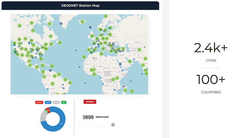
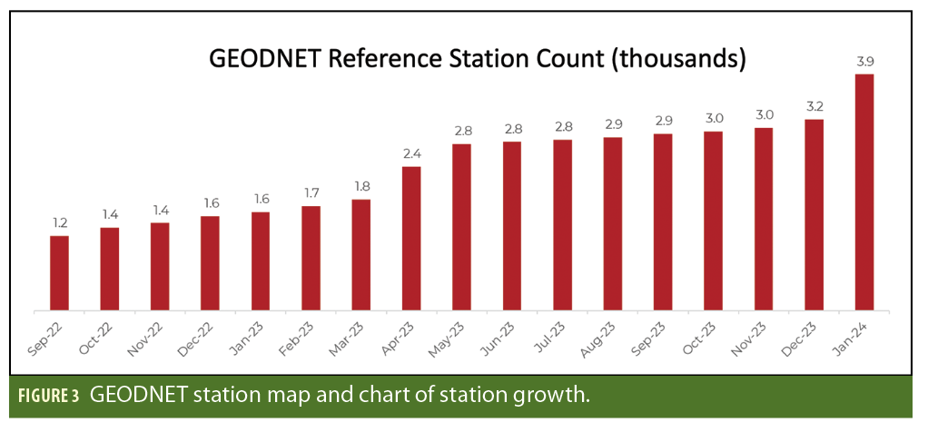
In the web3 blockchain industry, GEODNET is known as a Decentralized Physical Infrastructure Network (DePIN). Other DePIN networks include projects for low-rate wireless networks, WiFi roaming networks, mapping and environmental sensing. GEODNET’s growth is rapid with more than 3,000 stations operating stably and an average of 60 stations added weekly. DePIN is reported as one of the top trends in blockchain and cryptocurrency.
Besides encouraging rapid station count growth and open access to the network, a decentralized GNSS network provides additional benefits. Decentralization allows participants in the GNSS ecosystem to create branded GEODNET versions, set their own network fees, and accommodate customers specific business needs for RTK. At the same time, they can own a piece of the broader network upside via GEOD token ownership. GNSS companies and OEMs can access bulk raw data to develop their own PPP, PPP-RTK or RTK services. Dealers can resell the standard GEODNET RTK service under a 50/50 revenue share model with the GEODNET Foundation. Customers who deploy stations can mine the token while simultaneously benefiting from the network. The larger the network grows, the more customers use it—driving GEOD token repurchase and burning, increasing the value. This in turn encourages more people and institutions to add stations. This growth flywheel is known as the Network Effect, and GEODNET benefits strongly from it.
Conclusion
DePIN is a new concept for scaling networks. GEODNET is the largest DePIN network for RTK corrections. DePIN provides the potential for a large network, lower costs and more open access. DePIN based networks use newer technology, and time will tell their true impact on the GNSS industry.
Author
As a successful entrepreneur, Mike Horton, GEODNET project creator, is the CTO and Co-Founder of ANELLO Photonics. Prior to ANELLO, he co-founded Crossbow Technology in 1995 and served as CEO until it was sold to Moog Inc. in 2011. He earned a BS/MS in Electric Engineering from UC Berkeley.


