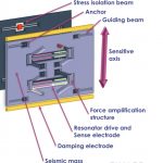
MEMS has moved into the high-end market, and the latest disruptor to take into account is silicon MEMS. That’s micro-electromechanical systems based in silicon chips, for short. Accelerometers with up to 100g range and 70µg bias in a very small form factor — 6 cubic centimeters — are exploding the horizons for inertial applications.
The China Satellite Navigation Office (CSNO) announced completion of two years of testing of BeiDou inter-satellite links, an innovative feature of the GNSS that will reportedly produce greater accuracy for users on Earth. The test campaign encompassed 29 satellites of the third generation (BDS-3) of the now global system.
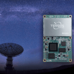
Tersus GNSS has released the BX40C RTK Board to support its series of GNSS boards and provide high-accuracy, fast positioning services. Powered by new Tersus ExtremeRTK GNSS technology, the BX40C Board can support multi-constellation and multi-frequency all-in-view satellite tracking.
A great man has left us, left the international GNSS community. Dr. Javad Ashjaee passed away in Moscow on May 30 from the corona virus illness, a family member reported on social media.
A new marine-certified quad-band GNSS receiver, the LD900 from VERIPOS, delivers accurate and reliable positioning in demanding offshore environments. The LD900 can track four GNSS frequencies simultaneously to ensure a precise position is always available at sea.
The MEMS-based inertial measurement unit (IMU) represents the single biggest positioning and navigation advance of the last 20 years. That assertion is made during the first of three panels in the webinar “Inertial Technology for Robotics, UAVs and other Applications,” freely available on May 6. The 1.5 hour presentation examines how this breakthrough plays in the fields of autonomy, high dynamics and challenging environments, including on the frontiers of space.
Three experts takes a close-up look at contemporary and emerging inertial sensor technologies and applications, from the laboratory to the factory to the field. Register here to attend. The webinar is sponsored by Sensonor.
MEMS (micro-electromechanical sensors) make possible a miniaturization of size, weight, power requirements and cost never thought achievable before. When MEMS inertial navigation pairs with GPS for navigation, the key factor is the error budget of each sensor and how that plays into the accuracy of the solution. Attendees will learn how the new inertial sensors’ reduced error budgets translate into higher system performance.
The presentation begins with the current state of the inertial art, delivered by a recognized expert. The second speaker describes a high-accuracy tactical-grade inertial measurement unit (IMU) with increased accelerometer performance to support demanding guidance and navigation applications.
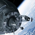
This knowledge is taken to the field to examine the IMU’s role in successful satellite launch missions during the third panel. The attitude determination and control system (ADCS) rises to the challenge of an extremely demanding environments and set of requirements. A satellite moving at a speed of 7,500 meters/second over ground requires precise maneuvering, stabilization and point in order to obtain imagery at 1-meter resolution.
Questions from the audience are actively encouraged and will be addressed by the three speakers in the final portion of the webinar.
Webinar speakers:
Ralph Hopkins, Draper Lab
Ralph Hopkins is a Distinguished Member of the Technical Staff and Group Leader in the Positioning Navigation and Timing (PNT) Division at Draper, a leading research & development organization. He is responsible for the design and development of inertial instruments and sensors. Ralph has served as Technical Director of advanced inertial instrument development programs including strategic, navigation and tactical grade gyroscopes and accelerometers. He holds an ME in Engineering Mechanics from Columbia University, and an MS in Engineering Management from The Gordon Institute of Tufts University.
Reidar Holm, Sensonor
Reidar Holm is a Product Development Manager at Sensonor, a producer and developer of high-precision, light-weight gyros and IMUs. He works MEMS R&D and design, ASIC design, low-stress package design, system design, assembly and calibration, and high-volume production for automotive, MEMS pressure sensors, accelerometers, gyros and IMUs. He has a Degree in Electrical Engineering and Electronics from University of Manchester Institute for Science and Technology (UK) in 1982.
Ryan Robinson, LeoStella
Ryan Robinson is the Lead Guidance, Navigation and Control Engineer at LeoStella, a small satellite design and manufacturing company, He is responsible for the design, development, test, and delivery of ADCS subsystems on LeoStella satellites. He received a Ph.D. in Aerospace Engineering from the University of Maryland, College Park. Technical areas of interest include attitude determination and control systems design, sensing and actuation, nonlinear dynamics, and autonomy.
Register here for the free webinar, “Inertial Technology for Robotics, UAVs and other Applications.” The webinar will also be available for subsequent download, for those registrants unable to attend at the appointed time.
A new API for GNSS simulators enables greater accuracy, integrity and control for growing sensor-fusion testing needs. Spirent Communications’ SimHIL, an integrated hardware-in-the-loop (HIL) testing software API for Spirent GNSS simulators, brings high-fidelity GNSS signal simulation with low latency to automotive industry HIL testbeds.
EMCORE Corporation, a provider of advanced mixed-signal products serving the aerospace, defense and broadband communications markets, received the 2019 Raytheon Integrated Defense Systems (IDS) 5-Star Supplier Excellence Award for performance and partnership.
That aside, some controversy has arisen in the world of competitive running, and self-competitive running as in Personal Bests, or PBs. Runners find their fitness trackers and watches don’t necessarily tell them the truth in terms of distance travelled. In fact, they very rarely tell the absolute truth. Which matters.
Swift Navigation and Deutsche Telekom announced a partnership to incorporate Swift’s Skylark Cloud Corrections Services within Telekom’s communications infrastructure through its new Precise Positioning product offering. The companies’ joint lane-level accurate Precise Positioning is designed for level 2 and 3 automotive applications
Septentrio introduced a new compact and robust integrated heading GPS/GNSS receiver, the AsteRx SB ProDirect. It delivers accurate heading and pitch or heading and roll information in addition to reliable high-accuracy RTK positioning, according to the company.
Sapcorda Services GmbH announced the release of its Safe And Precise Augmentation (SAPA) Premium GNSS positioning service, providing GNSS corrections via internet and satellite.
Septentrio and Analog Devices now combine their technology specialties, multi-frequency multi-constellation GNSS receivers and high-quality inertial measurement units (IMUs), respectively, to deliver centimeter-accurate positioning with 3D orientation (heading, pitch and roll), for applications such as automotive advanced driver assistance systems (ADAS) and industrial automation.
There’s still time, barely, to sign up for this week’s webinar. Learn 3 key concepts for autonomous automotivery: lane level, antenna phase center offset and phase center variation.
An innovative positioning engine based on a safety-oriented paradigm uses a dual-frequency GNSS receiver, automotive cameras, accurate maps, low-cost inertial sensors and vehicle odometry. The real-time integrity layer bounds the error of each estimated value with a confidence level for safe navigation.