Main Categories

[uam_ad id="183541"]

Applanix Releases Updated POS for Land Vehicles

Applanix recently released Version 5 of its Position and Orientation System for Land Vehicles (POS LV).

According to the company, the system uses integrated inertial technology and is designed to generate stable, reliable and repeatable positioning solutions for land-based vehicle applications such as road geometry, pavement inspection, GIS database and asset management, road surveying and vehicle dynamics. The company says the unit is designed to operate under the most difficult GPS conditions in urban and suburban environments.

Read More >

By Inside GNSS
August 24, 2010

CDR Passed: GPS III Ready for Build Phase

Artist’s rendering of GPS III satellite. Lockheed Martin image

More than two years into a multi-billion-dollar contract, the Lockheed Martin team developing the U.S. Air Force’s next-generation GPS Block III satellites continues to defy the physics of large aerospace programs by successfully completing the program’s Critical Design Review (CDR) phase last week — two months ahead of the baseline schedule.

Read More >

By Inside GNSS
August 19, 2010

Air Force Approves 3 GPS Technical Specs

The GPS Wing has authorized publication of three technical documents with updated specifications for the U.S. Global Positioning System, including the next-generation GPS Block IIIA satellites now in development, the L5 radio link, and the new L1 civil signal  (L1C) that will be available with the GPS III spacecraft.

Read More >

By Inside GNSS
[uam_ad id="183541"]
August 17, 2010

A Search for Spectrum

In recent years, researchers have explored possible new allocations for Radio Determination Satellite Service (RDSS) and Radio Navigation Satellite Service (RNSS) spectrum from a regulatory point of view. These studies have mainly discussed S-band and C-band in addition to L-band.

The International Telecommunications Union (ITU) Radio Regulations define RNSS as a subset of RDSS. Although the allocations are differentiated — RDSS usually has a paired uplink — both can actually be used for satellite navigation.

Read More >

By Inside GNSS

A Fully Digital Model for Kalman Filters

Q: Is it possible to define a fully digital state model for Kalman filtering?

A: The Kalman filter is a mathematical method, purpose of which is to process noisy measurements in order to obtain an estimate of some relevant parameters of a system. It represents a valuable tool in the GNSS area, with some of its main applications related to the computation of the user position/velocity/time (PVT) solution and to the integration of GNSS receivers with an inertial navigation system (INS) or other sensors.

Read More >

By Inside GNSS

GPS IIF-1 Satellite

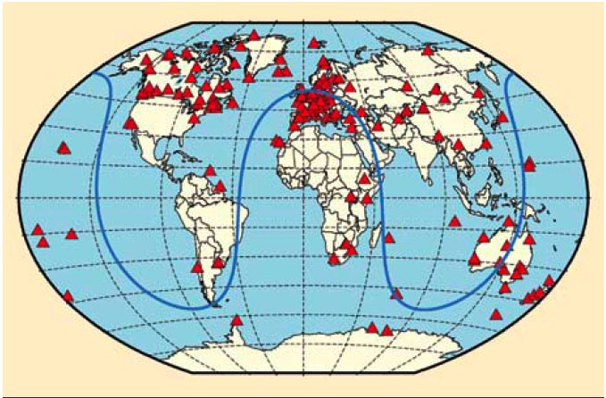
FIGURE 1: Geographical overview of the 170 IGS stations tracking SVN62/PRN25 during its current 90-day checkout period. The blue curve illustrates the ground track of the spacecraft on August 9, 2010.

For the complete story, including figures, graphs, and images, please download the PDF of the article, above.

On May 27, 2010, the U.S. Air Force successfully launched the first satellite of the Block II “follow-on” (Block IIF) series, the fourth generation of GPS spacecraft that features more precise and powerful signals, an extended design life, and several other technical advances.

Read More >

By Inside GNSS
August 14, 2010

Map Africa 2010

Map Africa 2010 conference and exhibition will take place at the Cape Town International Convention Centre (CTICC) in the center of Cape Town, South Africa on November 23-25, 2010.

The theme is "Geospatial Readiness for Building Africa." The conference will focus on the most pressing areas that contribute to the nation’s growth, such as infrastructure and utilities, cadastral mapping, land information management system (LIS), land policies, mining and exploration and emergency management.

Read More >

By Inside GNSS

EIWAC 2010: 2nd ENRI Workshop on ATM/CNS

Japan’s Electronic Navigation Research Institute (ENRI) will present the second workshop on Communications, Navigation and Surveillance Systems for Air Traffic Management at the Akihabara Convention Hall in Tokyo on November 11 and 12, 2010.

Registration will close on October 30, 2010.

The theme is ForeSEE: Safety, Efficiency and Environment. The conference is free and will be held in English.

Read More >

By Inside GNSS
IGM_e-news_subscribe