Main Categories

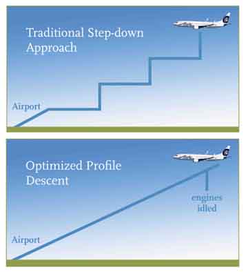
China Approves License for 18 Mapping Services — AutoNavi Included, Google Unlikely Choice

[Reprinted with permission from NAVIBIZ, Issue Date: 2010-7-2]

Late in May, China implemented new standards aimed at preventing "state secrets being disclosed and uncertified maps published online." A major component to this push was a requirement that all online mapping services are operated with a license. The first 18 companies, of the ones that applied for a license, have been approved.

Read More >

By Inside GNSS

Latest Updates on Satellite Navigation — Only at NaviForum Shanghai 2010

[Reprinted with permission from NAVIBIZ, Issue Date: 2010-7-23]

On June 2, China successfully launched the fourth BeiDou navigation satellite into the pre-designated orbit, symbolizing that China has made another important step forward in building the BeiDou (COMPASS) Navigation Satellite System. As is known to all, satellite navigation and positioning system is the key strategic infrastructure for information, and it will influence the process of social civilization and change people’s ideas about life, time and space.

Read More >

By Inside GNSS

GPS-Aided Test Flight Lowers Emissions by 35 Percent in Alaska Airlines “Greener Skies” Project

Alaska Air graphic

Alaska Airlines demonstrated next-generation GPS-aided flight procedures last week (July 23) during a test flight over Puget Sound, Washington, that burned less fuel and reduced emissions by 35 percent compared to a conventional landing.

The flight was part of Alaska Air Group’s “Greener Skies” project at Seattle-Tacoma International Airport (Sea-Tac) focused on using satellite-based guidance technology to fly more efficient landing procedures that will reduce environmental impacts in the region.

Read More >

By Inside GNSS
[uam_ad id="183541"]
July 27, 2010

GNSS Simulators

FIGURE 1: GNSS multi-channel signal simulator 10 years ago on its own (left) and with its ever-growing family (right)

For the complete story, including figures, graphs, and images, please download the PDF of the article, above.

In this article we describe the design and operation of a generic GNSS RF simulator. We also will look at the main types of GNSS RF simulators, their designs and specifics, their advantages and disadvantages.

Read More >

By Inside GNSS

Meet GINA

GINA On-Board Unit (OBU)

For at least the past two decades, managing traffic on Europe’s road networks has been a growing concern for European policy makers and citizens alike. While demand for transport has consistently increased over the years, Europe’s road network capacity has failed to keep pace, leading to increasing levels of congestion and pollution.

Read More >

By Inside GNSS

Help from Above

During flight testing, Boeing technical personnel have historically used a differential GPS (DGPS) system as the position truth reference for validating various production systems on the airplane. The majority of those tests occur on or near remote runways to capture specific environmental conditions.

Read More >

By Inside GNSS
[uam_ad id="183541"]
July 22, 2010

Topcon Promotes O’Connor to Managing Executive Officer

Ray O’Connor, Topcon Positioning Systems

Topcon Corporation has announced the promotion of Ray O’Connor to managing executive officer for the company.  

O’Connor is president and CEO of Topcon Positioning Systems (TPS), based in Livermore, California, and chairman of the board of Topcon Europe Positioning. He will continue to fill these and other positions within the corporation while taking on additional managerial oversight of various corporate projects and initiatives.

Read More >

By Inside GNSS
July 21, 2010

Interesting. Too Interesting?

In the world of GNSS we usually think of more as better. More systems, more satellites, more signals — all contribute to greater availability of robust positioning, navigation, and timing.

Certainly that was the mood at the June meeting of the Asia-Pacific Economic Cooperation — GNSS Implementation Team (APEC-GIT) in Seattle, Washington.

Read More >

By Inside GNSS
July 19, 2010

Air Force Investigating Residuals in GPS IIF Signals

GPS IIF-SV1 launch. United Launch Alliance photo

[Updated July 22, 2010] Air Force officials at the GPS Wing have confirmed that higher-the-expected range residuals detected by researchers at the German Aerospace Center (DLR) are appearing in signals transmitted by the first GPS IIF satellite, designated SVN/62/PRN25.

But the Air Force and Boeing Space and Intelligence Systems, which built the spacecraft, point out SVN62 is currently performing within specifications, and the signal phenomenon does not appear likely to have any significant effect on GPS positioning when the satellite is declared operational.

Read More >

By Inside GNSS
July 16, 2010

Lockheed Martin Unveils GPS Exhibit at the United Nations in Vienna

Rick Ambrose, Lockheed Martin vice-president and general manager, surveillance and navigation systems, introduces GPS Block III model for Permanent Space Exhibit at United Nations Committee on Pea, Vienna,

Lockheed Martin has opened a GPS exhibit as a part of the Permanent Space Exhibit of the United Nations Office at Vienna, Austria, to emphasize the importance of satellite navigation technology serving millions of citizens around the globe.

Read More >

By Inside GNSS
July 14, 2010

Royal Institute of Navigation NAV10 Conference

Convocation Hall, Church House

The theme of NAV10 is "Position, Location, Timing: Everyone, Everything, Everywhere

The international Royal Insitute of Navigation conference will take place from November 30 to December 2 at Church House, Westminster, London.

The event attracts users and specialists in all areas of navigation. It will run as two parallel sessions over three days and will cover all major applications including marine, aerospace and ground vehicle navigation.

Read More >

By Inside GNSS
IGM_e-news_subscribe