
Hemisphere GPS has signed a multi-year exclusive agreement to supply the S3-S Navigator — a customized Outback S3 precision guidance system — for Summit Liability Solutions. Both companies are based in Calgary, Alberta, Canada.
Hemisphere GPS has signed a multi-year exclusive agreement to supply the S3-S Navigator — a customized Outback S3 precision guidance system — for Summit Liability Solutions. Both companies are based in Calgary, Alberta, Canada.
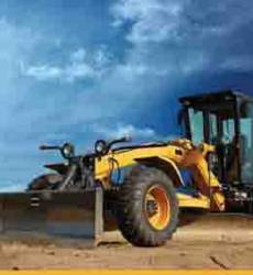
Hemisphere GPS has also announced the release of the Earthworks X300 excavator guidance system. Integrating Hemisphere GPS’ patented Crescent Vector GPS compass technology, X300 is designed to improve excavation proficiency and accuracy by measuring and displaying three-dimensional excavator positioning to machine operators.
The S3-S Navigator uses Hemisphere GPS’ Crescent GPS receiver technology in combination with its DriveTC for tilt control to precisely apply drilling fluids to a disposal area. The company says it is designed to eliminate most of the human error in drilling waste disposal services.
With Summit’s direction and logic, Hemisphere GPS modified the Outback S3 to interface with the Summit Earth system, a web-based data entry platform with built-in satellite imagery, regulatory compliance checking and self-auditing capabilities and reporting functionality. Spatial information from Summit Earth is uploaded into the S3-S Navigator and, once armed, the system controls the discharge valve of a disposal unit based on regulatory parameters entered by Summit’s field technicians,.
The S3-S Navigator’s software provides visual reference and guidance of the disposal operations. Upon job completion, spatial information collected in real time is downloaded from the S3-S Navigator and uploaded into Summit Earth, where the final report is produced and the disposal area is overlaid onto satellite imagery.
The S3-S Navigator provides on/off boundaries to keep waste disposal within a defined area and automatically turns the discharge system on and off when the vehicle reaches the set boundaries. The eDriveTC provides the S3-S Navigator with details of the vehicle’s slope to prevent runoff and pooling of drilling fluids by limiting disposal on restricted terrain and enables either pitch or roll measurements to be taken. The system is designed to convert log files into useable file formats for use in Summit Earth and Google Maps.


