Three different low-cost sensor integrations, covering vehicle navigation in a range of environments, will be covered in a February 12 webinar, “Automotive-Grade GNSS + Inertial for Robust Navigation.”
Global Navigation Satellite Systems Engineering, Policy, and Design
Three different low-cost sensor integrations, covering vehicle navigation in a range of environments, will be covered in a February 12 webinar, “Automotive-Grade GNSS + Inertial for Robust Navigation.”

Sapcorda Services GmbH announced the release of its Safe And Precise Augmentation (SAPA) Premium GNSS positioning service, providing GNSS corrections via internet and satellite.
By Inside GNSS
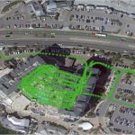
A new cloud-based, digital reality visualization platform in the Hexagon AB booth captured the attention of CES 2020 visitors in Las Vegas this week. HxDR creates accurate digital representations of the real world through the seamless combination of reality-capture data from airborne, ground and mobile sensors.
By Inside GNSS
There’s still time, barely, to sign up for this week’s webinar. Learn 3 key concepts for autonomous automotivery: lane level, antenna phase center offset and phase center variation.
By Inside GNSS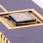
Draper has advanced its development of a LiDAR-on-a-chip using patented, all-digital MEMS optical switches for light beamsteering to gather the digital data to build high-definition maps.
By Inside GNSS
Calling all automotive engineers — and anyone involved in designing or promulgating the fast-oncoming world of autonomous driving.
For driverless vehicles, current GNSS meter-level positioning accuracy still serves for lane-level detection. But hazardous misleading information poses a serious, disruptive and critical safety concern.
By Inside GNSS
An innovative positioning engine based on a safety-oriented paradigm uses a dual-frequency GNSS receiver, automotive cameras, accurate maps, low-cost inertial sensors and vehicle odometry. The real-time integrity layer bounds the error of each estimated value with a confidence level for safe navigation.
By Inside GNSS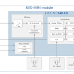
u‑blox released the NEO‑M9N, the first module based on the company’s new robust meter‑level M9 global positioning technology platform, designed for demanding automotive, telematics, and UAV applications.
By Inside GNSS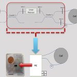
The complex and mission-critical needs of the autonomous vehicle market demand innovation at higher levels in several different sensors and in sensor integration. A new photonic chip technology offers promise in providing high-volume, low-cost manufacture of high-end, tactical-grade performance fiber-optic gyros (FOGs)for inertial navigation in GNSS-obstructed environments.
By Inside GNSSThis year’s Intelligent Transport Systems & Services (ITS) conference will be held in Denmark in September. ITS World Congress will take place from September 17-21 at the Bella Center in Copenhagen. The Congress Theme: “ITS – Quality of Life”, supports the Copenhagen belief that intelligent transport systems are an important means to enhance people’s daily lives through seamless, smart and sustainable mobility solutions.
By Inside GNSS
The Technology Roadshow continued its steady roll around North America building on Topcon’s Intersection of Infrastructure and Technology message. Along the 28-city tour, the traveling trailer stopped for several days in beautiful Pleasanton, California, just down the road from Topcon Positioning Systems’ headquarters in Livermore.
From the start, this four-day event, hosted by RDO Integrated Controls, Engineering Supply, Papé Machinery and 5D Solutions, provided attendees with a little extra insight into the potential of technology-enabled construction in infrastructure.
By Inside GNSS
Commercial UAV Expo Europe, presented by Commercial UAV News, is a conference and exhibition exclusively focused on commercial UAV integration and operation for large enterprise, industrial users. The event, April 10-12, 2018 in
By Inside GNSSRewire Security recently announced its GNSS enabled real-time GPS Tracker solutions for motorcycles. DB1-Lite from Rewire Security offers worldwide coverage, geo-fence zones, GNSS-enabled worldwide improved location accuracy and comes with a compact and durable design. It’s designed to be an optimal GPS tracking solution for motorcycles and cars.
By Inside GNSS