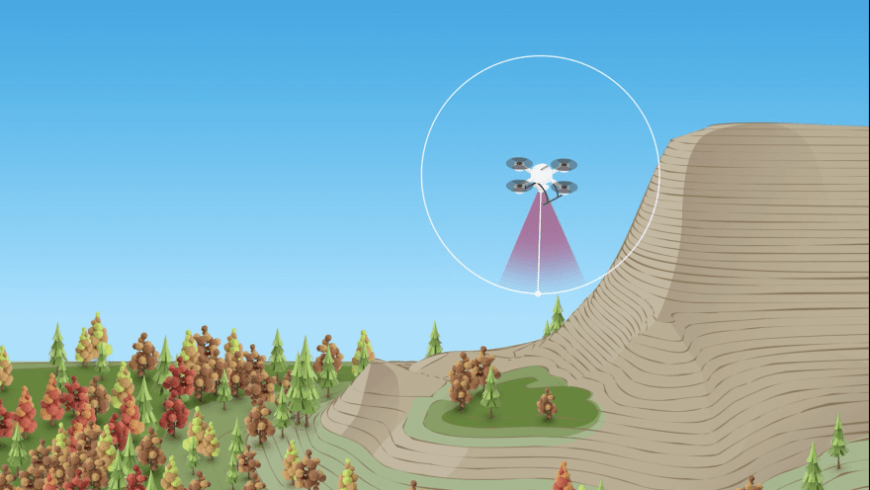
Keeping a mapping drone at a safe distance from rugged vertical terrain during its mission requires intense planning and a GNSS-enabled technology called “terrain following.” A new online video series and free webinar document the real-life challenges and hazards that professional surveyors encounter in their work, this among them.
 The “Down to Earth” series premieres on February 19. Register here to watch the free webinar at either 9 am Eastern time or 6 pm Eastern time.
The first three episodes of 5 to 6 minutes each, set in Arkansas’ rugged Ozark Mountains, will air during the webinar. After each episode the surveyors themselves discuss the actions and results: a vice president and the survey coordinator/UAV pilot from Crafton Tull engineering and surveying firm, with personnel from drone provider Microdrones.
“The Ozarks” mini-series depicts the obstacles encountered in mapping rugged mountains and a river canyon of steep bluffs, and the tactics used to overcome them. The surveyors’ mission: collect geospatial data on 150 acres of the cliff-filled region of Big Creek so that the firm’s engineers can design a road through the heart of the mountainous terrain.
“The challenge on this project is the terrain, from surveying the top to the bottom of the mountain,” said Crafton Tull Vice President of Energy Services, Nick Tucker.
“It’s dangerous [for a drone] because there are some sheer bluffs on here that would be really challenging to get data on,”” added UAV pilot Jeff Davis.
The first terrain challenge greeting the crew on arrival was its steep and undulating nature: the drone had to be kept a safe distance vertically and laterally from changing surfaces, yet close enough to gather data. An exploratory flight revealed that the surveyors’ initial plan needed revision, so they broke the mission down into 3 pre-programmed flights and one manually controlled flight. At all times the drone was governed to keep a 40 to 50-meter distance from all land surfaces for optimal laser swath from the onboard LiDAR. A 30-meter tree canopy over much of the terrain complicated the picture.
Using high-resolution topographic data generated from NASA’s Shuttle Radar Topography Mission (SRTM) to form an accurate terrain model onboard the Microdrones mdLiDAR1000 UAV, the team got underway. With the company’s mdCockpit desktop mission planning software, they pre-programmed three corridor mapping flights. The drone carried two GNSS receivers: one chip for navigation, and a Trimble AV14 antenna integrated with the Applanix APX15 GNSS-inertial for post-processing the LiDAR data.
Microdrones Southern U.S. Sales Manager Matt Rosenbalm was confident that his company’s mdLIDAR1000 could overcome the daunting challenges of the Ozarks. “I always like to see what kinds of projects they’re using our systems to do,” Rosenbalm said. “This one is obviously putting everything to the test, and it’s kind of neat to see how we tackle this.” Rosenbalm was so confident, he took a co-starring role in the film, providing support and technical assistance on scene.
In episodes 2 and 3 the team adapts to new challenges and problems, collects and analyzes powerful deliverables with the Microdrones integrated system, and finds out if their mission was a success.
“We frame Down to Earth within the genre of a reality series, because part of the show is watching surveyors work out in the field, set up their equipment, and deal with all the different elements and challenges they face,” said Microdrones Marketing Director Bret Burghdurf. “Plus, it’s more engaging and fun to watch.
“But at the end of the day, whatever happens in the field, they’re still responsible for getting their job done. This series demonstrates how Microdrones can make that process more efficient with powerful end deliverables from our systems. If you want to see real surveyors overcoming difficult field challenges and collecting really good data, then watch Down to Earth.”
Further adventurous episodes are promised. Register here to watch the free February 19 webinar including all three current episodes of “The Ozarks.”


