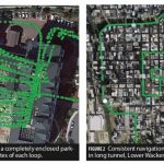
GNSS (all systems) Archives - Page 98 of 149 - Inside GNSS - Global Navigation Satellite Systems Engineering, Policy, and Design

GNSS (all systems)

December 20, 2016

New Report Says Broadcom and Qualcomm Top GNSS IC Vendors

GNSS IC Vendor Competitive Assessment Vendor Matrix. Image Source: ABI Research.

A new reports says that the GNSS market landscape is growing because of rapid growth of satellite technology-enabled wearables, unmanned aerial vehicles (UAVs), new innovation opportunities, and low-cost precision receivers.

ABI Research’s new GNSS integrated circuit (IC) vendor competitive analysis says that Broadcom and Qualcomm remain the two top companies for the fourth straight year.

Read More >

By Inside GNSS
December 9, 2016

Septentrio Rolls Out High-Precision Firmware for Its GNSS Receivers

Septentrio’s PolaRx5 GNSS receiver. Image source: Septentrio.

Septentrio has released its 5.1.0 firmware for the PolaRx5 product line of GNSS reference receivers. The PolaRx5 GNSS reference receivers include the PolaRx5 for Continuously Operating Reference Station (CORS) and network operations, time and frequency transfer, and space weather applications.

The 5.1.0 firmware includes new features for file management, usability, security, and seismic monitoring, the company said.

Read More >

By Inside GNSS
December 8, 2016

Two More Galileo Satellites Transmitting Navigation Signals

After months of testing, the European Space Agency (ESA) has announced that Galileo satellites 13 and 14 are transmitting healthy navigation signals and ready to relay distress calls to emergency services.

The satellites, launched from Europe’s Spaceport in French Guiana on May 24, went through lengthy testing that included receiving and uplinking signals through specialized antennas, ESA said. Some of the tests included navigation and search and rescue payloads methodically switched on, the agency said.

Read More >

By Inside GNSS
[uam_ad id="183541"]
November 30, 2016

GNSS Hotspots | November 2016

One of 12 magnetograms recorded at Greenwich Observatory during the Great Geomagnetic Storm of 1859
1996 soccer game in the Midwest, (Rick Dikeman image)
Nouméa ground station after the flood
A pencil and a coffee cup show the size of NASA’s teeny tiny PhoneSat
Bonus Hotspot: Naro Tartaruga AUV
Pacific lamprey spawning (photo by Jeremy Monroe, Fresh Waters Illustrated)
“Return of the Bucentaurn to the Molo on Ascension Day”, by (Giovanni Antonio Canal) Canaletto
The U.S. Naval Observatory Alternate Master Clock at 2nd Space Operations Squadron, Schriever AFB in Colorado. This photo was taken in January, 2006 during the addition of a leap second. The USNO master clocks control GPS timing. They are accurate to within one second every 20 million years (Satellites are so picky! Humans, on the other hand, just want to know if we’re too late for lunch) USAF photo by A1C Jason Ridder.
Detail of Compass/ BeiDou2 system diagram
Hotspot 6: Beluga A300 600ST

Highest altitude fix for a GPS signal, GNSS timing signals and hacking the Grid, Eagles act as drone countermeasures and rumors of a GNSS-nano-chip contributes to cash crisis in India

Read More >

By Inside GNSS

Exit, Pursued by a Bear

American Election 2016 — now that was something, wasn’t it?

A national unpopularity contest. Sort of Commedia dell’arte meets Monty Python, directed by Todd Phillips, with a cameo appearance by Berlusconi.

Did we find it risible? Oh, yes, but were those tears of laughter, sorrow, or disbelief?

So, while we are collectively unpacking the meaning and nonsense from two years of political theater and telling each other our fortunes for the next four, what does it portend for GNSS?

Well, the tea leaves are a little unclear.

Read More >

By Dee Ann Divis

How Will GNSS Fare Under a Trump Administration?

With the Republican Party now entirely in charge of Washington’s prime policy real estate the neighborhood is going to change. The current residents are warily watching the newcomers take measurements for a major remodel of agencies, lobbying rules, national priorities, and international relationships, and everyone is assessing the implications of the new landscape.

Read More >

By Dee Ann Divis
November 21, 2016

Hitachi Uses Trimble Grade Control System

Trimble GSC900 Allows Precision Excavation

Trimble has announced that the Hitachi Construction Machinery’s ZX200X-5B semi-automatic excavator is now available in Japan with the GCS900 Grade Control System.

The system uses GNSS, laser, sonic, or total station technology, to position the heavy machinery’s blade or bucket in real-time, for significant reduction in material overages and improving the contractor’s productivity, the company said. The unit makes design surfaces, grades, and alignments accessible to the operator inside a cab, Trimble said.

Read More >

By Inside GNSS
[uam_ad id="183541"]

FIG Working Week 2017

Paasitorni by the Sea, Helsinki

The International Federation of Surveyors (FIG) FIG Working Week 2017 will take place on May 29 – June 2, 2017, at the Messukeskus Expo and Convention Centre in Helsinki, Finland.

Registration will open in November, 2016. Abstract submissions are now closed.

Read More >

By Inside GNSS
November 16, 2016

NASA to Launch Satellite-Based GNSS Hurricane Watch

NASA plans to launch the Cyclone GNSS (CYGNSS) hurricane mission aboard a Pegasus XL rocket on December 12 from Cape Canaveral Air Force Station in Florida. CYGNSS, which is NASA’s first Earth science small-satellite constellation, will help improve hurricane intensity, tracking, and storm surge forecasts, the agency said.

Read More >

By Inside GNSS

NOAA Expands GNSS Data Sources for Weather Prediction

The National Oceanic and Atmospheric Administration (NOAA) will purchase data from small commercial satellites to expand its GNSS radio occultation (RO) efforts to better predict weather.

In September NOAA, through the government’s Commercial Weather Data Pilot program, awarded contracts to San Francisco, California-based Spire Global ($370,000) and GeoOptics ($695,000), of Pasadena, California, to provide RO data. This data will be used to assess whether commercially provided information can be incorporated into the agency’s weather models.

Read More >

By Inside GNSS
IGM_e-news_subscribe