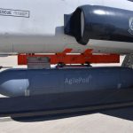
The Air Force Strategic Development Planning & Experimentation Office demonstrated fused PNT technologies within an AgilePod during six successful Phase I sorties on an airborne testbed in Centennial, Colorado in April.
The Defense Advanced Research Projects Agency (DARPA) has awarded Northrop Grumman a $13.3 million contract Phase 2 of the Blackjack program to “advance its Position, Navigation, and Timing (PNT) payload through emulation and Critical Design Review, and build PNT payload units destined for space flight.”
The first powered, controlled flight on another planet, now re-scheduled for no earlier than April 14, will employ inertial technology to navigate Ingenuity.
A new tome — make that two new tomes — join the bookshelf of essential and authoritative references for GNSS users, while widening the umbrella a good deal to cover all PNT technologies, their sensors and their integrations. Edited by four leading lights of the community and assistant-edited by two more, its list of authors rounds up another 131 of the “usual suspects,” the names that are seen repeatedly in the presentations at technical conference and on their organizing boards. In every one of 64 subject matters, the author(s) is/are recognized experts, in many cases the recognized expert, on the material.
Jackson Labs Technologies, Inc. announced availability of the STL-2600 Satellite Timing and Location (STL) receiver designed in partnership with Satelles, Inc., the service provider of STL. This commercial receiver provides a completely GNSS-independent, low-cost capability to generate UTC nanosecond timing and meters-accurate positioning anywhere in the world
Here, in no particular order save vaguely chronological, are the editor’s picks for Top Twelve GNSS and PNT Tech Stories of 2020: those that heralded technical breakthroughs significant for their time, that will continue to roll out wide-reaching developmental advances in 2021 and beyond.
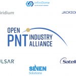
Ten companies active in positioning, navigation, and timing (PNT) have formed the Open PNT Industry Alliance. The coalition seeks to fortify economic and national security by supporting government efforts to accelerate the implementation of backup PNT capabilities for critical infrastructure.
HERE, a navigation platform with its map data services found in 150 million vehicles worldwide, and what3words, an addressing system which has divided the world into a grid of millions of 3-meter squares, have partnered to offer precision in-car navigation.
Ramjack Technology Solutions and Syntony GNSS have partnered to deliver underground GNSS positioning, navigation and timing (PNT) solutions, using Syntony’s SubWave technology.
The U.S. Department of Defense awarded a $1.7 million contract to Orolia Defense and Security for multiple BroadSim advanced GPS simulator systems for testing facilities and field test assets.
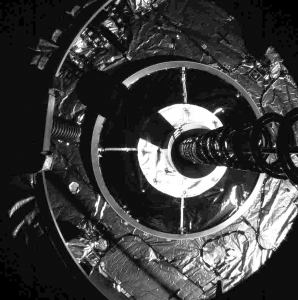
In late February, Northrop Grumman’s Mission Extension Vehicle MEV-1 autonomously docked with another satellite in geostationary orbit in space, making navigation history. It simultaneously took the next step in satellite operation by extending Intelsat 901’s lifetime beyond its original plan. The so-called “rescue satellite,” built by Northrop Grumman subsidiary Space Logistics, used a combination of traditional ranging, optical orbit determination from ground, and on-board sensors (visible, infrared, and LiDAR) for relative navigation in space to make its ultra-precise rendezvous 35,786 km above Earth.
The successful operation means a potential sea change in satellite operation: their lifetimes can be extended, and defunct satellites can be moved to safer orbit even after their fuel supplies are exhausted.
The complex series of maneuvers to bring the two satellites together began with an October 2019 launch of the MEV-1. Northrop Grumman controllers undertook a series of engine burns to raise MEV-1’s orbit from its highly elliptical geostationary transfer orbit up to a circular orbit 300 km above the geosynchronous belt. Shortly thereafter, Intelsat decommissioned its satellite 901, and it used the last of its propellant to move into the GEO graveyard orbit.
MEV-1 approached.
For 19 days, MEV-1 advanced upon and withdrew from Intelsat 901, calibrating its navigation sensors: optical cameras, infrared cameras and side-scanning LiDAR to orient and position itself relative to Intelsat 901.
Images courtesy Northrop Grumman.
For the final delicate and very precise maneuver, on February 25 MEV-1 autonomously flew to 20-meter distance, pausing before resuming travel to the critical 1-meter docking position. It autonomously extended a docking probe, engaging an engine nozzle aboard Intelsat 901. A nozzle, by the way, that was never designed for docking purposes.
MEV-1 then extended a group of internal grippers to anchor the two satellites together.
The satellite duo are now jointly performing stack on-orbit checkouts. Later this month, MEV-1 will relocating the two of them to a GEO spot over the central Atlantic, where Intelsat 901 will take over services for another Intelsat satellite, providing C-band service in the Americas, Europe, and Africa.
MEV-1 will then, like the Lone Ranger, bid farewell to Intelsat 901 and move on to a new mission.
Echo Ridge LLC of Sterling, Virginia has been working with the Air Force Research Laboratory Center for Rapid Innovation to develop a way to determine position from non-GPS satellite signals in different frequency bands.
Septentrio and Analog Devices now combine their technology specialties, multi-frequency multi-constellation GNSS receivers and high-quality inertial measurement units (IMUs), respectively, to deliver centimeter-accurate positioning with 3D orientation (heading, pitch and roll), for applications such as automotive advanced driver assistance systems (ADAS) and industrial automation.
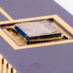
Draper has advanced its development of a LiDAR-on-a-chip using patented, all-digital MEMS optical switches for light beamsteering to gather the digital data to build high-definition maps.
To gauge the present state of mind of the GNSS and PNT community, the state of play in application development, and the state of the art in positioning, navigation and timing technology, we asked four international experts for their perspectives. Here are the questions posed to them.