March 24, 2020
A satellite firm now offering ship monitoring and tracking is studying whether it can use its new, formation-flying satellites to pinpoint GPS jammers and potential interference.
Virginia-based HawkEye 360 has had three microsatellites flying in sun-synchronous, polar orbit since early 2019. The Hawk satellites can detect radio frequency transmissions from the Earth’s surface and, by working as a coordinated cluster, independently determine the location of the source. They are currently being used to detect transmissions from the Automatic Identification System (AIS) devices ships are required to carry and independently geolocating the source so the reported and actual location of the ship can be compared and reported. The system can locate a transmitter with an accuracy of 500 meters depending on the signal. That could improve as HawkEye builds out its constellation.
The firm is already committed to putting another five clusters into space by the end of 2021 and HawkEye CEO John Serafini told Inside GNSS, there are plans to launch an additional cluster by mid 2022. Funding is in hand for the additional satellites thanks to a Series B round of financing completed earlier this year. With seven clusters of satellites in orbit the return rate — that is frequency with which a satellite will be flying overhead the same spot on Earth — will jump from about once every five hours to once roughly every 30 minutes, Serafini said.
Each satellite cluster flies in formation, a capability enabled by a specially designed propulsion system. Their software-defined radios are able to tune into frequencies ranging from 144 MHz to 15 GHz (approximately VHF to Ku-Band). To be detected from space the signal power on the ground has to be 1 watt or more.
“Generally speaking if the signal is above a watt in power — between 150MHz and 15 GHz — we can detect it and we can geolocate, process and analyze that signal,” Serafini said. Over the first 14 months of operation, Cluster 1 detected 11 million independent geolocations of various signals.
All this capability comes in pretty small packages. The initial three satellites weigh just 15 kg each. Starting with Cluster 2 that will jump to 25 to 28 kg each.
The firm’s originally targeted market leaned toward services for defense, intelligence and security applications. Now HawkEye is assessing offering a new service that would identify the location of GPS jammers.
“GPS jamming is on our product roadmap,” said Serafini and the company hopes to be able to offer the service in approximately six months. “We have to evaluate the opportunity and develop a product.”
It’s entirely plausible that HawkEye’s satellites could locate GPS jammers, according to Logan Scott of LS Consulting, an expert on both navigation and telecommunication signals. Scott said he’d been introduced to the technology a couple of years ago at a presentation and, though he’s not done a link analysis, believes it has potential for such a capability. “If it’s a big jammer. Yeah, I could definitely see something like that — there are some neat things you can do.”
It might also be possible to gain insight into spoofing, albeit indirectly. AIS data already has been used in this way by other organizations. If the AIS location data, for example, indicates that ships are traversing dry land, that strongly suggests spoofing.
Hawkeye might be able to do something similar based on other modes of transportation like trucks and trains. If there is publically available location data being transmitted by a truck or other asset, the satellites are capable of receiving those signals directly, said Serafini. Alternatively the firm could use data from a third party provider. If the reported location and the actual location don’t match that could be the result of spoofing.
“We have not done that yet,” said Serafini, “but we would, and we think there are databases that are commercially available that we could purchase depending on what the asset is that wants to be tracked.”
HawkEye could even map such disruptions over time. This might have been useful in the case of the truck driver whose GPS-jamming personal privacy device disrupted the ground-based augmentation system (GBAS) at the Newark Liberty International Airport in Newark, New Jersey when he drove past. The intermittent disruptions were a puzzle at the time.
The system may also be able to gather enough data to determine if signals in bands near those used by GPS could be interfering with GPS receivers. GPS users have most recently faced this possibility from a proposal by Ligado Networks, which wants to use satellite frequencies neighboring those used by GPS for a terrestrial service. With signal frequency, power and location data from the HawkEye system it could be possible to determine if Ligado signals were interfering with GPS equipment.
One of the challenges in doing that though, said Scott, would be identifying a particular transmitter that might be creating problems — especially if that transmitter is part of a network with other nearby transmitters. This is further complicated by the fact that communication transmitters aim most of their power at the ground.
“I don’t want to say impossible,” said Scott. “I don’t want to shortchange what these guys can do; they’re a very capable group. But at the same time, I’m trying to be cautious in my assessment.”
HawkEye is still engaged in its analysis it is too soon for additional detail about the potential for such a capability.
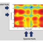
Scott suggested that HawkEye might be able to create a heat map that shows signals and their power at various geographic locations. “The heat map would be indicative of whether or not, in that area, you could expect to see problems.”
Serafini said they already have such a service.
“One of the products that we offer today is RFMosaic that looks at a specific geographic location and time and frequency range and maps the signals of interest that we see — the spectral energy in that area.”
RFMosaic includes features to help identify changes in RF activity over time and identify potential sources of interference, according to the company’s website.
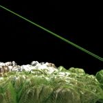
Art courtesy of Hawkeye 360
By Dee Ann Divis