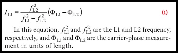
receiver Archives - Page 3 of 17 - Inside GNSS - Global Navigation Satellite Systems Engineering, Policy, and Design

receiver

July 21, 2014

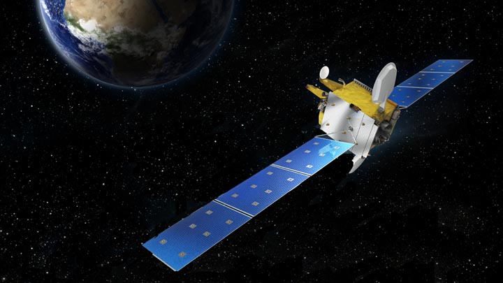
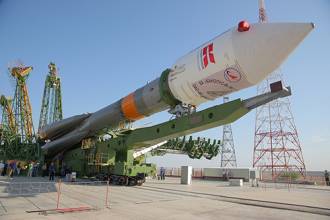
GPS Receiver Performance On Board a LEO Satellite

Equation 1

The small satellite “Technologie-Erprobungs-Träger 1” (TET-1) is the first spacecraft developed for the German Aerospace Center (DLR) On-Orbit-Verification (OOV) program, which provides flight opportunities dedicated to testing and qualification of new technologies in space. The satellite was lifted into a low-Earth orbit (LEO) on July 22, 2012, from the launch site in Baikonur, Kazakhstan.

Read More >

By Inside GNSS
January 19, 2014

Reaching for the STARx

Equation 1

GNSS modernization includes not only the global coverage capabilities of GPS, GLONASS, Galileo, and BeiDou, but also regional GNSS enhancement systems such as Japan’s Quasi-Zenith Satellite System (QZSS), the Indian Regional Navigation Satellite System (IRNSS), and the European Geostationary Navigation Overlay Service (EGNOS).

Read More >

By Inside GNSS
[uam_ad id="183541"]
May 2, 2013

MUSTER

Existing methods for improving the GNSS performance commonly attempt to enhance the signal processing and navigation estimation parts of a single receiver. Such approaches, however, leave unexplored the potential benefits inherent to the integration of data from multiple receivers.

Read More >

By Inside GNSS
March 13, 2013

Interstate GPS Receiver Passes M-Code Test

L-3 Interstate Electronics Corporation (L-3 IEC) announced today (March 12, 2013) that it successfully performed GPS Military Code (M-Code) testing during a “live sky broadcast event” last month.

The IEC M-Code receiver is designed to provide improved accuracy, positioning, navigation and timing in conditions where the performance of current receivers might be compromised or unavailable.

Read More >

By Inside GNSS
January 23, 2013

Markets and Multi-Frequency GNSS

FIGURE 1: Proposal to have a single chip GNSS receiver with additional pins to allow for the inclusion of an additional radio

Q: What will limit the spread of multi-frequency GNSS receivers into the mass market?

A: To set the scene, we need to define our terms of reference. By multi-frequency we mean receivers that operate with navigation signals in more than just the standard upper L-band from about 1560–1610 MHz where we find GPS L1, Galileo E1, Compass B1, and GLONASS L1. The obvious additional frequency is the lower L-band, from about 1170 to 1300 MHz, where again the same four constellations have signals.

Read More >

By Inside GNSS
[uam_ad id="183541"]
January 16, 2013

NovAtel Announces New BeiDou Capability for Its GNSS Products

NovAtel has announced support for the BeiDou Navigation Satellite System on its OEM6 family and selected OEMStar GNSS receivers.

The long-anticipated BeiDou Interface Control Document (ICD) release is a
significant milestone that facilitates global acceptance of the Chinese
GNSS system into the growing range of satellite-based positioning
applications, the company says.

Read More >

By Inside GNSS
December 18, 2012

Civil Galileo System Poses New Options for Secure Services

Conceptual design of ULTRA (ultra low-cost PRS receiver)

When European leaders first took up the idea of creating their own GNSS system nearly 20 years ago, they held up the concept of civilian control as a crucial differentiator from existing services operated by national military establishments.

As Galileo nears its operational phase, that principle may manifest itself in a surprising form: the opportunity to offer a range of security-oriented positioning and timing solutions in place of the all-or-nothing alternatives on encrypted services maintained by defense agencies.

Read More >

By Inside GNSS

GNSS IC Sales Approach $3 Billion Mark

ABI Research: GNSS IC market shares in non-cellular applications

Global sales of the smallest GNSS form factor — the integrated circuit (IC) — will exceed $3 billion next year, driven in large part by incorporation of position/location capabilities in smartphones, according to a leading research organization.

Read More >

By Inside GNSS
October 12, 2012

Trimble Introduces Next Generation GNSS Survey, Datalink, Mapping Solutions

Trimble R10 rover

Trimble has introduced its next-generation GNSS surveying solution — the Trimble R10, a small, lightweight receiver that introduces new features and technologies, including Trimble HD-GNSS, Trimble SurePoint, Trimble 360, and Trimble xFill, to provide increased productivity.

Announced at the Intergeo 2012 conference in Hannover, Germany, this week, introduction of the Trimble R10 was accompanied by new versions of its field and office software — Trimble Access 2012.20 and Trimble Business Center 2.80 to extend Trimble’s Connected Site survey solution.

Read More >

By Inside GNSS
IGM_e-news_subscribe