high precision positioning Archives - Page 4 of 9 - Inside GNSS - Global Navigation Satellite Systems Engineering, Policy, and Design

high precision positioning

NavCom Introduces Multi-GNSS SF-3040 Receiver
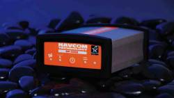
NavCom Technology’s SF-3040 Receiver

NavCom Technology, Inc., has launched its 66-channel, SF-3040 pole-mount receiver, featuring StarFire/real-time kinematic (RTK) multi-GNSS capabilities and optimized for surveying and mapping applications.

NavCom says its new product provides real-time kinematic (RTK)–level accuracy up to 40 kilometers away from the base station or decimeter-level accuracy anywhere in the world when using the company’s StarFire global satellite-based augmentation system (GSBAS).

Read More >

By Inside GNSS
April 7, 2011

Hexagon 2011 International Conference

A number of user conferences for customers of Hexagon AB’s precise measurement brands and products will be combined in the Swedish corporation’s first international conference this summer.

It will take place at Orlando World Center Marriott Resort in Orlando, Florida from June 6 through June 9, 2011.

The theme is "Building a Smarter World," and will include 200 technical and training sessions and an industry exhibition.

Read More >

By Inside GNSS
[uam_ad id="183541"]
March 18, 2011

NovAtel Announces FlexPak6 Enclosure Featuring OEM6 GNSS Technology

NovAtel FlexPak6

NovAtel Inc. has announced the launch of  its FlexPak6 GNSS enclosure, the first product to house the company’s new OEM628 multi-constellation receiver.

According to the Calgary, Alberta, Canada–based company, the 120-channel FlexPak6 is designed for easy integration into new user equipment and is capable of tracking all current and upcoming GNSS satellite signals, including GPS L1/L2/L2C/L5 (code and carrier phase), GLONASS L1/L2, Galileo E1/E5a/E5b/Alt-BOC, Compass/BeiDou-2 and satellite-based augmentation systems.

Read More >

By Inside GNSS
March 14, 2011

Japan Researchers Use GPS Permanent Array to Find Large Position Shifts From Devastating Earthquake

Based on data from Japan’s GPS Earth Observation Network System (GEONET), researchers at the Geospatial Information Authority of Japan (GSI) reported today (March 14, 2011)  that the 9.0 magnitude Tohoku earthquake on March 11 in northeast Japan caused an estimated displacement of between roughly 6 and 28 meters along two fault blocks totaling nearly 400 kilometers (248 miles).

Read More >

By Inside GNSS
March 11, 2011

ASCE -SPAR Geomatics Continuing Education Seminar

Marriott Convention Center

The American Society of Civil Engineers will offer a day-long program on Monday, March 21 at SPAR International 2011 that will focus on real-time GNSS positioning and using the 3D Global Spatial Data Model

Bill Henning, senior geodesist for the National Geodetic Survey, will lead  the morning session. With more than 43 years of experience in all phases of surveying technology, he is helping to develop guidelines and support methodology for real time GNSS position with state, national, and international organizations.

Read More >

By Inside GNSS
[uam_ad id="183541"]

GlobalGEO/ International Geomatic Week

Fira de Barcelona, Monjuic venue

The GlobalGEO Fair will take place in the Monjuic Venue, Hall 6 at Fira de Barcelona exhibition center in Barcelona, Spain from March 15 to March 17. 

The fair features the latest products for GPS navigation, 3D mapping, geographic information systems, photogrammetry, teledetection, geodesics, topography, satellite navigation, intelligent transport systems and communications.

Read More >

By Inside GNSS
November 30, 2010

United States Appeals Courts Disagree on GPS Technology and Privacy Rights

District of Columbia Court of Appeals in Washington D.C., USA

Secret tracking using GPS may be simple, undetectable and cheap — but appeals courts can’t decide if it’s constitutional.

In 1791, when the Fourth Amendment to the United States Constitution was ratified, it certainly seemed specific enough for the needs of the time. The new Americans were tired of colonial powers freely searching and seizing, with general warrants that were as full of holes as Swiss cheese.

Read More >

By Inside GNSS
November 1, 2010

UAV NAV Symposium (Royal Institute of Navigation)

Royal Geographical Society

A one-day symposium on navigation for unmanned aerial vehicles will take place at the Royal Geographical Society, 1 Kensington Gore, in London on February 1, 2011 from 9 a.m. until 7:30 p.m.

It is sponsored by the Royal Institute of Navigation (RIN) and will cover design and operation of UAVs, including:

• Mission planning
• Remote control
• Autonomous control
• Navigation sensors and integration
• Terrain mapping
• Legislation
• Safety

Read More >

By Inside GNSS
IGM_e-news_subscribe