high precision positioning Archives - Page 6 of 9 - Inside GNSS - Global Navigation Satellite Systems Engineering, Policy, and Design

high precision positioning

[uam_ad id="183541"]
September 8, 2009

American Geophysical Union (AGU) 2009 Fall Meeting

The American Geophysical Union (AGU) fall meeting includes more than 600 sessions and attracts 16,000 attendees from universities, government agencies and scientific societies. Its scientific program covers topics in all areas of Earth and space sciences and cuts across the boundaries of multiple disciplines.

It will be held in the West and South buildings at the Moscone Convention Center in San Francisco from December 14 to December 18 2009.

Read More >

By Inside GNSS
July 30, 2009

2009 FAA New Technologies Workshop

"Future Flight Technologies – the Wings of NextGen" is the theme of the Federal Aviation Administration’s 2009 New Technologies Workshop.

Registration and exhibit space are FREE.

The conference will focus on innovations for the transition to the Next Generation Air Transportation System as well as updates on existing programs, technology and new systems now in development.

Read More >

By Inside GNSS
[uam_ad id="183541"]
July 18, 2009

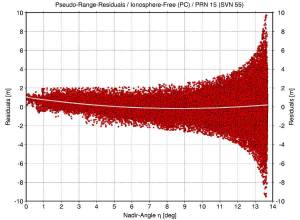
GPS Signal Anomalies: Is SVN49 Just the Tip of the Iceberg?

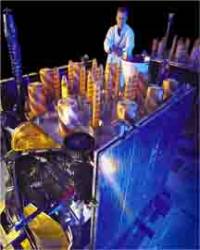
Block IIR Satellite L-Band Transmitter Array of 12 Helical Antennas. Lockheed Martin photo.

After GPS Wing engineers and contractors figure out how to solve the elevation-dependent signal anomalies on the latest GPS satellite — Space Vehicle Number 49 (SVN49), they may want to take a look at another nine Block IIR and IIR-M spacecraft that European scientists say exhibit similar, but less severe, behavior.

In an article that will appear in the July/August issue of Inside GNSS, Tim Springer and Florian Dilssner, GNSS engineers in the Navigation Support Office of the European Space Operations Center (ESOC), described the effects of the anomaly as well as the U.S. Air Force’s initial attempts to solve the problem by altering the broadcast satellite orbital positions and time. A version of the article was posted June 25 on the magazine’s website.

Read More >

By Inside GNSS
July 8, 2009

New RTCM Standard Supports Internet Streaming of GNSS Corrections to Mobile Users

The Radio Technical Commission for Maritime Services (RTCM) has completed a revision (Version 2.0) of its standard for Networked Transport of RTCM via Internet Protocol (Ntrip).

Designated as RTCM Standard 10410.1, Among other things, the new standard defined by RTCM’s Special Committee 104 (SC104) provides a protocol for streaming differential correction data or other kinds of Global Navigation Satellite System (GNSS) data to stationary or mobile users over the Internet.

Read More >

By Inside GNSS
April 26, 2009

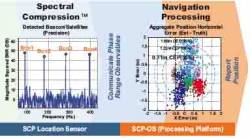
Loctronix Gains Patent for Its Spectral Compression Positioning, Tracks CDMA, GNSS

Loctronix SCP technology

[Updated 4/26/09] On March 31, the U.S. Patent Office granted Loctronix Corporation its first patent, which will provide the foundation for its Spectral Compression Positioning (SCP) technology that enables multi-source positioning capability in a single sensor. Subsequently, the company announced that it had successfully achieved meter-level ranging performance using CDMA cellular signals.

Read More >

By Inside GNSS
April 9, 2009

earthmine Launches 3D Mapping System Driven by GPS, Inertial

John Ristevski

Privacy rebellions such as recently drove a Google Street View crew from Broughton, England, or security-oriented legislation that would require blurred features or position accuracy in commercial imagery is just part of the market environment for 3-D mapping company earthmine, Inc., which is moving out of beta mode into full-fledged operations.

Read More >

By Inside GNSS
IGM_e-news_subscribe