
Based on data from Japan’s GPS Earth Observation Network System (GEONET), researchers at the Geospatial Information Authority of Japan (GSI) reported today (March 14, 2011) that the 9.0 magnitude Tohoku earthquake on March 11 in northeast Japan caused an estimated displacement of between roughly 6 and 28 meters along two fault blocks totaling nearly 400 kilometers (248 miles).
Based on data from Japan’s GPS Earth Observation Network System (GEONET), researchers at the Geospatial Information Authority of Japan (GSI) reported today (March 14, 2011) that the 9.0 magnitude Tohoku earthquake on March 11 in northeast Japan caused an estimated displacement of between roughly 6 and 28 meters along two fault blocks totaling nearly 400 kilometers (248 miles).
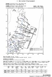
Preliminary results indicate that portions the Japanese mainland nearest the offshore epicenter of the quake moved up to several meters in a generally easterly and southerly direction. (See accompanying figure.)
With operation beginning in 1994, GEONET now consists of 1,200 GPS permanent stations with an average spacing of 20 kilometers (12.4 miles), comprising the largest GPS monitoring array in the world.
GSI researchers constructed a fault model using coseismic surface displacement data observed by GEONET, indicating that the displacement occurred in two rectangular faults with the following characteristics:
· A total major rupture length of ~400 kilometers with a fault width of ~80—90 kilometers. (northern segment: ~200 kilometers / southern segment: ~180 kilometers)
· A fault upper edge at a depth of 10 kilometers
· A reverse fault motion is inferred. Slip amounts of northern segment and southern one are estimated to be ~28 meters and ~6 meters, respectively
· A total moment magnitude is 8.8. (northern segment: Mw8.7 / southern segment: Mw8.2).
Results were reported by a research team including Imakiire Tetsuro, research coordinator for Geography and Crustal Dynamics Research; Tobita Mikio, head of Crustal Deformation Research Division; Ozawa Shinzaburo and Nishimura Takuya, chief researchers, Crustal Deformation Research Division; and Suito Hisashi, Researcher (Crustal Deformation Research Division) and Kobayashi Tomokazu, researchers, Crustal Deformation Research Division.


