Technical Article Archives - Page 2 of 12 - Inside GNSS - Global Navigation Satellite Systems Engineering, Policy, and Design

Technical Article

It’s Time for 3D Mapping–Aided GNSS
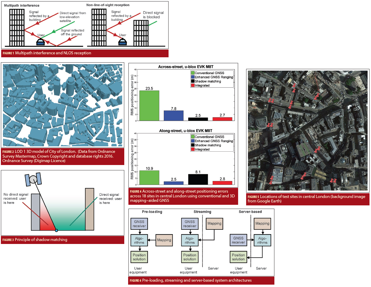
Figures 1-6

Real-time position accuracy, achievable in dense urban areas using low-cost equipment, is currently limited to tens of meters. If this could be improved to five meters or better, a host of potential applications would benefit. These include situation awareness of emergency, security and military personnel and vehicles; emergency caller location, mobile mapping, tracking vulnerable people and valuable assets, intelligent mobility, location-based services and charging, augmented reality; and enforcement of curfews, restraining orders and other court orders.

Read More >

By Inside GNSS
July 5, 2016

First Results

In February 2011, Russia launched the first satellite of the GLONASS-K1 series, i.e., SVN (space vehicle number) 801 (R26), which in addition to the legacy frequency division multiple access (FDMA) signals, for the first time was enabled to transmit code division multiple access (CDMA) signals on the GLONASS L3 frequency (1202.025 MHz). Later in 2014, the GLONASS program added SVNs 802 (R17) of series K1 and 755 (R21) of series M, and in 2016, SVN 751 of series M, with the capability of transmitting CDMA L3 signals to the constellation.

Read More >

By Inside GNSS

The International GNSS Monitoring and Assessment Service

Contemporary times have seen an increase in the number of navigation satellites across various geographical regions. In order to ensure that all these satellite systems work together to optimize the positioning, navigation, and timing (PNT) of users on or near the Earth’s surface there is need for inter-cooperation and inter-operability of the systems.

Read More >

By Inside GNSS
[uam_ad id="183541"]
May 19, 2016

Inter-Signal Correction Sensitivity Analysis

Symbols and Acronyms

Modernized GPS satellites give civil users the ability to achieve dual L1/L2 PY accuracy using dual L1CA/L2C ionosphere-free measurements and, with IIF satellites, dual L1/L5 signals. Because broadcast GPS ephemeris data is based on an ionosphere-free pseudorange calculated from dual L1PY/L2PY measurements and the civil signals are not all perfectly aligned to it, new broadcast parameters and a new modernized dual-frequency algorithm are needed in order to align new signals with the dual L1/L2 PY signal.

Read More >

By Inside GNSS

Listening for RF Noise

GNSS signals are vulnerable to interference due to being extremely weak when received on Earth’s surface. Therefore, even a low-power interference signal can easily disrupt the operation of commercial GNSS receivers within a range of several kilometers.

Read More >

By Inside GNSS
January 18, 2016

GAGAN — India’s SBAS

The GPS Aided Geo Augmented Navigation (GAGAN) system was developed by the Indian Space Research Organization (ISRO), together with Airports Authority of India (AAI), to deploy and certify an operational satellite-based augmentation system (SBAS). The system’s service area covers the Indian Flight Information Region (FIR), with the capability of expanding to neighboring FIRs. 

Read More >

By Inside GNSS

Measuring Navigation Payload Absolute Delay

Figures and Tables

In satellite navigation, the user receiver finds its position by measuring its distance to satellites and knowledge of the satellite position. The distance is measured by ranging, i.e., finding the delay of the signal from the transmitter to the receiver. The delay will comprise of payload hardware delay and the geometric range delay. Hence, the payload delay of the signal from generation to radiation is very important and needs to be transmitted in navigation data. 

Read More >

By Inside GNSS
[uam_ad id="183541"]
September 7, 2015

GPS Confidential

Ubiquitous location-aware mobile devices, mainly GPS-enabled smartphones, have led to a boom in location-based services (LBS), which have been revolutionizing businesses and lifestyles. Common uses of LBSs include asset tracking, location-based advertising, emergency roadside service, turn-by-turn navigation, and real-time traffic & road information sharing.

Read More >

By Inside GNSS

Urban Localization and 3D Mapping Using GNSS Shadows

It is by now well known that GNSS-based localization in built-up urban environments can be extremely inaccurate. This is a fundamental problem that hardware enhancements cannot solve.

A GNSS receiver estimates 3D location and timing from pseudoranges from four or more satellites, assuming that these pseudoranges correspond to direct line-of-sight (LOS) paths from each satellite. In urban canyons, however, the signal from a satellite to the receiver suffers from multipath propagation and shadowing.

Read More >

By Inside GNSS

GLONASS for Precise Navigation in Space

Figures and Tables

The current stage of GLONASS evolution is aimed at meeting future user requirements of which the most important is the improved accuracy of positioning.

During the implementation of the GLONASS Space Segment Modernization Program (2012–2015), the GLONASS team is facing the situation in which it is not feasible to launch new navigation satellites because the existing constellation is comprised of GLONASS-M satellites operating beyond their guaranteed design lifetime. Nine more GLONASS-M satellites are in ground storage.

Read More >

By Inside GNSS

Single Antenna, Dual Use

A GNSS single-antenna system can be compared to a single-pixel camera. Electromagnetic waves traveling 20,000 kilometers from every overhead direction can reach us. Yet once at the antenna, this diverse set of information is collapsed into a single magnitude and phase value, then sent off to the receiver so that value can be extracted.

Read More >

By Inside GNSS
June 29, 2015

Software-Defined GNSS Simulator: A Step Forward

A few studies (by universities and industry) have shown the feasibility of simulation of real-time digital intermediate frequency (IF) signals based on a graphics processor unit (GPU). And a couple of articles have also demonstrated use of a universal software radio peripheral (USRP)–based software-defined radio (SDR) as a simulator (in playback mode) in real test environments.

Read More >

By Inside GNSS

First Position Fix with IRNSS

Figure 1

The Indian Regional Navigation Satellite System (IRNSS) is an Indian Space Research Organisation (ISRO) initiative to build an independent satellite navigation system that provides precise position, velocity, and time (PVT) to users across the Indian region.

The primary objective of IRNSS is to achieve position accuracy of 20 meters (2σ) for dual-frequency users over India and the primary service area (a region extending to about 1,500 kilometers or 930 miles).

Read More >

By Inside GNSS
IGM_e-news_subscribe