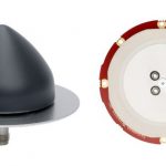
GNSS (all systems) Archives - Page 70 of 154 - Inside GNSS - Global Navigation Satellite Systems Engineering, Policy, and Design

GNSS (all systems)

October 22, 2019

Sifting for gold in the GSA’s new GNSS Market Report

The European GNSS Agency (GSA) has just issued its sixth annual GNSS Market Report, a booklet that comprehensively runs down the major market sectors and gives gratifying growth figures for all of them.  This is not news, strictly speaking.  This is more of the same that we have seen over the last two decades, the last six years of which have been quantified in the sturdy GSA Market Reports.

Read More >

By Inside GNSS
October 20, 2019

CYGNSS satellites use reflected GPS signals to predict hurricane paths

The Cyclone Global Navigation Satellite System (CYGNSS) constellation operated by the U.S. National Aeronautics and Space Administration (NASA) consists of eight miniature satellites that use GPS signals bounced off the sea surface to measure wind speeds. One after the other at 12-minute intervals, the satellites pass over tropical storms, gathering data that can be used to predict the storms’ path and their intensity.

Read More >

By Inside GNSS
October 17, 2019

EGNOS V3 capability aloft; takes effect in 2024

The newest EGNOS satellite is aloft. Eutelsat’s 5 West B satellite was successfully launched from Kazakhstan on October 9. Among other payloads, the 5 West B carries a GEO-3 payload of the European Geostationary Navigation Overlay System (EGNOS), Europe’s regional satellite-based augmentation system (SBAS). The satellite will support EGNOS V3, the next generation of the EGNOS program.

Read More >

By Inside GNSS
[uam_ad id="183541"]
October 16, 2019

Hot Jamming Topic Draws International Attention: Free Webinar

The latest offering of Inside GNSS’s continuing professional education series explores in depth what is likely the hottest topic at PNT technical gatherings over the last two years:  Detection and geolocation of GNSS interference sources. This September’s ION GNSS+ conference devoted 4 full technical sessions to interference, and across the program at least 28 technical papers and a tutorial focused on the issue. Clearly it is of the moment, as well as complex to understand and counter.

Read More >

By Inside GNSS
October 15, 2019

Collins’ MAPS II next-gen mounted nav system chosen for critical assured PNT

The U.S. Army selected Collins Aerospace Systems, a unit of United Technologies Corp. to provide a next-generation Mounted Assured Positioning, Navigation and Timing System (MAPS) for the Army’s increasingly sophisticated manned ground vehicles. Known as “MAPS Gen II,” the system will maintain the integrity of positioning and timing during operations in GPS-contested environments. 

Read More >

By Inside GNSS

Galileo to the rescue in Operation Shark Bait

A live demonstration in the North Sea used the Galileo Search and Rescue (SAR) service to initiate an emergency rescue in three and a half minutes after a “person in distress” operated her Galileo-enabled personal locator beacon (PLB) from a small life raft, adrift on the open water.

Read More >

By Inside GNSS
[uam_ad id="183541"]
October 13, 2019

UWB and microwave technology furnish indoor positioning

While many industries benefit from GNSS, others have not though their need cries out loud.  Manufacturing, indoor transportation and logistics, to name a few. Massachusetts-based Humatics furnishes indoor navigation systems for areas where GNSS technology does not perform well. Its core concept is “constellation” installations of high-frequency radio transmitters to enable centimeter- and millimeter-scale microlocation technology for positioning, navigating and collaborating.  

Read More >

By Inside GNSS

Satelles, Inc. Secures $26 Million in Series C Funding Round Led by C5 Capital

Satelles, Inc. (www.satellesinc.com), provider of highly secure satellite-based time and location services, announced that it has raised $26 million in Series C funding. C5 Capital (www.c5capital.com) led the round, with participation from Iridium Communications (www.iridium.com) and existing investors. This new investment brings Satelles’s total funding since the launch of its platform to $39 million and will help the company expand its sales and marketing efforts, broaden its partner network, and accelerate product development.

Read More >

By Inside GNSS
October 9, 2019

India’s NavIC SatNav Approved for Cell Phone, Tablet Use

The global wireless communications standards body 3GPP has accepted the interface specifications of NavIC, India’s regional satellite navigation system. With this permission, NaVIC can be integrated into devices like smartphones and tablets. The announcement givea a big boost to India’s mobile telecom industry while also encouraging use of NavIC throughout the Asia-Pacific region.

Read More >

By Inside GNSS
October 3, 2019

Enhanced GNSS Location over 5G Networks Trialed by ESA

Positioning with 5G next-generation cellular technology, based on higher bandwidths and frequencies, promises to open up new possibilities for localization services. As GNSS receivers share their position awareness across more powerful cellular networks, smart traffic management, asset tracking and personalized drone-based delivery will be just three examples of expanded capability. A European Space Agency (ESA)-sponsored test recently simulated this broadening PNT potential.

Read More >

By Inside GNSS
October 2, 2019

Vehicle Takes Three on Autonomous Drive from Midwest to D.C.

Autonomous vehicle research firm VSI Labs took its show on the road in September, as a three-member team was driven—by their autonomous car—on a thousand-mile journey from Minneapolis to Washington D.C. The Drive East employed Trimble’s precise point positioning (PPP) technology, Trimble RTX, delivering GNSS corrections via satellite or cellular.

Read More >

By Inside GNSS
1 68 69 70 71 72 154
IGM_e-news_subscribe