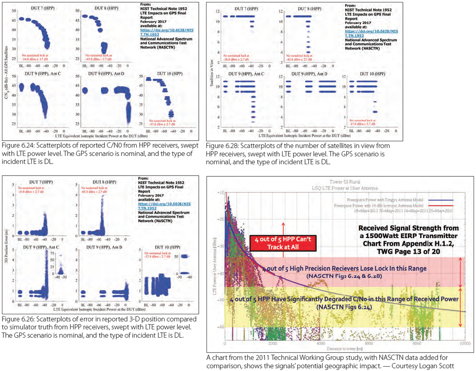
Survey and Mapping Archives - Page 9 of 27 - Inside GNSS - Global Navigation Satellite Systems Engineering, Policy, and Design

Survey and Mapping

October 7, 2016

Trimble Rolls Out SX10 Scanning Total Station

Trimble has released the SX10 scanning total station that merges high-speed 3D scanning, imaging technology, and total station measurements for surveyors, the company said.

"This is the top one or two [products] we have launched in the 20 years I’ve been here," said Ron Bisio, Trimble geospatial division vice president, at a media day in Westminster, Colorado, October 5.

Read More >

By Inside GNSS
September 22, 2016

Market Study See GNSS Growth in Autonomous Markets by 2021

A Google self-driving car in Mountain View, California. Wikimedia Commons photo by grendelkhan.

Low-cost, precision, GNSS receivers will become a reality in the driverless cars, drones, and smartphone markets by 2021, said ABI Research in two new reports, “Precision GNSS in Automotive” and “GNSS IC Design Trends: Modules, Standalone, Combo, and Embedded.”

The automotive industry will be the main driver behind precision GNSS receiver adoption, in which centimeter-level accuracy is essential to complete driver safety systems with the redundancy necessary for autonomous vehicles, the company said.

Read More >

By Inside GNSS
September 1, 2016

The Particular Importance of Galileo E6C

Equations

The Galileo E6 signal is centered at 1278.75 MHz, and comprises three signals: an authorized signal (E6A, the publicly regulated service, PRS plus two civilian signals), a data component (E6B), and a pilot component (E6C). Both E6B and C are modulated using binary-phase shift keying (BPSK) code division multiple access (CDMA) memory codes, having lengths of 5,115 chips and chipping rates of 5.115 Mcps.

Read More >

By Inside GNSS
[uam_ad id="183541"]
August 18, 2016

Hemisphere GNSS Launches OEM Boards

Eclipse P326

Hemisphere GNSS has introduced two new OEM boards, the Eclipse P326 and P327, designed for machine control, land or marine survey, and agriculture applications. The boards support GPS, GLONASS, BeiDou, Galileo, and Japan’s QZSS (Quasi-Zenith Satellite System).

The boards are the first within the Eclipse product line to have refreshed low-power capability, reduced size, cost, and weight, the company said. P326 and P327 offer centimeter-level accuracy in either single- or multi-frequencies, using signals from multiple GNSS constellations.  and Atlas-capable modes.

Read More >

By Inside GNSS
August 17, 2016

IWGRS2016: IEEE Workshop on Geoscience and Remote Sensing 2016

University Malaysia Putra – Engineering

IWUGR 2016 will take place at in Selangor, Malayia at the Universiti Putra Malaysia (UPM) in the Faculty of Engineering Auditorium on November 8 and 9.

IEEE Geoscience & Remote Sensing (GRSS) members will share knowledge and experience on recent developments and advancement in their fields, particularly on the topic of remote sensing for a sustainable environment.

The deadline for abstract submission is August 31.

Topics will include:
Geoscience and remote sensing technologies
Environmental and disaster monitoring

Read More >

By Inside GNSS
July 24, 2016

Ganiyu Ishola Agbaje

Ganiyu Ishola Agbaje is a geoinformation expert, with a Ph.D. in geography/geomatics from Lancaster University, an MPhil degree in GIS & remote sensing from the University of Cambridge, and MSc and BSc (Hons) degrees in surveying from the University of Lagos.

He is a registered surveyor and a Fellow of the Nigerian Institution of Surveyors.

Read More >

By Inside GNSS
July 17, 2016

Jade Morton: The Long and Scintillating Road

Jade Morton, in the front row at the right, with her sisters and grandmother

>>Jade Morton’s Compass Points

Yu — or Jade, in English — Morton is an electrical engineer, a professor at Colorado State University (bound for the University of Colorado Boulder in 2017), and a shining star in the world of GNSS. She left work for eight years to be a full-time mother, then returned to a university professorship and high-level research, where she has been recognized for her work on ionospheric effects on global navigation satellite systems.

Read More >

By Inside GNSS
[uam_ad id="183541"]
July 5, 2016

First Results

In February 2011, Russia launched the first satellite of the GLONASS-K1 series, i.e., SVN (space vehicle number) 801 (R26), which in addition to the legacy frequency division multiple access (FDMA) signals, for the first time was enabled to transmit code division multiple access (CDMA) signals on the GLONASS L3 frequency (1202.025 MHz). Later in 2014, the GLONASS program added SVNs 802 (R17) of series K1 and 755 (R21) of series M, and in 2016, SVN 751 of series M, with the capability of transmitting CDMA L3 signals to the constellation.

Read More >

By Inside GNSS

Federal Agencies Plan Shutdown of 37 Differential GPS Stations

Graphic Depicting NDGPS Coverage After Site Reductions

The U.S. Coast Guard, the U.S. Army Corps of Engineers (USACE), and the Department of Transportation (DoT) released a Federal Register notice today (July 5, 2016) announcing a reduction of the Nationwide Differential Global Positioning System (NDGPS).

The planned reduction calls for the shutdown and decommissioning of 37 DGPS sites, leaving 46 operational sites available to users in coastal areas. Termination of the NDGPS broadcasts is scheduled to occur on August 5, 2016.

Read More >

By Inside GNSS
June 15, 2016

Trimble Dimensions 2016

The 2016 Trimble Dimensions user conference and exhibition will take place at the Venetian Hotel in Las Vegas on November 7, 8 and 9.

The annual event gathers users of Trimble’s products including positioning technology for unmanned systems as well as mapping, GIS, surveying, photgrammetry and remote sensing and other technologies of interest to readers of Inside GNSS.

Four hundred and fifty technical sessions and networking events give attendees an opportunity to network widely within and among industry groups.

Read More >

By Inside GNSS
May 21, 2016

NovAtel Raises Concerns about Ligado Test Methodology, Results

NovAtel Inc. has submitted comments to the Federal Communications Commission (FCC) regarding Ligado Networks LLC’s (formerly New LightSquared LLC) License Modification Applications in which the company raises deep concerns about the testing methodology used and conclusions presented by Ligado regarding the impact of their proposed usage of L-band frequencies for a terrestrial wireless network.

Read More >

By Inside GNSS
May 19, 2016

Listening for RF Noise

GNSS signals are vulnerable to interference due to being extremely weak when received on Earth’s surface. Therefore, even a low-power interference signal can easily disrupt the operation of commercial GNSS receivers within a range of several kilometers.

Read More >

By Inside GNSS
1 7 8 9 10 11 27
IGM_e-news_subscribe