ODOT Deploys DT Research Purpose-built GNSS Rugged Tablets for Construction Projects
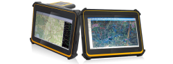
DT Research’s DT391GS Rugged GNSS TabletsSan Jose, California-based DT Research announced on January 9 the successful deployment of the DT391GS Rugged GNSS Tablets for the Oregon Department of Transportation (ODOT).
The DT391GS tablets with Intel Celeron Dual Core Processors are used as Inspector Positioning Tablets with the critical hardware and software needed for line and grade determination on stakeless highway construction projects.
The tablet comes with four GNSS module options including two from Hemisphere GNSS and two from Trimble. The GNSS options are:
By Inside GNSS