
March 21, 2023
Expanding the Role of GNSS in Seismic Monitoring
Identifying seismic signals in GNSS reference stations using machine learning.
By Inside GNSSGlobal Navigation Satellite Systems Engineering, Policy, and Design
Identifying seismic signals in GNSS reference stations using machine learning.
By Inside GNSS
In the wake of the latest COP session on international climate change, and as the world continues to deal with the effects of a warming planet, researchers say more and better data can help ameliorate the damage and provide answers on how to respond to it.
By Brett Davis
The European Union Agency for the Space Programme (EUSPA) has published its Earth Observation (EO) & GNSS Market Report, an outgrowth of its annual GNSS Market Report now that the agency has also taken on Earth observation among its administrative responsibilities. The Report is compiled and written for all those making these technologies part of their business plan and developing downstream applications.
By Inside GNSS
Trimble has rolled out the latest version of its core geospatial automated monitoring software, Trimble 4D Control version 6.3. The software provides automated movement detection to enable informed decisions about infrastructure for surveying, construction and monitoring professionals.
By Inside GNSS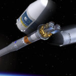
A Soyuz launcher operated by Arianespace and commissioned by ESA lifted off with the pair of 715 kg satellites from French Guiana on December 5. The two join 26 Galileo satellites in the orbiting constellation that now provide Initial Services.
By Inside GNSS
GeoOptics Inc. has upgraded its CICERO constellation of Earth-observation satellites to include advanced GNSS Reflectometry (GNSS-R).
By Inside GNSS
UrsaNav and ADVA have conducted an enhanced long-range navigation (eLoran) field trial using UrsaNav’s eLoran receiver and ADVA’s Oscilloquartz grandmaster clock technology. The successful demo showed that eLoran offers a robust and reliable backup for GPS and other GNSS and could be used to provide an assured position, navigation, and timing (PNT) service.
By Inside GNSS
Swift Navigation of San Francisco and Tokyo-based KDDI Corporation, a telecommunications company have partnered to bring precise positioning to the Japanese market.
By Inside GNSS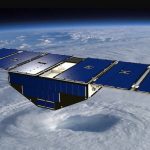
NASA has awarded a contract to the University of Michigan for the Cyclone Global Navigation Satellite System (CYGNSS) for mission operations and closeout. A constellation of eight microsatellites, the system can view storms more frequently and in a way traditional satellites are unable to, increasing scientists’ ability to understand and predict hurricanes. The total value of the contract is approximately $39 million. The CYGNSS Science Operations Center is located at the University of Michigan.
By Inside GNSS
In a demonstration of new services that NextGen TV can offer, BitPath, CAST.ERA and ONE Media publicly trialed “Enhanced GPS” broadcasts that could provide a tool for autonomous vehicle navigation and other applications.
By Inside GNSS
The Trimble GuidEx Machine Guidance System uses an integrated GNSS and inertial navigation system (INS) to compute a virtual reference point and precise heading, pitch and roll. This provides quick and efficient navigation along route corridors or to specific target areas,
By Inside GNSS
The European GNSS Agency (GSA) awarded a 1 million-euro research contract to RUAG Space for a study to increase the accuracy of space data provided by climate and environmental satellites.
By Inside GNSS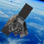
HydroGNSS, a small satellite built and operated by Surrey Satellite Technology Ltd, will measure Earth’s climate variables using GNSS reflectometry.
By Inside GNSS