The European GNSS Agency (GSA) awarded a 1 million-euro research contract to RUAG Space for a study to increase the accuracy of space data provided by climate and environmental satellites. By the end of 2022, RUAG Space will develop a new product dubbed NewSpace PPP Receiver (NEWSPAPER) that will be able to use the Precise Point Positioning (PPP) technique with Galileo’s new High Accuracy Service (HAS) transmitted on the Galileo E6 signal.
NEWSPAPER’s goal is to develop a GNSS receiving system geared towards the New Space market. “New Space” denotes a major to change from large, expensive satellites to constellations of smaller, cost-optimized satellites. This trend is seen in telecommunication applications, where hundreds or even thousands of satellites are planned to replace the large GEO satellites used in previous decades. The most well-known examples of such constellations are OneWeb, Telesat, Amazon’s Kuiper and SpaceX’s Starlink; several other telecom constellations are planned.
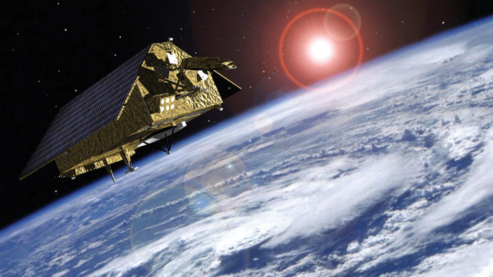
RUAG Space is developing a software update for navigation receivers of its current PODRIX receiver generation already in space, such as those used for the Sentinel-6 environmental satellite, which has been in space since November 2020. It measures the amount of sea level change and provides crucial data on coastal areas at risk from sea level rise. “The more accurate the satellite’s position can be determined, the more precise the environmental data it collects and provides. With the more accurate data, for example, the danger to coastal cities such as Venice can be predicted more effectively” declared Fiammetta Diani, Head of Market Development at GSA.
[Above photo: Navigation receivers from RUAG Space process Galileo signals, allowing the satellite’s position to be determined precisely. This in turn enables satellites such as Sentinel-6 (pictured) to collect precise environmental data. The precision of satellite navigation, and thus the accuracy of satellite data, is now to be significantly improved. Photo courtesy ESA, Airbus.]
To provide precise Earth observation data from space, a satellite’s position in space must be known as accurately as possible. To determine the exact position of satellites, RUAG Space’s navigation receivers today use the signals from the 22 European Galileo navigation satellites.
“Currently, there is still untapped potential in the Galileo satellites. They transmit several signals. On one of these signals a new service, the HAS, will support significantly improved positioning from 2022,” explains Martin Auer, who is leading the study at RUAG Space. “When this new service goes into operational use, it will need equipment that can do something with it. That’s what we’re working on.”
The software update will enable RUAG receivers in space to increase the accuracy of satellite positioning from the current level of about one meter to 20 centimeters. “This is a dramatic improvement – a quantum leap – in accurate satellite positioning that will contribute to much better climate and environmental data,” says Heinz Reichinger, the product manager responsible at RUAG Space.
A holding company headquartered in Zurich, Switzerland, the company has “divided itself in two,” with an aerospace supplier division headquartered in Vienna, Austria.
Applications
Satellite constellations whose data is driven by PPP navigation enable a number of applications in climate research, numerical weather prediction, safety of life services, satellite collision avoidance and in-orbit satellite servicing:
- Earth observation: will be done by constellations at much reduced re-visit time. PPP navigation therefore supports not only high spatial resolution but also much improved time resolution, which is increasingly judged by scientists to be at least as valuable as higher spatial resolution.
- Climate (change) monitoring: depends on the fusion of a lot of Earth observation sensor data that is distributed on ground, at sea, in the air and space. Even if these sensors provide sufficient accuracy and stability for long time climatological monitoring, data fusion is only possible if the time and position of the data takes are accurately determined. For that common reference frames are needed as supported by the proposed Galileo receiver.
- Improved Efficiency: By elevating navigation to previously unreachable accuracy, LEO orbit (position) resources can be used with much higher efficiency by many small satellites, for example in constellations. This leads to lower operation cost and significantly reduced collision risk.
- Economic Development: Telecom constellations providing communication on a global scale foster local business thanks to global connectivity. This provides work and income and generally drives economic growth in otherwise underdeveloped regions of the world.
- Saving of Lives: beforehand unavailable communication with emergency services will allow to reduce lead time of first responders. Even in densely settled areas with good telecommunications infrastructure, satellite communication systems with low latency as offered by LEO constellations will be beneficial to back terrestrial 5G networks. They allow for the interconnection of all the foreseen services.
- In-Orbit Servicing: High-performance GNSS receivers are used also on board of satellites designed for in- orbit servicing of other satellites.


