Septentrio, Artisense Demonstrating Advanced Localization Technology for Autonomous Vehicles
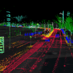
Septentrio, a manufacturer of high-accuracy GPS/GNSS technology for demanding applications, is providing positioning technology to Artisense, supplier of innovative computer vision solutions for automated vehicles. Artisense incorporates Septentrio GPS/GNSS in their latest Visual Inertial Navigation System (VINS), which was just demonstrated at the Auto.ai show in Berlin, Germany on September 25-27, 2019.
By Inside GNSS