GPS Archives - Page 26 of 28 - Inside GNSS - Global Navigation Satellite Systems Engineering, Policy, and Design

July 12, 2018

China Launches Another BeiDou Navigation Satellite

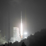
China sent a new BeiDou navigation satellite into orbit on a Long March-3A rocket from the Xichang Satellite Launch Center, in the southwestern Sichuan Province, at 4:58 a.m., Tuesday, July 10.

The satellite is the 32nd of the BeiDou navigation system, and one of the BeiDou-2 family, which is the second generation of the system. The state-run Xinhua press agency confirmed the launch within two hours after liftoff.

Read More >

By Inside GNSS
July 11, 2018

Harris Corp. Awarded $1.5B in IDIQ Contracts to Enhance NGA’s Global Geospatial Databases

Harris Corporation has been awarded three multi-award IDIQ contracts with ceilings totaling $1.5 billion to provide the National Geospatial-Intelligence Agency (NGA) with geospatial data services for up to 10 years.

Harris will create, manage and disseminate high-quality geospatial-intelligence (GEOINT) information for use by the U.S. intelligence community and military worldwide under contracts that cover all three areas of NGA’s JANUS program – geography, imagery and elevation.

Read More >

By Inside GNSS
July 10, 2018

Curtiss-Wright Highlights A-PNT Solutions for Ground Vehicles in GPS/GNSS-Denied Environments at JNC

Curtiss-Wright’s Defense Solutions division announced that it will highlight its family of commercial-off-the-shelf (COTS)-based modules and LRU solutions designed for system integrators seeking to rapidly and cost-effectively deploy Assured Position, Navigation and Timing (A-PNT) services at the 2018 Joint Navigation Conference, July 9-11 (Booth #109), the largest U.S. military Positioning, Navigation and Timing (PNT) conference of the year with joint service and government participation.

Read More >

By Inside GNSS
June 29, 2018

Inertial Sense Partners with DataTribe to Expand Autonomous Navigation

Inertial Sense announced last week that it has closed a $2 million round of seed funding led by DataTribe and supported by Atomic Ventures. Inertial Sense, a manufacturer of high-performance precision GPS-Inertial Navigation Systems, will use the funds to accelerate their market-leading position and advanced development of additional micro-navigation solutions and 3-D motion sensors.

Read More >

By Inside GNSS
June 25, 2018

GSA’s Cospas-Sarsat Meeting Addresses Progress of Search and Rescue Systems

The Cospas-Sarsat MEOSAR (Medium-Altitude Earth Orbit Search and Rescue) system has been in the news quite a bit of late, and with good reason. As the technology has evolved, so too has the ability to improve search and rescue operations which save lives.

The cover story for the current issue of Inside GNSS is dedicated to the Cospas-Sarsat MEOSAR system and its role as a solution to support the ICAO GADSS Autonomous Distress Tracking recommendation.

Read More >

By Inside GNSS
June 21, 2018

FAA Now Has Improved GPS Coverage Across U.S. as GEO 5 joins WAAS

The Federal Aviation Administration’s Geosynchronous Earth Orbiting 5 Wide Area Augmentation System (WAAS) navigation payload, developed by Raytheon’s Intelligence, Information and Services business, is now operational and fully integrated into the WAAS network. The GEO 5 payload joins two others already on orbit in correcting GPS satellite signal ionospheric disturbances, timing issues, and minor orbit adjustments, giving users increased coverage, improved accuracy, and better reliability.

Read More >

By Inside GNSS
June 18, 2018

Letter About Ligado in Limbo

The issue at hand is whether the Federal Communications Commission (FCC) should allow a change in the use of frequencies close to those used by GPS. Virginia-based Ligado Networks wants to repurpose its satellite frequencies to also support ground-based telecom services. Testing done several years ago and expanded upon more recently has shown such a system could seriously interfere with GPS receivers.

Some three months after a meeting of the key federal agencies using and running the GPS program, they have yet to release a letter stating their recommendation on whether to allow the development of a potentially interfering telecommunication service.

Read More >

By Dee Ann Divis
June 12, 2018

Innovate UK / KTN Hosting Technology Seminar: “Securing Positioning, Navigation & Timing”

Innovate UK / KTN (Knowledge Transfer Network) is hosting a technology focused seminar, “Securing Positioning, Navigation & Timing”, June 14 in London. It is designed to explore collaboratively, with users and providers, the need for back-up systems across all sectors and the contribution that may be made by two wide area systems (STL and eLoran) mentioned in the London Economics report.
This meeting is open to all with a professional interest in resilient PNT and is free to attend thanks to the generosity of the event’s sponsors.

Read More >

By Inside GNSS
IGM_e-news_subscribe