system interoperability Archives - Inside GNSS - Global Navigation Satellite Systems Engineering, Policy, and Design

system interoperability

January 11, 2017

Spirent Announces New GNSS/GPS Testing Software

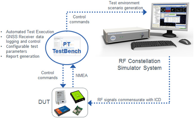
Spirent Communications’ PT TestBench.

Spirent Communications plc has announced the availability of PT TestBench — software designed to help technology, system and application developers build more accurate positioning functions more quickly. According to the company, the testing, analysis and reporting package automates testing of GPS and other global navigation satellite system (GNSS) receivers, so higher quality systems are brought to market faster and more reliably.

Read More >

By Inside GNSS
September 7, 2015

Let Us Now Praise

When China joined the GNSS club in 2007, it turned a satnav triumvirate into a quartet.

But some of the limelight needs to fall a little further from center stage — out there where the Indian Regional Navigation Satellite System (IRNSS) and Japan’s Quasi-Zenith Satellite System (QZSS) are not waiting idly in the wings.

Read More >

By Inside GNSS
February 10, 2015

GEOINT 2015: United States Geospatial Intelligence Foundation Symposium

Washington D.C. at sunset

The eleventh annual GEOINT Symposium and exhibition will take place on June 22 – 25, 2015 at the Walter E. Washington Convention Center in Washington D.C., U.S.A.

Registration for the GEOINT Symposium will open in February 2015.

The event will feature keynote speakers, breakout sessions, and provide attendees an opportunity to learn from leading experts, share best practices, and uncover the latest developments from government, military and private-sector leaders.


Read More >

By Inside GNSS
[uam_ad id="183541"]
January 22, 2014

GNSS Hotspots | January 2014

One of 12 magnetograms recorded at Greenwich Observatory during the Great Geomagnetic Storm of 1859
1996 soccer game in the Midwest, (Rick Dikeman image)
Nouméa ground station after the flood
A pencil and a coffee cup show the size of NASA’s teeny tiny PhoneSat
Bonus Hotspot: Naro Tartaruga AUV
Pacific lamprey spawning (photo by Jeremy Monroe, Fresh Waters Illustrated)
“Return of the Bucentaurn to the Molo on Ascension Day”, by (Giovanni Antonio Canal) Canaletto
The U.S. Naval Observatory Alternate Master Clock at 2nd Space Operations Squadron, Schriever AFB in Colorado. This photo was taken in January, 2006 during the addition of a leap second. The USNO master clocks control GPS timing. They are accurate to within one second every 20 million years (Satellites are so picky! Humans, on the other hand, just want to know if we’re too late for lunch) USAF photo by A1C Jason Ridder.
Detail of Compass/ BeiDou2 system diagram
Hotspot 6: Beluga A300 600ST

1. E-CROWDSHIPPING
Palo Alto, California USA

Read More >

By Inside GNSS
January 19, 2014

Proposal for U.S. eLoran Service Gains Ground

Trying to revive a years-dead federal program is usually the kind of hopeless task that even Sisyphus wouldn’t touch.

But determined supporters of eLoran are gaining ground in their effort to resurrect the cancelled radio-navigation network and, propelled by new worries over GPS jamming, they appear poised push the issue through.

Read More >

By Dee Ann Divis
[uam_ad id="183541"]
March 12, 2013

ESA Achieves First Galileo-Only 3D Position Fix

Measurements of individual Galileo horizontal position fixes performed for the first time using the four Galileo satellites in orbit plus the worldwide ground system between 1000 and 11:00 CET on Tuesday 12 March 2013, showing an overall horizontal accuracy over ESTEC in Noordwijk, the Netherlands, of 6.3 meters. ESA figure

The European Space Agency (ESA) has announced a key milestone today (March 12, 2013) in the development of Europe’s GNSS program: the first determination of a ground location using the four Galileo satellites currently in orbit together with the system’s ground infrastructure.

This fundamental step confirms the Galileo system works as planned, according to ESA scientists.

Read More >

By Inside GNSS
July 11, 2012

14th IAIN World Congress: International Association of Institutes of Navigation

Concorde El Salam Hotel

The biennial International Association of Insitutes of Navigation (IAIN) World Congress will take place in Cairo, Egypt from October 1 to October 3, 2012, in conjunction with MELAHA 2012, the 6th Arab Institute of Navigation conference and exhibition.

The conference venue is the Concorde El Salam hotel in the tranquil Helipolis suburb, a 10 minute drive from the airport

The theme is "Seamless Navigation: Challenges and Opportunities."

Read More >

By Inside GNSS
September 6, 2011

3rd Asia Oceania Regional Workshop on GNSS

Scenic Jeju Island

The third Asia Oceania Regional Workshop on GNSS will take place on Jeju Island, Korea on November 1 and 2, 2011.

Japan’s first Quasi-Zenith satellite "Michibiki" is now transmitting positioning signals and its technical and application verificationr results will be a major topic at this year’s event. 

Read More >

By Inside GNSS
1 2 3 4
IGM_e-news_subscribe