July 17, 2012
SIDEBAR: Requirements for Precision-Based Integrity and Geodetic Quality Control in UAV-Based SAR Missions
Return to main article: "Drones to the Rescue!"
By Inside GNSSGlobal Navigation Satellite Systems Engineering, Policy, and Design
Return to main article: "Drones to the Rescue!"
By Inside GNSS
Return to main article: "Drones to the Rescue!"
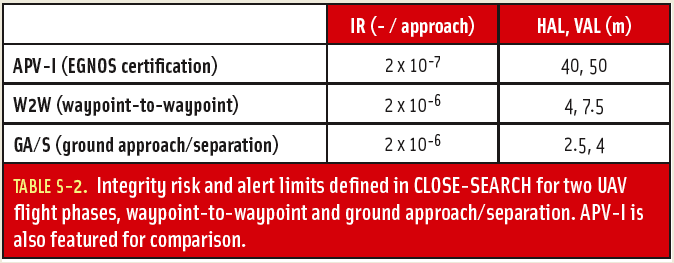
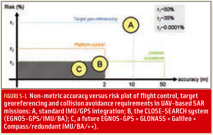
Following a route defined by application requirements and remotely sensing the environment in order to analyze and interpret the outcome on- and off-line: this is the axioma of every aerial remote-sensing mission and, indeed, also for search missions. Yet, the specific requirements for navigation might vary according to the application.
By Inside GNSS
August 1994, early morning. Spain’s Central Pyrenees Mountains still in darkness.
At the outset of an ascent to a 3,000-meter peak along the international border, one of the co-authors encounters a group of tourist hikers who have begun searching for a colleague who had left the camp the previous evening. In the pre-sunrise gloom, helicopters cannot yet operate.
A week later, the body of the hiker is found. The rescue efforts came, unfortunately, too late.
By Inside GNSS
Leica Geosystems Mining and Locata Corporation will continue their exclusive technology partnership in the mine machine automation and mine fleet management markets until at least June 2014. The extension guarantees the ongoing, commercial provision to the global mining industry of the Leica Jigsaw Positioning System (Jps), powered by Locata technology.
By Inside GNSS Business School, University of Nottingham Jubilee Campus
The Royal Institute of Navigation will hold a new navigator seminar and networking opportunity at the University of Nottingham on June 14, 2012 for new navigators, engineers, scientists and surveyors who are seeking careers in the industry.
Masters and doctoral level students will present on navigation and positioning topics, advanced undergraduates and postdocs will be in attendance. A number of industry and government representatives will exhibit or attend to listen to new research and meet the new talent.
By Inside GNSS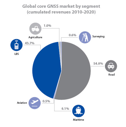
The European GNSS Agency (GSA) has published its second GNSS market report, including a special focus on maritime and surveying application markets and refining its projections of unit and sales revenue volumes through 2020.
According to the new GSA report, the worldwide GNSS market is growing rapidly with total market size expected to increase at an average of 13 percent per year until 2016. At that point, increasing market saturation, price erosion, and platform convergence will reduce the growth rate.
By Inside GNSS
NovAtel Inc. today (May 30, 2012) announced the development of their OEM625S Selective Availability/Anti-Spoofing Module (SAASM) GNSS receiver, the first product emerging from a collaborative effort with L-3 Interstate Electronics Corporation (IEC).
The OEM625S, which becomes available for purchase in the third quarter of this year, will combine a commercial dual-frequency NovAtel GNSS receiver with an L-3 IEC XFACTOR SAASM in a single card solution, reducing overall size and power requirements for end customer applications.
By Inside GNSS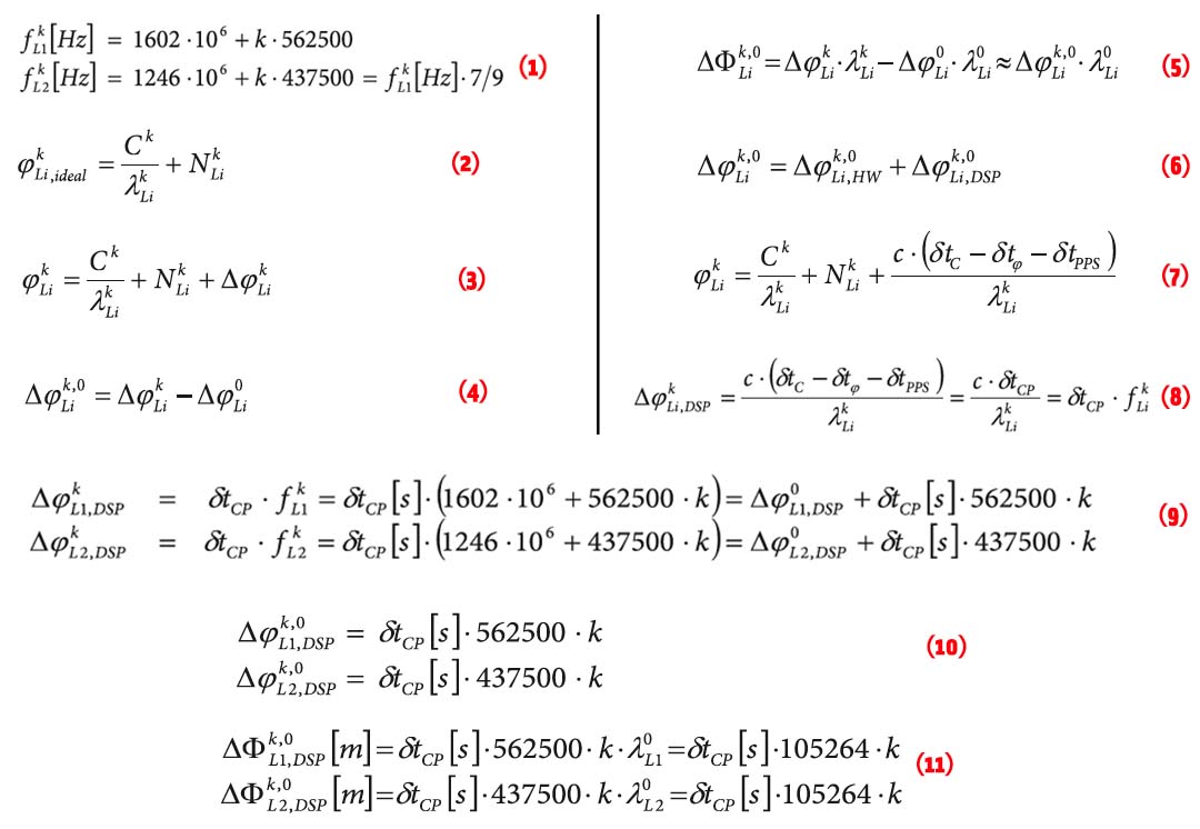 EQUATIONS 1 -11
GLONASS currently uses a frequency division multiple access (FDMA) technique to distinguish the signals coming from different satellites in the Russian GNSS constellation. The GLONASS L1 and L2 bands are divided into 14 sub-bands, and each satellite transmits in one of these.
The sub-bands are identified by frequency numbers k, from -7 to 6. The GLONASS L1 and L2 carrier frequencies, in hertz, at a frequency number k are defined by:

Working Papers explore the technical and scientific themes that underpin GNSS programs and applications. This regular column is coordinated by Prof. Dr.-Ing. Günter Hein, head of Europe’s Galileo Operations and Evolution.
By Inside GNSS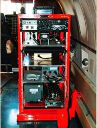 Typical Rack-Mounted UHARS System
A next-generation “truth” reference system for the U.S. Air Force (USAF) — the Ultra High Accuracy Reference System (UHARS) — is currently under development by the 746th Test Squadron (746 TS) at Holloman Air Force Base, New Mexico.
By Inside GNSS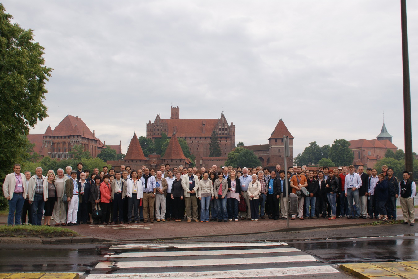 Transnav 2011
The 10th TRANSNAV symposium will be held June 19-21, 2013 at Gdynia, Poland, a seaport and resort city on the south coast of the Baltic.
The biennial event is an opportunity for scientists and professionals in navigation, transport, ocean engineering and maritime technology to share knowledge and research on all aspects of maritime navigation and safety of sea transportation. The symposium is held in English.
The organizers expect 300 participants from 50 countries or more.
By Inside GNSS Example of site logistic design by M.A. Mortenson Company using Google’s SketchUp 3D modeling tool
Trimble announced plans today (April 26, 2012) to acquire SketchUp, a popular 3D modeling tools, from its Silicon Valley neighbor, Google, Inc.
Sunnyvale, California–based Trimble signed a definitive agreement with Google, headquartered in Mountain View, with the transaction expected to close in the second quarter of 2012. Although the companies did not disclose financial terms of the deal, a Trimble news release said the transaction “is not expected to be material to 2012 earnings per share.”
By Inside GNSS Christopher Hegarty
Perhaps for the first time in the nearly 40 years of satellite navigation, all four GNSS programs and regional systems appear to have firm — if not always unencumbered — development paths ahead of them.
GPS, GLONASS, Galileo, Compass/Bei- Dou, Japan’s MSAS and QZSS, and India’s GAGAN and IRNSS systems are bringing new or modernizing elements into the world. Key program enablers — such things as budgets, satellite construction, launches and launch vehicles, new signal designs — all appear favorably aligned.
By Inside GNSS