March 3, 2026
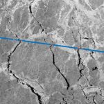
Spire GNSS-Reflectometry Data Enables Arctic-Wide Sea Ice Mapping
ESA-supported research reinforces the complementary role of commercial satellite data alongside government missions.
By Inside GNSSGlobal Navigation Satellite Systems Engineering, Policy, and Design
ESA-supported research reinforces the complementary role of commercial satellite data alongside government missions.
By Inside GNSS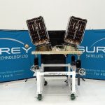
The European Space Agency (ESA) HydroGNSS mission is poised for launch at a moment of uncertainty in global climate diplomacy.
By Peter Gutierrez
Swift’s open, receiver-agnostic ecosystem removes integration barriers, reduces costs, and speeds time-to-market for industries requiring precise positioning.
By Inside GNSS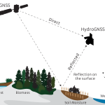
Partners in the European Space Agency (ESA)-funded HydroGNSS project, led by Surrey Satellite Technology Ltd (SSTL), will use GNSS reflectometry to provide measurements of key hydrological climate variables, including soil moisture, freeze–thaw state over permafrost, inundation and wetlands, and above-ground biomass.
By Peter Gutierrez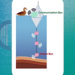
The ‘BIO.PNT’ project, funded by the European Space Agency (ESA), has developed a water quality monitoring system that combines biosensor and positioning, navigation and timing (PNT) technologies. The system enables the association of PNT data with detected organophosphate contamination in fresh water.
By Peter Gutierrez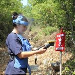
Trimble has announced its expanded support for The HALO Trust, the world’s largest humanitarian landmine-clearance non-profit organization. Trimble is donating an additional 175 Trimble Catalyst GNSS systems, including Trimble DA2 GNSS receivers.
By Inside GNSS
In the summer of 2024, France’s Center for the Study of the Biosphere from Space (CESBIO), working in collaboration with the French Space Agency (CNES) and Toulouse-based geolocation specialists M3 Systems, launched an airborne data collection campaign leveraging GNSS reflectometry to estimate forest biomass and soil moisture.
By Peter Gutierrez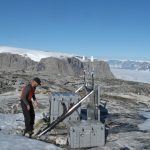
Researchers at the Technical University of Denmark (DTU) have developed a method to monitor daily ice loss in Greenland using data from 61 GPS stations installed on the bedrock around the island. This approach allows for precise tracking of ice melt, providing day-by-day data that enhances understanding of sudden changes in ice mass, especially during the summer.
By Inside GNSS
Researchers from Columbia University Climate School Lamont-Doherty Earth Observatory have published a 4-part field report from ongoing field work in the Tea Region of Bangladesh. The team is using GNSS to measure tectonics, earthquake hazard, as well as land subsistence in the face of climate change and sea-level rise.
By Inside GNSS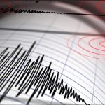
This study identifies the feasibility of leveraging deep learning anomaly detection to identify event-driven traveling ionospheric disturbances (TIDs).
By Inside GNSS
A recent research article in the journal Earthquake Science (EQS) reports on a novel use of GNSS data in seismology research performed in northeastern Tibet, the planet’s highest altitude area (elevations exceed 4500m).
By Inside GNSS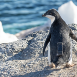
In an initiative aimed at conserving Antarctic wildlife, u-blox, known for its positioning and wireless communication technologies, has teamed up with Cellular Tracking Technologies (CTT), a specialist in wildlife telemetry and Internet of Things solutions.
By Inside GNSS