The fifth GPS III satellite rising in 2021 will ride aboard a previously used Falcon 9 first-stage booster, in a first for a National Security Space Launch mission. Space Exploration Technologies Corporation (SpaceX) has contracted with the U.S. Space Force’s Space and Missile Systems Center Launch Enterprise to reuse the booster rockets.
After a successful launch on the afternoon of June 30, the third Lockheed Martin-built GPS III satellite now heads to orbit under its own propulsion. The satellite has separated from its rocket and is using onboard power to climb to its operational orbit, approximately 12,550 miles above the Earth.
A group of Stanford Ph.D. and Masters graduates, with work experience among them at SpaceX, Ford Motor Systems, Blue Origin, Booz Allen Hamilton and other firms, has launched a start-up to start up a low-Earth orbit successor to GPS and other GNSS. The existing services, they say, are not up to the challenges of autonomy. They founded Xona Space Systems to supplant the venerable satnav systems.
The U.S. Air Force updated the GPS Standard Positioning System (SPS) Performance Standard (PS) in mid-April, 2020, the first new Performance Standard document since 2008. It includes mention of and pre-Initial Operating Capability (IOC) performance standards for the new civil GPS signals L2C and L5 for the first time. In another new feature, the document mentions “expanded capabilities which allow the total size of operational constellation to grow beyond the previous maximum of 32 Navstar satellites” for “more robust constellation availability to enhance the overall SPS SIS performance.”
A connected ambulance demonstrator develops a multitude of communications options on board, in preparation for a full healthcare connectivity development and test center in the UK.
Just like the kids valiantly doing their homework during this strange, removed time, PNT enthusiasts young and old around the world can put their isolation to good use by honing skills at home. “GPS: An Introduction to Satellite Navigation,” the massive online open course created by Frank van Diggelen and the late Per Enge, is available on YouTube.
Qinertia, a PPK software from SBG Systems, now supports third-party Inertial Measurement Units (IMUs) and offers a GNSS post-processing license that covers all major GNSS receivers.
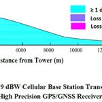
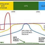
Though the FCC approved Ligado Networks’ request to use satellite frequencies to support terrestrial 5G, opposition to the move remains firm as everyone waits to see what kind of measures are included in the final decision to protect GPS from interference.
The five members of the Federal Communications Commission voted unanimously to approve a request by Ligado Networks to use satellite frequencies neighboring those used by GPS to broadcast from ground antennas for 5G, the agency announced Monday morning.
Federal Communications Chairman Ajit Pai’s step this week toward approving Ligado Networks’ request to use its satellite frequencies for a terrestrial 5G service comes after nearly a decade of testing that showed both versions of their proposal would interfere with GPS users.
The U.S. Air Force 2nd Space Operations Squadron has put the last operational GPS IIA satellite, SVN 34, into disposal cycle for April 13 to 20. This is effectively end of life, or space hospice if you will, for a satellite that has outlived its 7.5 year design span by 19 years.
The rite of passage brings to a close a 26.5-year era in which the IIA generation carried the gold standard of positioning 20,200 km (12,550 miles) above the Earth, circling the globe twice a day.
Nineteen Block IIA satellites, slightly improved versions of the Block II series (the first full scale operational GPS satellites), were launched from November 26, 1990 until November 6, 1997. The satellites were built by Boeing, formerly Rockwell Corporation. They broadcast the L1 C/A signal for civil users and the L1/L2 P(Y) signals for military users.
SVN-34, the last of its generation, was removed from service October 9, 2019 but kept on as part of the constellation as a decommissioned, on-orbit spare until April 13.
Second Lt. Kelley McCaa, 2nd Space Operations Squadron satellite vehicle operator, and Airman 1st Class John Garcia, 2nd SOPS satellite systems operator, set satellite vehicle number-74, the first iteration of GPS Block III vehicles, as healthy and active to users Jan. 13, 2020, at Schriever Air Force Base, Colorado. The GPS Block III vehicles replaced the GPS Block IIA satellites, marking the end of a 26.5 year era. (U.S. Air Force photo by Staff Sgt. Matthew Coleman-Foster)
In the disposal process, “We push the satellite vehicle to a higher, less congested, ‘disposal orbit’ to eliminate the probability of collision with other active satellites,” said Capt. Angela Tomasek, 2SOPS GPS mission engineering and analysis flight commander. “[Then,] the vehicle is put into a safe configuration by depleting the leftover fuel and battery life and shutting off the satellite vehicle transmitters so no one else can access the satellite in the future.”
“As we continue to manage the influx of GPS III and maintaining other vehicles in a residual status, we have to be cognizant of effective risk management,” Tomasek continued. “As SVN-34 continued to age, we had to manage its aging components and likelihood of having a critical malfunction. We are at a stage where we are confident in the robustness of the overall GPS constellation to remove the last remaining IIA vehicle.”
Once SVN-34 arrives in its final orbit, 2 SOPS will hand over full tracking responsibility to the 18th Space Control Squadron at Vandenberg AFB, California, where it will be treated and catalogued like every other space object, on April 20.
“This disposal marks the end of an era in GPS history,” said Lt. Col. Stephen Toth, 2nd SOPS commander. “There are senior leaders and long-time contractors [who] launched and operated the IIA satellites at the beginning of their careers [who] are now here to see it end. It is an opportunity to reflect on the legacy and heritage of 2 SOPS and GPS to see how far we have come.”
Thirteen agencies responsible for much if not most of the nation’s military, civil, security and economic activity say Ligado Networks’ plan to use satellite frequencies for 5G communications would interfere with GPS users in general and DOD use in particular.
Experts at the NATO Communications and Information (NCI) Agency have developed a software-based tool that can estimate the area where an interfering signal would degrade or deny GNSS signals, and assess the scale of the interfering signal and its potential impact on operations. Principally of interest are jamming or spoofing attacks on GPS or Galileo, of course.
The Radar Electromagnetic and Communication Coverage Tool (REACT), was sponsored by the NATO Navigation and Identification Programme of Work. It serves as a proof-of-concept of how analytical tools could support the execution of operations. The tool is also available to NATO Nations free of charge. For now, the software is only used for trial and experimentation.
NATO REACT, photo courtesy NCI
To use the software, operators input information on the particular jammers – their locations and technical characteristics — and the software produces a map of the area where the interfering signals would degrade or deny GNSS receivers. This can be displayed on the NATO Core Geographical Information System (GIS) map.
The next phase of the project focuses on ensuring the software can work on NATO classified networks, which would make it more available to operational commands to test and ensure such support measures are properly integrated into NATO operations.
The software and its estimations were demonstrated to operators during exercise Trident Jupiter 2019, part 1, to collect their feedback. The exercise gathered 3,000 military and civilian personnel as participants, evaluators and observers. Thirty NATO member and partner nations participated in nine different exercise locations across Europe.
“Ten consecutive twelve-hour working days and a relentless, ever-increasing, battle-rhythm tempo came to an end as Exercise Trident Jupiter 2019-1 (TRJU19-1) reached completion on Thursday, Nov. 14, 2019,” the agency stated.
TRJU19 was the largest and most complex exercise planned and executed by the Alliance’s Joint Warfare Centre to date. TRJU19-2 took place in March 2020.
“NATO’s adversaries have the ability to degrade or deny GPS-enabled capabilities,” said Jean-Philippe Saulay, a NATO Navigation and Identification Officer. “NATO must take appropriate measures to ensure Allied forces can operate in a degraded or denied environment.”
“NATO must maintain superiority in the electromagnetic environment, including but not limited to, positioning, navigation and timing services,” said Dr Enrico Casini, Communications and Navigation Engineer at the NCI Agency. “Situational awareness of navigation systems in a contested electromagnetic environment contributes to that superiority. NATO is enhancing its knowledge of electronic warfare technology,” Dr Casini said. “The electromagnetic environment has become even more contested in recent years. One aspect of that is interference with GNSS systems.”
Photos courtesy NATO Communications and Information Agency.
GPS keeps a digital twin sequestered in El Segundo, California. Galileo has an Earth-bound space vehicle in Noordwijk, the Netherlands, straining at its bonds, yearning to break free and fly with its brethren. Both constellation “ghosts” exist in an eerie testing twilight, being made to replicate the movements and reactions of their free-flying families. Their sacrifices could lead to better, more robust satellites in future generations.