satellites/space segment Archives - Page 3 of 23 - Inside GNSS - Global Navigation Satellite Systems Engineering, Policy, and Design

satellites/space segment

January 22, 2014

GNSS Hotspots | January 2014

One of 12 magnetograms recorded at Greenwich Observatory during the Great Geomagnetic Storm of 1859
1996 soccer game in the Midwest, (Rick Dikeman image)
Nouméa ground station after the flood
A pencil and a coffee cup show the size of NASA’s teeny tiny PhoneSat
Bonus Hotspot: Naro Tartaruga AUV
Pacific lamprey spawning (photo by Jeremy Monroe, Fresh Waters Illustrated)
“Return of the Bucentaurn to the Molo on Ascension Day”, by (Giovanni Antonio Canal) Canaletto
The U.S. Naval Observatory Alternate Master Clock at 2nd Space Operations Squadron, Schriever AFB in Colorado. This photo was taken in January, 2006 during the addition of a leap second. The USNO master clocks control GPS timing. They are accurate to within one second every 20 million years (Satellites are so picky! Humans, on the other hand, just want to know if we’re too late for lunch) USAF photo by A1C Jason Ridder.
Detail of Compass/ BeiDou2 system diagram
Hotspot 6: Beluga A300 600ST

1. E-CROWDSHIPPING
Palo Alto, California USA

Read More >

By Inside GNSS
June 4, 2013

Air Force Proposes Dramatic Redesign for GPS Constellation

[Updated June 3, 2013] With the budget vise tightening, top Pentagon managers are readying some potentially dramatic changes to the GPS constellation — changes that promise to lower both the cost of the satellites and the expense of putting them into orbit.  

The first changes would be subtle and are linked to buying the next block of GPS III satellites — a decision that sources confirm will be made by the end of September.  

Read More >

By Dee Ann Divis
[uam_ad id="183541"]
March 14, 2013

NavSAS, Septentrio Report Galileo IOV Positioning Results

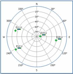
Skyplot of Galileo IOV satellite locations used in Septentrio position determination.

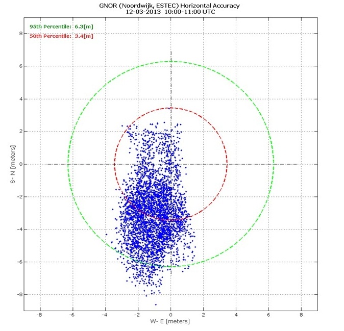
Two European organizations announced successful positioning results yesterday (March 12, 2013) using signals from the four Galileo in-orbit validation (IOV) satellites.

The NavSAS group of Politecnico di Torino and Instituto Superiore Mario Boella in Turin, Italy, obtained its first Galileo autonomous position using signals from the Protoflight Model (PFM) and three Flight Model space vehicles (FM2, FM3, FM4), which have started transmitting valid navigation messages.

Read More >

By Inside GNSS
March 12, 2013

ESA Achieves First Galileo-Only 3D Position Fix

Measurements of individual Galileo horizontal position fixes performed for the first time using the four Galileo satellites in orbit plus the worldwide ground system between 1000 and 11:00 CET on Tuesday 12 March 2013, showing an overall horizontal accuracy over ESTEC in Noordwijk, the Netherlands, of 6.3 meters. ESA figure

The European Space Agency (ESA) has announced a key milestone today (March 12, 2013) in the development of Europe’s GNSS program: the first determination of a ground location using the four Galileo satellites currently in orbit together with the system’s ground infrastructure.

This fundamental step confirms the Galileo system works as planned, according to ESA scientists.

Read More >

By Inside GNSS
[uam_ad id="183541"]
February 28, 2013

Lockheed Powers Up First GPS III Satellite Module

The core structure of the GPS III Non-Flight Satellite Testbed (GNST) stands in Lockheed Martin’s GPS III Processing Facility. Lockheed Martin photo

Well, the lights work. So far, so good.

The Lockheed Martin team developing the U.S. Air Force’s next-generation GPS III satellites has turned on power to the system module of the program’s first spacecraft, designated GPS III Space Vehicle One (SV-1).

According to the prime contractor, the achievement is a key indication that the team is on track to deliver the first satellite for launch availability next year, although the actual first launch will probably take place in 2015.

Read More >

By Inside GNSS
February 19, 2013

Air Force Awards Boeing Contract to Continue GPS Modernization

Boeing engineers with GPS Block IIF on production line. Boeing photo

The U.S. Air Force has awarded The Boeing Company a $51 million to continue modernizing the GPS satellite constellation for up to five more years. The contract covers GPS IIF satellite shipment to the launch site in Florida, pre-launch preparation, post-launch checkout, handover, and on-orbit support. It has an initial one-year term with four one-year options.

Read More >

By Inside GNSS
January 22, 2013

AFRL Selects Surrey Satellite US to Evaluate Small Satellite Approach to GPS

The Air Force Research Laboratory (AFRL) has selected Surrey Satellite Technology US LLC (SST-US), of Englewood, Colorado, to investigate cost reduction and augmentation of the current GPS constellation through the application of a small satellite approach.

AFRL has contracted with SST-US to identify and analyze how small satellites can improve aspects of GPS system performance, such as accuracy, coverage, and robustness at costs far below those of past procurements.

Read More >

By Inside GNSS
November 30, 2012

Retired GIOVE-A Satellite Helps Demonstrate High-Altitude GPS Navigation Fix

GIOVE-A mated with Fregat launcher upper stage. ESA photo

An experimental GPS receiver, built by Surrey Satellite Technology Limited (SSTL), has successfully achieved a GPS position fix at a 23,300-kilometer altitude — the first position fix above the GPS constellation on a civilian satellite, according to the company.

SSTL’s SGR-GEO receiver is collecting data that could help the company to develop a receiver to navigate spacecraft in geostationary Earth orbit (GEO) or even in deep space.

Read More >

By Inside GNSS
IGM_e-news_subscribe