Main Categories

10 High School Teams to Test Robots at the Smithsonian in the 2011 Mini Urban Challenge

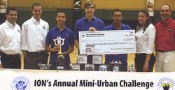
Pace High School “Catastrophic” team, the 2010 winner

Ten Lego kits transformed into autonomous robotic vehicles will gather, with their high school student masters, on Saturday, May 21 at the Smithsonian for the 2011 national championship of the Institute of Navigation Mini-Urban Challenge.

It all happens from 8 a.m. to 5 p.m. in the Spark!Lab and first floor of the Lemelson Center for the Study of Invention and Innovation on the National Mall.

Read More >

By Inside GNSS
April 23, 2011

GPS-Guided Honeywell MAV Aids in Japan Nuclear Plant Emergency

T-Hawk MAV. Honeywell photo

A GPS-guided T-Hawk Micro Air Vehicle (MAV) more frequently used in combat reconnaissance missions in Iraq and Afghanistan is being used to help emergency efforts at Japan’s damaged fukushima Daiichi nuclear plant.

Weighing just 17 pounds and measuring 14 inches in diameter, the T-Hawk is a ducted-fan vertical takeoff and landing air vehicle originally developed in recent years by Honeywell Corporation under a $40-million Defense Advanced Research Projects Agency (DARPA) technology demonstration contract.

Read More >

By Inside GNSS
April 19, 2011

Trimble Announces Plans to Buy Ashtech

Continuing a series of acquisitions in recent years, Trimble announced today (April 19, 2011) that the Sunnyvale, California–based company has entered into a definitive agreement to acquire privately held Ashtech S.A.S.

In announcing the its plans, Trimble said that it expects the acquisition of the Carquefou, France, company and its affiliates will expand the U.S. company’s Spectra Precision portfolio of survey solutions and allow the company to better address emerging markets worldwide.  

Read More >

By Inside GNSS
[uam_ad id="183541"]
April 18, 2011

Keeping the Spoofs Out

The demand for techniques capable of authenticating the GNSS signals and detecting simulation attacks (spoofing) has increased exponentially in the last years, mainly targeted to financial and safety critical applications.

Associated proposals and developments addressing these issues focused on two different approaches: user segment authentication services that leveraged existing services in order to detect signal spoofing and that integrated signal authentication services into the GNSS system itself.

Read More >

By Inside GNSS

Modernization Times

Enterprise Baseline Schedule

Col. Bernie Gruber, commander of the GPS Directorate since June 2010, works in a busy place.

Through its various incarnations since being established in 1974 — as Joint Program Office, Air Force Wing, and now Directorate — the GPS program at the Space and Missile Systems Center (SMC), Los Angeles Air Force Base, California, has been at the center of the action.

Read More >

By Inside GNSS
[uam_ad id="183541"]

Geneq Announced Dual-Frequency RTK GPS, OmniSTAR HP Receivers

Geneq SXBlue IIIL

Geneq Inc., a Montreal, Quebec, Canada, manufacturer, has introduced two new GPS products.

The SXBlue III-L is a compact GPS L1/L2 receiver in the world designed for use with OmniSTAR’s HP service to attain decimeter accuracy worldwide. Targeted at GIS mapping/surveying applications, the receiver measures 14 x 8 x 5.6 centimeters (5.57 x 3.15 x 2.22 inches) and weighs 517 grams (1.14 pounds) including battery.

Read More >

By Inside GNSS

NavCom Introduces Multi-GNSS SF-3040 Receiver

NavCom Technology’s SF-3040 Receiver

NavCom Technology, Inc., has launched its 66-channel, SF-3040 pole-mount receiver, featuring StarFire/real-time kinematic (RTK) multi-GNSS capabilities and optimized for surveying and mapping applications.

NavCom says its new product provides real-time kinematic (RTK)–level accuracy up to 40 kilometers away from the base station or decimeter-level accuracy anywhere in the world when using the company’s StarFire global satellite-based augmentation system (GSBAS).

Read More >

By Inside GNSS
April 9, 2011

Hey, Kids! Get Your Names on Europe’s Galileo Satellites!

If you are lucky enough to be nine to eleven years old and living in Belgium or Bulgaria, you could get your name on one of the first European navigation satellites.

Two of them will launch from French Guiana in September 2011. Although Europe already has test satellites in the sky, these launches will mark the beginning of Galileo, a global navigation satellite system much like GPS.

Read More >

By Inside GNSS
IGM_e-news_subscribe