
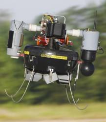
 T-Hawk MAV. Honeywell photo
A GPS-guided T-Hawk Micro Air Vehicle (MAV) more frequently used in combat reconnaissance missions in Iraq and Afghanistan is being used to help emergency efforts at Japan’s damaged fukushima Daiichi nuclear plant.
Weighing just 17 pounds and measuring 14 inches in diameter, the T-Hawk is a ducted-fan vertical takeoff and landing air vehicle originally developed in recent years by Honeywell Corporation under a $40-million Defense Advanced Research Projects Agency (DARPA) technology demonstration contract.
At the earthquake-damaged Fukushima Daiichi nuclear facility, three Honeywell pilots have flown four T-Hawks — adapted to carry radiation sensors as well as cameras — in successful missions to get up-close video and photos of the nuclear reactor inside the plant as emergency workers attempt to limit further radiation releases.
With more than 100 of the MAVs currently deployed in war zones in Iraq and Afghanistan, the T-Hawk features “hover-and-stare” capability that enables pilots to hold the unit in one place and zoom in on features inside the damaged reactors while the T-Hawk sends radiation data and still images back to recovery workers.
With its first flights initiated on April 15, the T-Hawk can also send live in-flight video feeds to help workers focus on critical areas. Pilots can adjust the MAVs’ direction mid-flight and control the cameras to alter angles and get better views of damaged equipment.
Because of its small size, the remotely operated T-Hawk can be flown into tight spaces where humans and other larger unmanned aerial vehicles (UAVs) such as the Global Hawk cannot go.
"The T-Hawk reminds us that innovative technologies initially created for defense purposes can find crucial roles in humanitarian and disaster recovery efforts," Tim Mahoney, president and chief executive officer of Honeywell Aerospace, said of the MAV’s use at Fukushima.
Navigation data are provided by 12-channel, Miniature PLGR Engine-SAASM (MPE-S) GPS receivers from Rockwell Collins.
T-Hawks are built at the Honeywell Defense and Space facility in Albuquerque New Mexico, where the MPE-S receivers, flight management unit, inertial measurement unit (IMU), and air data sensor system — the latter three all micromechanical system (MEMS) designs from the company’s facility in Ridgeway, Minnesota — are installed.


