Homeland Security Offers Free Testing for GPS Equipment
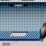
The Department of Homeland Security is offering to test GPS equipment used in critical infrastructure to see how resilient it is against spoofing.
The effort is part of the GPS Testing for Critical Infrastructure or GET-CI program supported by DHS’s Science and Technology Directorate.
By Dee Ann Divis