
The Time and the Place: Dawn
By astral definition, every dawn is new. In the human condition, we see its possibility, its growing brightness bringing hope. Or, in our best selves, we bring hope to it.
By Alan CameronGlobal Navigation Satellite Systems Engineering, Policy, and Design
By astral definition, every dawn is new. In the human condition, we see its possibility, its growing brightness bringing hope. Or, in our best selves, we bring hope to it.
By Alan Cameron
The United States Federal Aviation Administration’s (FAA) Wide Area Augmentation System (WAAS) uses Hexagon | NovAtel technologies, including reference receivers and signal generators, to provide the accuracy and integrity necessary to safely operate civil aircraft. Here’s a look at the updated technologies and how they enable GPS as a safety of life service for aviation.

The European GNSS Agency (GSA) has started testing the Open Service Navigation Message Authentication (OSNMA) feature in the Galileo signals.
By Inside GNSS
In 2018, when the UK’s post-Brexit involvement in Galileo was still a point of contention between London and Brussels, UK ministers set aside £92m to study the feasibility of building a sovereign satellite-navigation system. Almost immediately, the UK Space-Based Positioning Navigation and Timing Program (SBPP) became something of a political football, or soccer ball if you prefer. Critics and supporters chimed in vehemently at any piece of news. Why an independent UK PNT system might be necessary remains a reasonable first question for some observers.
By Peter Gutierrez
Huber+Suhner, a global supplier of optical and electricity connectivity solutions, updated its range of SENCITY Rail antennas to receive signals from all four GNSS: BeiDou, Galileo, GPS and GLONASS.
By Inside GNSS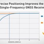
Swift Navigation announced that its precise positioning platform can improve the performance of existing single-frequency GNSS positioning, found on most production vehicles today, from the standard average of 3 meters to lane-level accuracy without changing existing hardware and antenna.
By Inside GNSS
Raytheon Missiles & Defense announced that its StormBreaker smart weapon has been approved for use on the F-15E by the U.S. Air Force’s Air Combat Command. StormBreaker’s multimode seeker guides the weapon by imaging infrared, millimeter wave radar, and semi-active laser in addition to or with GPS and inertial navigation system guidance.
By Inside GNSS
u-blox announced that it supplied the high-accuracy technology that made it possible to fly the world’s largest swarm of drones. The record-breaking simultaneous flight of 2198 miniature UAVs was launched into the night sky over Saint Petersburg, Russia, on September 3.
By Inside GNSS
The technology multinational GMV is playing a key role in the Galileo Second Generation (shortened to G2G) ground segment; Galileo is Europe’s global, civil, satellite-based navigation and positioning system.
By Inside GNSS
Spirent Federal Systems announced that it has been selected by the U.S. National Aeronautics and Space Administration (NASA) for testing GNSS for lunar exploration.
By Inside GNSS
The latest release from Hexagon promises precise point positioning (PPP) convergence in less than a minute for centimeter-level accuracy on land, air and marine applications around the world.
By Inside GNSS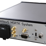
ANavS showcased its Multi-Sensor RTK Positioning Module with its modular and flexibly configurable sensor fusion software at the recent International VDI Conference Autonomous Trucks virtual conference.
By Inside GNSS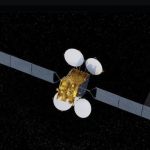
Korea will inaugurate its own satellite-based augmentation system (SBAS), the Korea Augmentation Satellite System (KASS), sometime in 2022, with signals broadcast over the East Asian region from adjunct payloads aboard two geostationary communications satellites.
By Inside GNSS