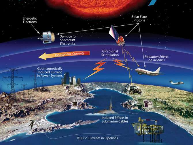
GNSS (all systems) Archives - Page 137 of 153 - Inside GNSS - Global Navigation Satellite Systems Engineering, Policy, and Design

GNSS (all systems)

July 28, 2011

GNSS Hotspots | July 2011

One of 12 magnetograms recorded at Greenwich Observatory during the Great Geomagnetic Storm of 1859
1996 soccer game in the Midwest, (Rick Dikeman image)
Nouméa ground station after the flood
A pencil and a coffee cup show the size of NASA’s teeny tiny PhoneSat
Bonus Hotspot: Naro Tartaruga AUV
Pacific lamprey spawning (photo by Jeremy Monroe, Fresh Waters Illustrated)
“Return of the Bucentaurn to the Molo on Ascension Day”, by (Giovanni Antonio Canal) Canaletto
The U.S. Naval Observatory Alternate Master Clock at 2nd Space Operations Squadron, Schriever AFB in Colorado. This photo was taken in January, 2006 during the addition of a leap second. The USNO master clocks control GPS timing. They are accurate to within one second every 20 million years (Satellites are so picky! Humans, on the other hand, just want to know if we’re too late for lunch) USAF photo by A1C Jason Ridder.
Detail of Compass/ BeiDou2 system diagram
Hotspot 6: Beluga A300 600ST

1. AQUARIUS
Buenos Aires, Argentina and Vandenberg AFB, California, USA

Read More >

By Inside GNSS
July 20, 2011

EC Official Adds Galileo, EGNOS Worries to FCC’s LightSquared-GPS Deliberations

European Geostationary Navigation Overlay Service (EGNOS). ESA illustration

Citing European Space Agency (ESA) studies that showed “harmful interference” to Galileo receivers operating up to 1,000 kilometers from LightSquared base stations, a European Commission (EC) official has told the Federal Communications Commission (FCC) about his “deep concerns” about the wireless broadband company’s terrestrial transmissions in the 1525–1559 MHz band next to L1 GNSS frequencies.

Read More >

By Inside GNSS
[uam_ad id="183541"]
July 11, 2011

GNSS-Based Attitude Determination

FIGURE 1: Heading, bank and elevation angles of an actual platform carrying two perpendicular two meter-long baselines. The attitude solutions are shown for both the derived, or float, measurements (top), as well as the carrier phase-based, or fixed, measurements obtained after having correctly resolved the integer ambiguities (bottom). Precision differs between the methods by two orders of magnitude. Gray dots represent the two-dimensional projections on each of the three coordinate planes.

Working Papers explore the technical and scientific themes that underpin GNSS programs and applications. This regular column is coordinated by Prof. Dr.-Ing. Günter Hein, head of Europe’s Galileo Operations and Evolution.

Read More >

By Inside GNSS

What is a virtual reference station and how does it work?

Q: What is a virtual reference station and how does it work?

A: To reach centimeter-level — or even better — accuracy of positioning typically requires use of precise dual-frequency carrier phase observations. Furthermore, these observations are usually processed using a differential GNSS (DGNSS) algorithm, such as real time kinematic (RTK) or post-processing (PP). Regardless of the specific differential algorithm, however, implicit in the process is an assumption that the quality of the reference station data is consistent with the desired level of positioning accuracy.

Read More >

By Inside GNSS

China Satellite Conference 2011

Hotel Nikko New Century in Haidian, Beijing

This officially sanctioned conference and equipment exhibtion addresses applications, technologies and trends for China’s satellite communications, broadcasting, remote sensing, navigation and positioning.It will be held at Hotel Nikko New Century in Beijing on October 26.28, 2011.

Subjects of most interest to Inside GNSS readers include:

Read More >

By Inside GNSS

Berlin GNSS Symposium 2011

Rathaus Wilmersdorf

The International Symposium on Global Navigation Satellite Systems, Space-based and Ground-based Augmentation Systems and Aplications will take place at the Wilmersdorf in Berlin on October 10 and 11. The event will be held in English.

This year, the focus is on EUPOS, a ground-based European GNSS augmentation system, and on the regional geodetic reference frames and systems, ground-based GNSS infrastructures and technical developments in the field of DGNSS.

Read More >

By Inside GNSS
[uam_ad id="183541"]
July 10, 2011

SIRGAS 2011

El Fortin monument in Heredia, Costa Rica

SIRGAS 2011,  the annual working meeting of the organization in charge of the geocentric reference system for the Americas, will be held in Heredia, Costa Rica from August 8 to 10.

It will take place in Clodomiro Picado Twight auditorium at the Omar Dengo campus of the National University of Costa Rica.

Read More >

By Inside GNSS

2011 East Coast Seminars: NavtechGPS

NavtechGPS will offer its 2011 east coast GNSS technical seminars at the Doubletree Hotel in Annapolis, Maryland from Monday, July 11 through Friday, July 15.

Over 25 years, NavtechGPS has organized basic and advanced GNSS seminars for engineers and technical professionals all over the United States and has provided GPS/GNSS applications solutions for military and research customers, with product choices from more than 30 manufacturers.

Read More >

By Inside GNSS
July 6, 2011

ESA International Summer School on Navigation Satellite Systems 2011

Galileo Test and Development Environment (iFEN photo)

The 2011 International Summer School on GNSS will take place July 20 to July 30 in Berchtesgaden, Germany at the GATE facility (Galileo Test and Development Environment).

This year’s theme is Towards a Mutli-Constellation Multi-Frequency GNSS and SBAS.

You may still  register online for the waiting list. (Link here for the summer school program. )

Read More >

By Inside GNSS
July 5, 2011

UAV-g 2011: Unmanned Aerial Vehicle in Geomatics

ETH Hönggerberg from the south (Hannes Röst photo)

The Swiss Federal Institute of Technology (ETH) sponsors this conference and exhibition on UAVs and geomatics at Campus Science City (Hoenggerberg) in Zurich, Switzerland from September 14 through 16, 2011.

UAV-g 2011 will bring together experts in photogrammetry, surveying, robotics, computer vision, artificial intelligence and aerospace engineering.

Researchers, developers, service and systems providers and users are invited to exhibit and demonstrate their UAV systems in geomatics at at the Birrfeld airfield on Thursday, September 15.

Read More >

By Inside GNSS
July 2, 2011

Cars on the Road!

FIGURE 1: System architecture

Cooperative vehicle safety applications should preferably have two-meter horizontal accuracy and six-meter vertical accuracy, all with a 95-percent availability. The solution must be developed to incorporate lower-cost sensor options, specifically, lower-cost inertial measurement units that can be generally characterized by the gyro drift of 100 degrees per hour and an accelerometer bias force of twice its mass times gravity (two milligals).

Read More >

By Inside GNSS
IGM_e-news_subscribe