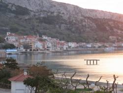
GNSS (all systems) Archives - Page 138 of 150 - Inside GNSS - Global Navigation Satellite Systems Engineering, Policy, and Design

GNSS (all systems)

United Arab Emirates GNSS Applications Workshop

Higher Colleges of Technology (HCT), Dubai

The United Nations International Committee on GNSS (ICG) and the U.S. State Department has organized a workshop on GNSS applications from Sunday, January 16 to Thursday, January 20, 2011, at the campus of the Higher Colleges of Technology in Dubai Academic City.

Read More >

By Inside GNSS
January 11, 2011

Topcon and DICKEY-john Form Alliance Around Ag System Development

Topcon X30 controller

Topcon Positioning Systems (TPS) and DICKEY-john Corporation, an agricultural systems and machine control manufacturer based in Auburn, Illinois, have formed a strategic relationship in the agriculture industry.

Headquartered in Livermore, California, TPS recently unveiled its System 350 machine control system, which employs the company’s new X30 control console and its AGI-3 receiver for autosteering.

Read More >

By Inside GNSS
[uam_ad id="183541"]
January 9, 2011

Differences between Signal Acquisition and Tracking

Q: Why is acquisition of GNSS signals generally more difficult than tracking and what are the limiting factors?

A: A fairly good analogy of the difference between GNSS signal acquisition and tracking can be found in the rescue of victims of a sunken ship whose location is not accurately known. The first stage of the rescue attempt typically involves an aircraft flying a search pattern, which hopefully encompasses the location where the ship went down.

Read More >

By Inside GNSS

Wavelets and Notch Filtering

FIGURE 1: Touching wavelet spectra

For the complete story, including figures, graphs, and images, please download the PDF of the article, above.

The use of GNSS for safety critical applications is gaining interest, particularly amongst aviation users, who probably have the most demanding requirements. The GNSS frequency band containing the Galileo E5 and GPS L5 signals is designated as an aeronautical radio navigation service (ARNS) band, which enjoys legal protection from other services not allocated to this frequency on a primary basis.

Read More >

By Inside GNSS

A Model-Based Approach

For the complete story, including figures, graphs, and images, please download the PDF of the article, above.

Galileo receiver designers require formal interface specifications for the Galileo signal-in-space (SIS) in order to write unambiguous and accurate specifications for Galileo receivers. To compute their positions, Galileo receivers must be able to retrieve timing and orbital information from the data stream conveyed in Galileo analog signals.

Read More >

By Inside GNSS

Indian Regional Navigation Satellite System

FIGURES 1, 2 & 3

For the complete story, including figures, graphs, and images, please download the PDF of the article, above.

In satellite navigation, a GNSS receiver must account for several sources of error such as relativistic effects, atmospheric propagation delay, offset of satellite clocks from system time and satellite ephemeris. In order to accurately compute user position, velocity, and time (PVT), these errors need to be predicted/estimated precisely.

Read More >

By Inside GNSS
[uam_ad id="183541"]

GNSS Interference, Detection and Mitigation

Bushy House

Britain’s Position, Navigation and Timing Network of the Digital Systems
KTN (Knowledge Transfer Network) presents a one-day workshop on
"GNSS Interference, Detection and Mitigation."

Professor Martyn Thomas will present the
conclusions of the Royal Academy of Engineering report on GNSS vulnerability, which was released on March 8.  

The workshop will take place at Bushy House, National Physical Laboratory, Teddington, Middlesex on Thursday, March 10 2011 from 10 a.m. to 4 p.m.

Topics include:

Read More >

By Inside GNSS
January 8, 2011

Natural Threats to GNSS Positioning

Bushy House

Britain’s Position, Navigation and Timing Network of the Digital Systems KTN (Knowledge Transfer Network) presents a one-day workshop on "Natural Threats to GNSS Positioning."

It will take place at Bushy House, National Physical Laboratory, Teddington, Middlesex on Wednesday, January 19 2011 from 10:00 a.m. to 3:30 p.m.

A number of natural phenomenon affect GNSS reliability and accuracy. These include:

Read More >

By Inside GNSS

2011 West Coast Seminars: NavTech GPS

NavTech GPS will offer its 2011 west coast GNSS technical seminars at the Doubletree Hotel in San Diego, California from Monday, March 28 through Friday, April 1.

Over 25 years, NavTech GPS has provided GPS/GNSS applications solutions for military and research customers, with product choices from more than 30 manufacturers, and has organized basic and advanced GNSS seminars for engineers and technical professionals all over the United States.

The San Diego seminars include:

Read More >

By Inside GNSS

GNSS Interoperability, or Can’t We All Just Get Along Together?

Simple harmonic motion

Return to "GNSS Year in Review"

At first glance, interoperability and its implication of at least some degree of cooperation seem at odds with the idea of competing GNSS systems.

Yet the mantra of compatibility, interoperability, and even — in the terminology of GPS pioneer Brad Parkinson —interchangeability has taken on a nearly unanimous harmony in the pronouncements and deliberations of GNSS leaders.

Read More >

By Inside GNSS

GNSS Year in Review: Three Trends That Matter

Yes, it’s that time — when we try to anticipate what 2011 holds for GNSS by analyzing (or just trying to remember) the highlights of the past 12 months in our global navigation satellite system industry.

First, 2010 was a busy year. Successful launches of 13 new satellites brought the number of GNSS spacecraft in orbit to more than 60. The highest level yet for both numbers launched and in the collective GNSS constellation.

Read More >

By Inside GNSS
IGM_e-news_subscribe