Cover Story Archives - Inside GNSS - Global Navigation Satellite Systems Engineering, Policy, and Design

Cover Story

September 19, 2017

Systemic Jamming

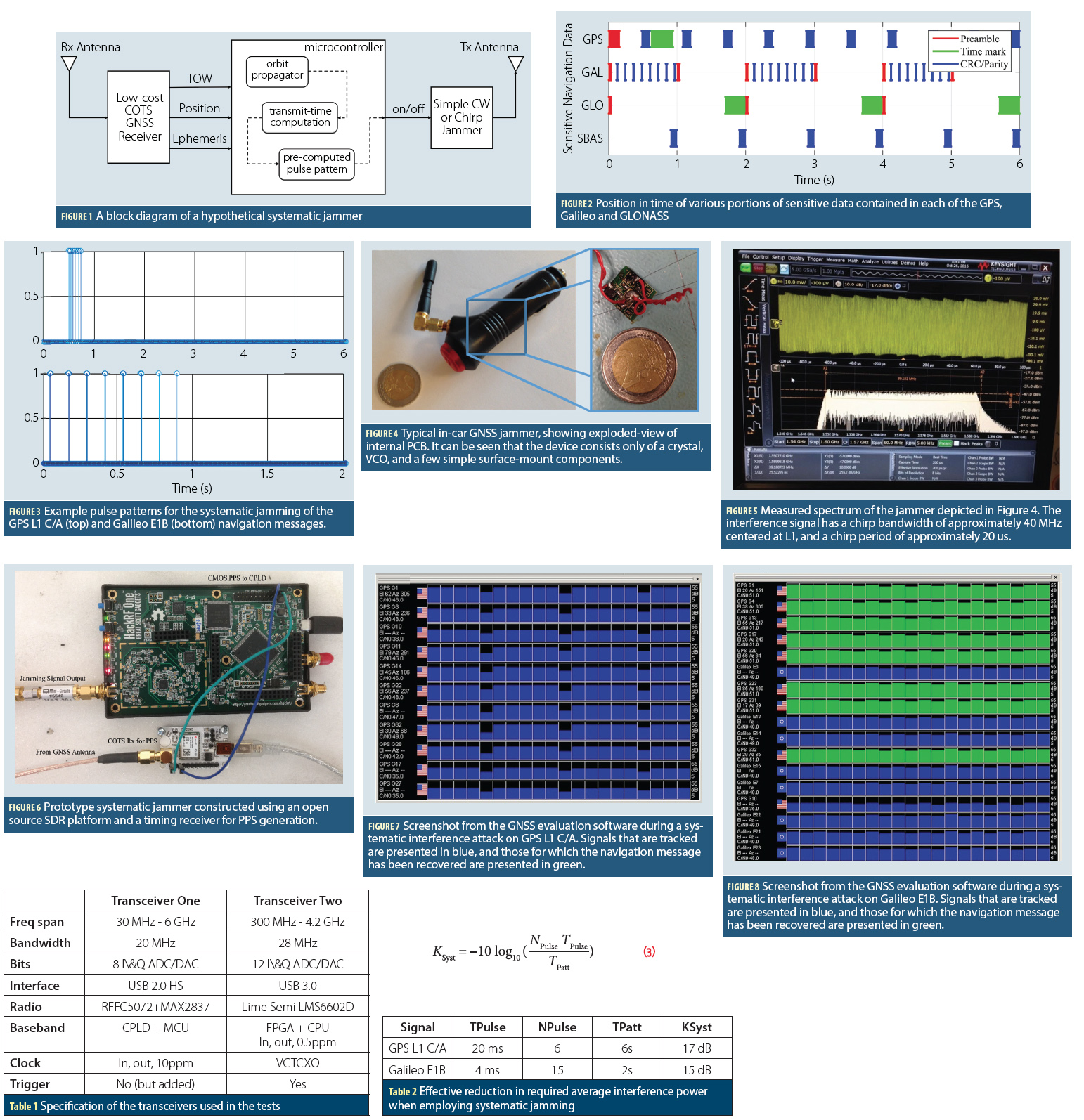
Figures 1 – 8, Tables 1 & 2, Equation 3

The vulnerability of GNSS to various forms of malicious interference have been widely discussed in recent years, and have considered a wide range of both real and potential attacks. Some of these have included extensive studies of commercially available jamming devices, while others have considered the more comprehensive case of spoofing, where the interference takes the form of genuine GNSS signals (For details, see papers listed in Additional Resources, including M. G. Amin et alia).

Read More >

By Inside GNSS
[uam_ad id="183541"]
April 1, 2017

GNSS for ERTMS Train Localization

Demo Test in Italy on Cagliari – Decimomannu line – February 24, 2017. From left: Josef Doppelbauer (Executive director of ERA – European Union Agency for Rail), Maurizio Gentile (Chief Executive Officer of RFI – Rete Ferroviaria Italiana), Jean-Pierre Loubinoux (Director General of UIC – the worldwide professional association representing the railway sector and promoting rail transport), Carlo des Dorides (Executive director of GSA).

Read More >

By Inside GNSS
January 24, 2017

Multi-Receiver GPS-Based Direct Time Estimation

Equations

Incorporation of real-time synchronized phasor measurements in the control of power grids can play an important role in maintaining the overall closed-loop stability of the power system. In the past, instability in the power grid caused disturbances ranging from small local perturbations to severe large scale blackouts as can be seen from Figure 1. Currently, the synchronization achieved in measurements collected using devices known as supervisory control and data acquisition (SCADA) is not robust enough for efficient monitoring the power grid.

Read More >

By Inside GNSS
November 13, 2016

Navigating in Space

Figures 1 & 2

Spacecraft in low Earth orbit (LEO), at altitudes below 3,000 kilometers, remain within the main Global Positioning System (GPS) signals’ Earth coverage. Spacecraft employing GPS at these altitudes enjoy signal availability and navigation and timing performance emulating that of terrestrial users.

Read More >

By Inside GNSS
September 1, 2016

Geolocation Privacy

Reasonable Expectations of Privacy and a discussion of privacy in the United States typically begins with the Fourth Amendment of the U.S. Constitution, which provides that “[t]he right of the people to be secure in their persons, houses, papers, and effects, against unreasonable searches and seizures, shall not be violated.” In U.S. v Katz, the U.S. Supreme Court found that this Fourth Amendment protection created an individual’s constitutional right to privacy.

Read More >

By Ingo Baumann
[uam_ad id="183541"]
July 17, 2016

Air Force Backs GPS OCX as Temporary Shutdown Looms

The Air Force is defending the new GPS ground system, taking a stand against naysayers in Congress and declaring through its actions an intent to stick with the Next Generation Operational Control System program (OCX) — at least for now.

The most public of these actions occurred June 30 when Secretary of the Air Force Deborah Lee James announced OCX would surpass by at least 25 percent the program’s estimated cost. She declared a critical Nunn-McCurdy breach, putting the program on a path to automatic cancellation.

Read More >

By Dee Ann Divis
May 19, 2016

GNSS Evolutions for Maritime

Trends for marine accidents show rising numbers and costs that are mainly associated with collisions and groundings. Research indicates that about 60 percent of these accidents are caused by human error. The majority of them could have been avoided by providing suitable input to the navigation decision-making process, according to a 2008 report by the International Maritime Organization (IMO) Marine Safety Committee. (See IMO 2008 in Additional Resources section near the end of this article.).

Read More >

By Günter W. Hein
March 18, 2016

How Privatizing Air Traffic Control Could Affect Satellite Navigation’s Role in Aviation

The satellite-based NextGen program is in trouble — no question about it.

The Federal Aviation Administration (FAA) air traffic modernization effort will likely cost triple its original $40-billion program budget and need an extra decade — until 2035 or beyond — to reach completion, according to 2014 testimony by Department of Transportation (DoT) Inspector General Calvin Scovel.

Read More >

By Dee Ann Divis
January 19, 2016

SBAS

ISRO’s GSAT-15 satellite before launch, with GAGAN navigation payload

GAGAN — India’s SBAS
Redefining Navigation over the Indian Region
Recognizing the potential benefits of satellite-based augmentation systems, India took the early initiative to create its own SBAS called GAGAN — GPS Aided Geo Augmented Navigation.

Read More >

By Inside GNSS
January 18, 2016

GNSS Satellite-Based Augmentation Systems

Working Papers explore the technical and scientific themes that underpin GNSS programs and applications. This regular column is coordinated by Prof. Dr.-Ing. Günter Hein, head of Europe’s Galileo Operations and Evolution.

With the support of the European Space Agency (ESA), a European team designed a frequency- and time-transfer process and validated its performance in a complex navigation test bed. This two-way time-transfer technology took advantage of the following:

Read More >

By Günter W. Hein

GAGAN — India’s SBAS

The GPS Aided Geo Augmented Navigation (GAGAN) system was developed by the Indian Space Research Organization (ISRO), together with Airports Authority of India (AAI), to deploy and certify an operational satellite-based augmentation system (SBAS). The system’s service area covers the Indian Flight Information Region (FIR), with the capability of expanding to neighboring FIRs. 

Read More >

By Inside GNSS
1 2 3 12
IGM_e-news_subscribe