Cover Story Archives - Page 2 of 12 - Inside GNSS - Global Navigation Satellite Systems Engineering, Policy, and Design

Cover Story

September 7, 2015

New Fiscal Year Begins with Unfinished GPS Business

Most folks look to a new year as an opportunity for fresh starts and new projects. For the GPS community, however, the October 1 start of the 2016 federal fiscal year (FY16) will likely be more about the hangover — that is, the issues that are hanging over into the next 12 months, unresolved.

At the top of that list of unfinished business are two system decisions: a go/no-go determination on whether the United States will build eLoran as the U.S. backup to GPS and deciding whether or not to choose a new contractor for the GPS III program.

Read More >

By Dee Ann Divis
June 29, 2015

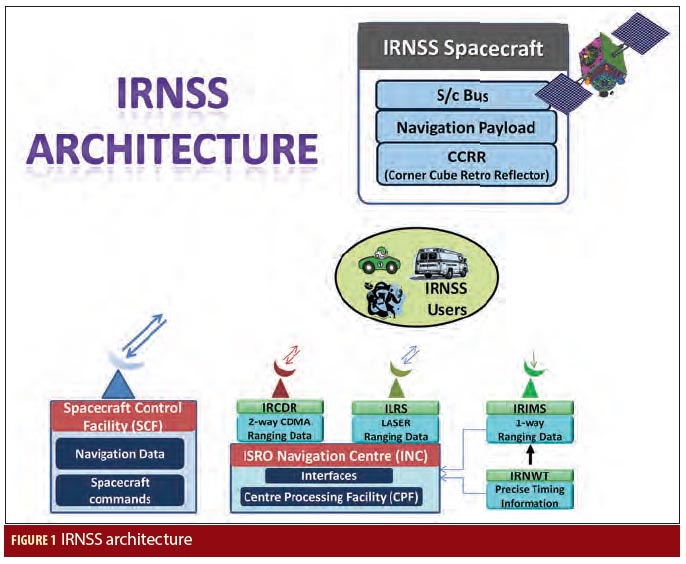
First Position Fix with IRNSS

Figure 1

The Indian Regional Navigation Satellite System (IRNSS) is an Indian Space Research Organisation (ISRO) initiative to build an independent satellite navigation system that provides precise position, velocity, and time (PVT) to users across the Indian region.

The primary objective of IRNSS is to achieve position accuracy of 20 meters (2σ) for dual-frequency users over India and the primary service area (a region extending to about 1,500 kilometers or 930 miles).

Read More >

By Inside GNSS
May 20, 2015

Thinking Small

Equations 2, 7, 8, 9, 10 & 11

Unmanned aerial vehicles (UAV) are finding increased application in both domestic and governmental applications. Small UAVs (maximum take off weight less than 20 kilograms) comprise the category of the smallest and lightest platforms that also fly at lower altitudes (under less than 150 meters).

Designs for this class of device have focused on creating UAVs that can operate in urban canyons or even inside buildings, fly along hallways, and carry listening and recording devices, transmitters, or miniature TV cameras.

Read More >

By Inside GNSS
[uam_ad id="183541"]
March 14, 2015

Expanding EGNOS Horizons

GPS+EGNOS tracking device able to use EGNOS OS and EDAS mounted on a container

The European Geostationary Navigation Overlay Service (EGNOS) has a European regional coverage that could be extended quite easily to areas adjacent to the European Union. Backed by the European Commission, a public/private consortium is operating programs of technical assistance to prepare nations in the Mediterranean region to adopt and exploit European GNSS services in their priority market segments, namely aviation and road freight transport/logistics.

Read More >

By Inside GNSS
January 16, 2015

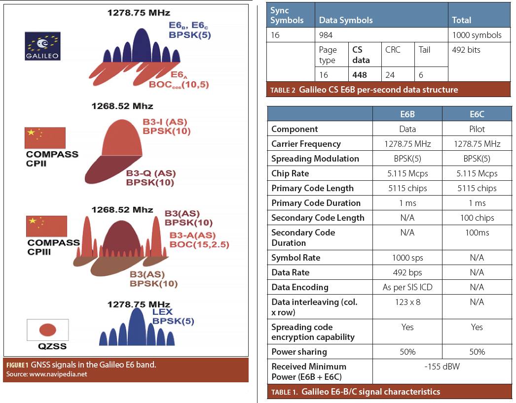
Galileo’s Commercial Service

Figure 1; Tables 1 & 2

After some years of concept studies and simulations, the Galileo Commercial Service is taking off. The journey has started toward what can be the most accurate and secure worldwide satellite-based navigation services for civil use.

Read More >

By Inside GNSS
August 8, 2014

Process In Place for Nearer-Term Commercial Operation of UASs

Special Report: UAS in the NAS

Clockwise from top left: A small drone rests on the ground during a demonstration in Florida, The Golden Eagle, a UAV developed at Clarkson University, takes wing, Nick Roy smiles at a drone in a lab at MIT, The Qube unmanned aerial vehicle by AeroVironment.

BY THE NUMBERS

Read More >

By Inside GNSS
[uam_ad id="183541"]
July 21, 2014

GPS Receiver Performance On Board a LEO Satellite

Equation 1

The small satellite “Technologie-Erprobungs-Träger 1” (TET-1) is the first spacecraft developed for the German Aerospace Center (DLR) On-Orbit-Verification (OOV) program, which provides flight opportunities dedicated to testing and qualification of new technologies in space. The satellite was lifted into a low-Earth orbit (LEO) on July 22, 2012, from the launch site in Baikonur, Kazakhstan.

Read More >

By Inside GNSS
IGM_e-news_subscribe