Frank Czopek’s Compass Points

Engineering Specialties
Mechanical space hardware, real-time embedded programming, Boolean Logic, Assembly Language.
His Compass Points
By Inside GNSS
Engineering Specialties
Mechanical space hardware, real-time embedded programming, Boolean Logic, Assembly Language.
His Compass Points
By Inside GNSS Antonio Tajani
Amid continuing debate over how to handle budgetary shortfalls in building a European GNSS, the European Space Agency (ESA) signed a €194 million ($270.5 million) contract on October 25 with SpaceOpal to provide space- and ground-based services to operate the Galileo constellation once it has been fully deployed.
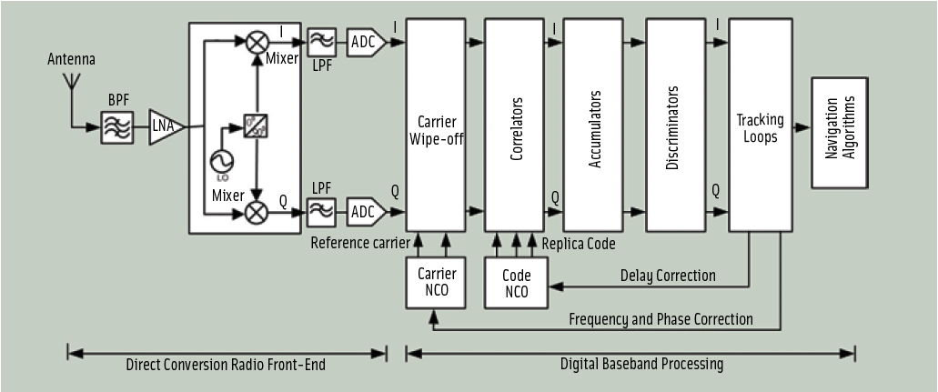
By Inside GNSS FIGURE 1: Block-diagram of a GNSS direct-conversion receiver
For the complete story, including figures, graphs, and images, please download the PDF of the article, above.
GNSS systems rely on direct sequence spread spectrum (DSSS) transmissions to achieve high receiver sensitivity. Typically, GNSS user equipment compares the signal received from a satellite with an internally generated replica of its corresponding code until the maximum correlation for a given delay is achieved. This provides an indirect measurement of the satellite-receiver range.
By Inside GNSSIt is not all about the satellites, of course.
And, despite the thrill of launches — the Fourth of July and every other national holiday celebration all grown up — it’s not about the rockets.
When evaluating the progress of GNSS programs, however, satellites and launches are a way to keep count — in fact, it is the way most of us do keep count.
By that measure, then, the numbers are adding up quickly.
By Inside GNSS FIGURE 1: Screenshot of RF simulation software showing GPS + GLONASS + Galileo constellations
In the first article in this series (Inside GNSS, July/August, 2010) we looked at the range of tasks that require GNSS signal simulation during design, manufacturing, certification, and maintenance of GNSS equipment. The second installment (Inside GNSS, September, 2010) described a range of simulation solutions.
In this final article, we try to find a simulation solution that best suits a particular task.
By Inside GNSSGNSS utilization of the S-band portion of the radio spectrum provides some challenges to designers of both GNSS navigation signals as well as signals used by other services, in terms of interference avoidance and signal power.
An important existing user of S-band spectrum is the Globalstar communications satellite system. The voice and data services provided by Globalstar employ the 2483.5–2500 MHz band for its satellite downlink communications to user terminals. Additionally, these satellites use multi-beam antennas to enable frequency reuse.
By Inside GNSSA completely GPS-based navigation solution is generally not feasible in GNSS signal–challenged environments such as urban canyons. However, even in these difficult environments a partial set of GPS signal measurements may still be available. For instance, one or two satellites are generally still visible even in dense urban canyons.
By Inside GNSSSuccessful launch of three Compass (Beidou-2) satellites so far this year and reports of another two planned later in 2010 have elevated awareness of China’s accelerating GNSS program.
Added to the two spacecraft placed in orbit in 2007 and 2009, that would bring the modernized Beidou constellation up to seven — halfway to the 13 or 14 satellites planned for the regional system scheduled to be available by 2012.
By Inside GNSSIn recent years, researchers have explored possible new allocations for Radio Determination Satellite Service (RDSS) and Radio Navigation Satellite Service (RNSS) spectrum from a regulatory point of view. These studies have mainly discussed S-band and C-band in addition to L-band.
The International Telecommunications Union (ITU) Radio Regulations define RNSS as a subset of RDSS. Although the allocations are differentiated — RDSS usually has a paired uplink — both can actually be used for satellite navigation.
By Inside GNSSQ: Is it possible to define a fully digital state model for Kalman filtering?
A: The Kalman filter is a mathematical method, purpose of which is to process noisy measurements in order to obtain an estimate of some relevant parameters of a system. It represents a valuable tool in the GNSS area, with some of its main applications related to the computation of the user position/velocity/time (PVT) solution and to the integration of GNSS receivers with an inertial navigation system (INS) or other sensors.
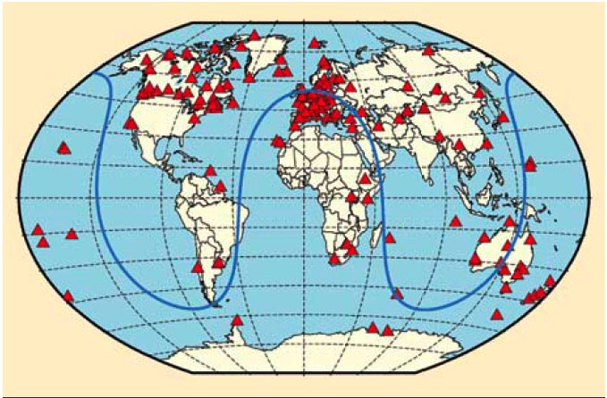
By Inside GNSS FIGURE 1: Geographical overview of the 170 IGS stations tracking SVN62/PRN25 during its current 90-day checkout period. The blue curve illustrates the ground track of the spacecraft on August 9, 2010.
For the complete story, including figures, graphs, and images, please download the PDF of the article, above.
On May 27, 2010, the U.S. Air Force successfully launched the first satellite of the Block II “follow-on” (Block IIF) series, the fourth generation of GPS spacecraft that features more precise and powerful signals, an extended design life, and several other technical advances.
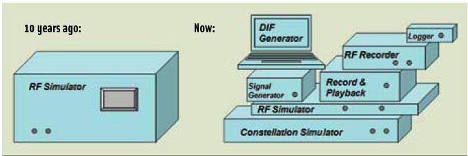
By Inside GNSS FIGURE 1: GNSS multi-channel signal simulator 10 years ago on its own (left) and with its ever-growing family (right)
For the complete story, including figures, graphs, and images, please download the PDF of the article, above.
In this article we describe the design and operation of a generic GNSS RF simulator. We also will look at the main types of GNSS RF simulators, their designs and specifics, their advantages and disadvantages.
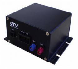
By Inside GNSS GINA On-Board Unit (OBU)
For at least the past two decades, managing traffic on Europe’s road networks has been a growing concern for European policy makers and citizens alike. While demand for transport has consistently increased over the years, Europe’s road network capacity has failed to keep pace, leading to increasing levels of congestion and pollution.
By Inside GNSS