Combined Architecture

Working Papers explore the technical and scientific themes that underpin GNSS programs and applications. This regular column is coordinated by Prof. Dr.-Ing. Günter Hein, head of Europe’s Galileo Operations and Evolution.
Global Navigation Satellite Systems Engineering, Policy, and Design
Working Papers explore the technical and scientific themes that underpin GNSS programs and applications. This regular column is coordinated by Prof. Dr.-Ing. Günter Hein, head of Europe’s Galileo Operations and Evolution.
NEO-M8P.jpg)
u-blox continues to roll out variations on its new generation of GNSS technology, launching the NEO-M8P receiver modules targeted at such applications as unmanned vehicles and robotic guidance systems
By Inside GNSS
On Wednesday, February 24, 2016, Inside GNSS, Inside Unmanned Systems, and u-Blox AG presented a free 90-minute web seminar continuing our exploration of GNSS positioning, navigation, and guidance for UAVs.
By Inside GNSS
SBAS and RNSS: The Unsung Heroes of GNSS
Okay, if I had wanted to pander to GNSS fans, I might have called this, “Making Great Greater.”
But there are only so many superlatives that can be lathered on this remarkable technology before simple praise turns into hagiography.
So, it’s time once more to give a little love to those unsung heroes of GNSS: the augmentations and regional navigation satellite systems.
By Inside GNSS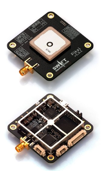 Swift Navigation’s Piksi GPS receiver
Having started out with a crowd source–funded launch through Kickstarter followed by two rounds of more conventional venture capital backing — $2.6 million in 2014 and another $11 million last December — San Francisco, California–based Swift Navigation is going after a low-cost, high-precision market such as unmanned aerial vehicles (UAVs) with its Piksi GPS receiver platform.
By Inside GNSS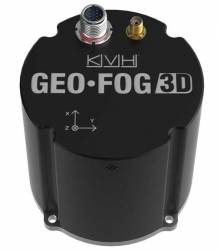
KVH Industries, Inc., has introduced the GEO-FOG 3D inertial navigation system (INS), targeting unmanned, autonomous, and manned aerial, ground, marine, and subsurface platforms, such as subsea remotely operated vehicles (ROV) or mining systems.
By Inside GNSS
The founders of Chronos and UrsaNav announced a new collaboration yesterday (December 3, 2015) intended enhance the resilience and reliability of space-based positioning, navigation, and timing (PNT) services.
By Inside GNSS Sunset in Sydney
The 9th International Symposium on Mobile Mapping Technology (MMT-2015) will take place from December 9 – 11, 2015 at The University of New South Wales in Sydney, Australia.
Online registration is available
By Inside GNSS
Stuart Riley was born and raised in Nottingham, England, where some of the crucial crossroads in his career appeared quite early.
One such inflection point came when he was just 10 or 11, and it involved a birthday present from his sister, Alison.
By Inside GNSS Forsyth Park, Savannah, Georgia
The IEEE/ION PLANS 2016: Position Location And Navigation Symposium will take place April 11-14 2016 at the Hyatt Regency Savannah in Savannah, Georgia.
Early bird registration ends March 10, 2016.
This biennial technical conference and industry exhibition explores the field of navigation — from fundamental research, to applications, to field test results.
By Inside GNSS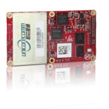 Unicore UR380 GNSS Receiver with UB380
Unicore released UB380 GPS/GLONASSS/BDS high precision board at ION GNSS+ 2015, held this week in Tampa, Florida.
UB380 is a 384-channel, multi-GNSS receiver that supports GPS, GLONASS, and the BeiDou Satellite System (BDS) based on Unicore’s multi-GNSS system on a chip. The receiver board can support GPS L1, L2, and L5; GLONASS L1, L2; and BDS B1, B2 and B3.
By Inside GNSS

"Precise Point Positioning, Part 2: A Deeper Dive" took place on April
14. Dr. Sanjeev Gunawardena, from the Air Force Institute of Technology,
and
Dr. Sunil Bisnath, of York University, led the discussion.
It was the second of two webinars on high-accuracy GNSS techniques of
real-time kinematic (RTK) and precise point positioning (PPP).
You can still register for free, on-demand viewing of a recorded version of the live event:
By Inside GNSSA Federal Register notice published yesterday (August 18, 2015) seeking comment on plans to shut down a large portion of the Nationwide Differential GPS (NDGPS) network marks the effective end of a program that spurred a hard-fought controversy in the era of Selective Availability (SA).
By Inside GNSS