PNT

November 22, 2021

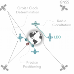
Evaluating LEO Constellations for Global Satellite Navigation Service

Low Earth Orbit (LEO) satellites are being launched regularly into space to create satellite constellations for a variety of purposes: communication, surveillance, providing Internet service and more. Global satellite navigation service is provided by satellites in higher orbits, mi-Earth orbit (MEO) roughly 25,000–27,00 kilometers above the Earth. Could satellites in LEO be used to provide global satellite navigation?

Read More >

By Inside GNSS
November 19, 2021

Inertial in the Field: Webinar Now Available On Demand

High standards for technology in the lab and in the factory are all very fine, but what matters most is how it works in industrial application. We take a close-up look at inertial measurement and inertial navigation in such real-world cases as
• oil and gas pipeline inspection,
• stabilization of optical camera platforms and
• autonomous cargo transport.

Read More >

By Inside GNSS
[uam_ad id="183541"]
November 18, 2021

Galileo Authentication Signal Open for Testing; First Results

A research team at the Fraunhofer Institute for Integrated Circuits (IIS) in Germany authenticated Galileo’s live Open Service Navigation Message Authentication (OSNMA) signal on November 16. The team used a GNSS receiver jointly developed with TeleOrbit GmbH, the compact GNSS Receiver with Open Software Interface (GOOSE).

Read More >

By Inside GNSS
November 13, 2021

Embedded Timing Solution for Third-Party Hardware

ADVA introduced its OSA 5400 SyncModule  embedded timing solution, enabling technology suppliers to  integrate precise synchronization into their hardware. The M.2 form factor module offers equipment vendors a way to simply and cost-effectively add crucial timing capabilities with key functionality into their switches, routers, open compute servers and other IT devices.

Read More >

By Inside GNSS
[uam_ad id="183541"]
October 13, 2021

GNSS, Inertial to Keep Scooters Off Sidewalks

A maker of electric scooters has developed a GNSS- and inertial-based technology to keep its own products off of city sidewalks. Bird, a provider of environmentally friendly electric transportation, announced a smart sidewalk protection technology developed in partnership with u-blox.

Read More >

By Inside GNSS
September 21, 2021

GNSS Foresight Heralds New Direction for Aviation, UAVs, Air Taxis and Entire PNT Industry

Spirent Communications has launched GNSS Foresight, a cloud-based solution that empowers GNSS users with advance knowledge about the strength and reliability of GNSS signals in exact locations within their operational areas. The service will have early application for aviation, unmanned and autonomous platforms, but Spirent VP Jeremy Bennington told Inside GNSS that its potential is far wider.

Read More >

By Inside GNSS
1 41 42 43 44 45 55
IGM_e-news_subscribe