
Low Earth Orbit (LEO) satellites are being launched regularly into space to create satellite constellations for a variety of purposes: communication, surveillance, providing Internet service and more. Global satellite navigation service is provided by satellites in higher orbits, mi-Earth orbit (MEO) roughly 25,000–27,00 kilometers above the Earth. Could satellites in LEO be used to provide global satellite navigation?
We examined the OneWeb LEO constellation and variations of that constellation to determine the minimum size of a LEO constellation needed to provide global satellite navigation service. We used two criteria to assess if the constellation provided global satellite navigation service:
• Did the position dilution of precision (PDOP) values meet the GPS constellation requirements?
• Were the average PDOP values of the LEO constellation less than or equal to current GPS constellation average PDOP values?
From our modeling and simulation, we determined the minimum OneWeb LEO constellation sizes needed to satisfy these two criteria. We did not assess how these LEO satellites would be controlled, how their timing would be synchronized, nor other details of how to make the constellation perform as a stand-alone satellite navigation constellation. Table 1 summarizes current LEO constellations.
LEO constellations typically consist of more satellites than MEO or geosynchronous orbit (GEO) constellations because LEO satellites have smaller footprints compared to MEO or GEO satellites. LEO satellites also have a significantly shorter orbital period, passing over the earth with a mean motion of 0.06°/s compared to MEO satellites mean motion of 0.008°/s. This faster motion can be an advantage over MEO satellites because it leads to greater multipath rejection of satellite signals. LEO satellites usually transmit stronger signals. In a denied or degraded GPS signal environment, these stronger signals become an important asset.
LEO Performance
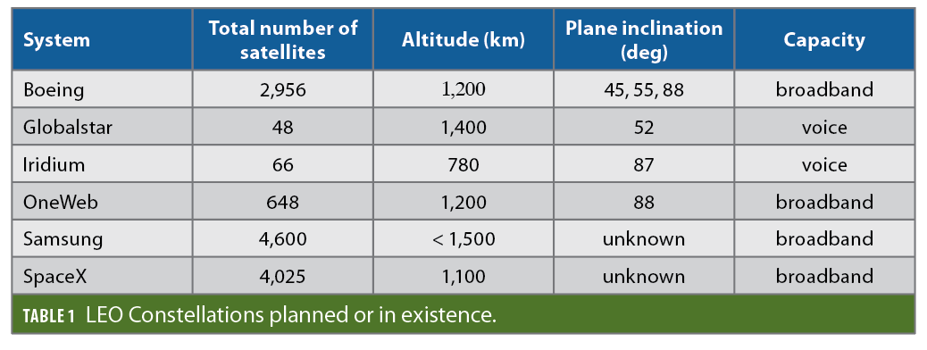
For our analysis, we focused on GPS performance as determined by PDOP values. For comparing the PDOP values of the GPS constellation with PDOP values of LEO constellations, we determined average PDOP values. We examined PDOP values by degrees of latitude over several months of 2019 and found a great variation in average PDOP values during the summer months of 2019 (likely due to new GPS III satellites being placed into orbit and replacing older GPS satellites).
We found that once the changes to the GPS constellation were completed, the average PDOP values, for the November 2019 through January 2020 average PDOP values were very consistent as shown in Figure 1.
GPS Performance Requirements
Civil GPS signal requirements are spelled out in the U.S. Department of Transportation’s Global Positioning System Civil Monitoring Performance Specification (U. S. DoT 2009). Paragraph 3.1.7 states that “civil monitoring shall verify that:
• the percentage of time the constellation’s global PDOP value is 6 or less is greater than or equal to 98% within the service volume over any 24-hour interval, and
• the percentage of time the constellation’s worst site PDOP value is 6 or less is greater than or equal to 88% within the service volume over any 24-hour interval.”
A LEO constellation that satisfies the service performance standards for PDOP may not provide the positioning accuracy users are accustomed to because the average PDOP values obtained from GPS are usually less than 2 (per our simulations). To provide comparable GPS-like global satellite navigation service, we imposed an additional requirement that the average PDOP values of the LEO constellation, by latitude, be equal to or less than the average PDOP values of the GPS constellation, by latitude, at latitudes between 60° north and 60° south latitude around the globe.
There is no requirement in either standard or specification for a specific number of satellites to be in view at a location or over a specified period of time. To compute a position solution using GPS, a minimum of four satellites must be in view to solve four equations involving four unknowns. Although we did not determine the number of satellites in view, a minimum of four satellites must be in view for the GPS Interference And Navigation Tool (GIANT) model to compute the PDOP values. A constellation that satisfies the formal PDOP requirements will have a minimum of four satellites in view at each site and time when PDOP values are computed.
Assessing LEO Constellation Performance
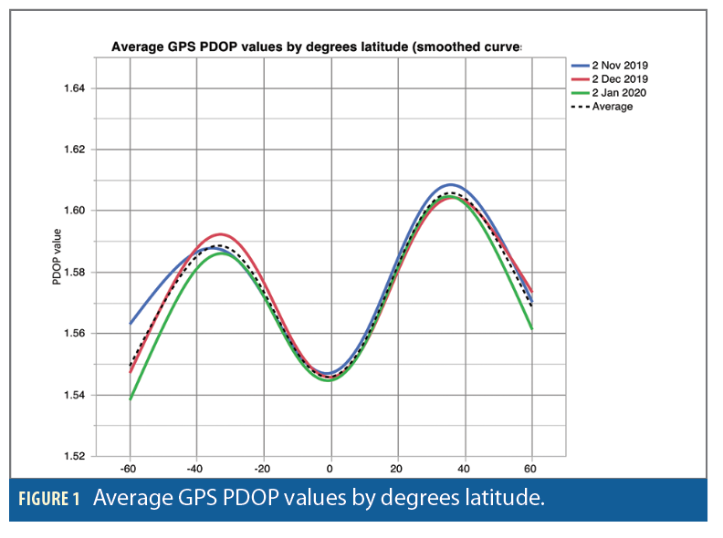
For our assessment of LEO constellation performance, we created several models with our GIANT software using the basic configuration of the OneWeb proposed constellation. We created ten LEO constellations of various sizes and performed simulations of those models using GIANT to assess the PDOP values and the number of satellites in view. We used the basic configuration of the OneWeb constellation (87.9° inclination, 18 orbital planes, and satellites evenly distributed in each orbital plane) but varied the number of satellites per orbital plane to determine the minimum constellation size required to meet the PDOP requirements for global satellite navigation. By varying the number of satellites, we assessed constellations of 90, 108, 126, 144, 162, 180, 198, 216, 234, and 360 satellites. The constellations assessed are listed in Table 2.
For each constellation listed in Table 2, the planes were spaced 10 degrees apart in their Right Ascension of the Ascending Node (RAAN) and evenly distributed over the Earth. Satellites in adjacent planes were offset from each other by 10°. We began our modeling and simulation with a OneWeb constellation of 720 satellites and then modeled the half-constellation of 360 satellites and the quarter-constellation of 180 satellites. Based on the PDOP results of the quarter-constellation, we then varied the constellation size by adding or subtracting one satellite in each orbital plane to assess PDOP results in several constellations.
Simulations
We used GIANT to create our LEO and GPS constellation models and perform the simulations. GIANT was created in 1996 to support a navigation warfare analysis of alternatives. GIANT is owned by the U.S. Department of Defense; it is a constructive, deterministic mission/engagement level modeling and simulation tool that can be used to predict the performance of a GNSS and alternative and complementary position, navigation, and timing system performance in an electronic warfare environment.
The GIANT modeling software has been continually updated and refined over the years and has been verified and validated against chamber-generated and field-collected data. GIANT is currently in use throughout the DoD by both government and industry personnel and is also used by foreign mission partners for modeling and simulation.
With GIANT, we built our LEO constellation models and performed ten simulations of each model, over a period of 109 minutes, to assess the PDOP values. We used the PDOP value as the primary performance characteristic to determine the number of LEO satellites required to provide GPS-like performance. We ran our simulation for 109 minutes instead of the normal 24-hour interval because OneWeb’s satellites complete an orbit in approximately 109 minutes versus the approximately 12 hours for GPS satellites to complete an orbit.
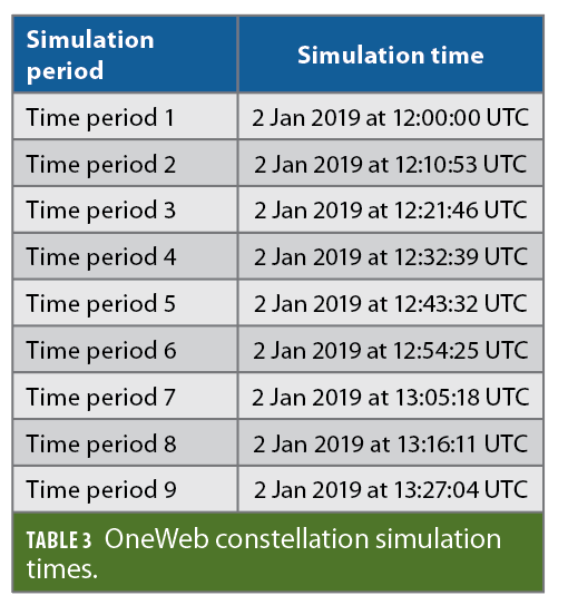
We collected data from 468 locations around the globe, each separated by 10° latitude and 10° longitude between 60° N latitude and 60° S latitude. The simulations were performed on January 2, 2019 starting at 12:00:00 UTC. Table 3 shows the times used to simulate the performance of OneWeb’s constellation based on its orbital periods.
Comparing PDOP to GPS Requirements
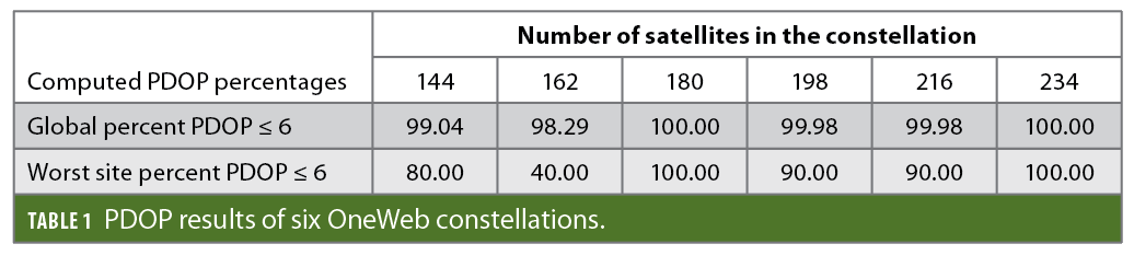
We followed the methodology used by Renfro et al. (2017) to compute the global PDOP value and the worst case PDOP value to determine which LEO constellations met the formal GPS PDOP standard. We computed PDOP values for the 468 locations for the ten simulation times. For the global PDOP percentage, we calculated the number of computed PDOP values (out of 4680) that were less than or equal to 6; the results are shown in the first row of Table 4.
To compute the worst site, we identified one or more sites out of the 468 sites with the greatest number of PDOP values that were greater than 6. We considered these the worst sites and determined, at that site, the percent PDOP less than or equal to 6. Our results are listed in Table 4.
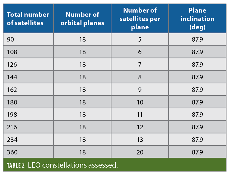
Table 4 shows that a LEO constellation with a minimum of 180 satellites is needed to meet the PDOP requirements of the GPS constellation. Constellations larger than 234 satellites, such as constellations of 360 and 720 satellites, not listed in Table 4, also meet the PDOP requirements.
Figure 2 shows graphically that LEO constellations of less than 144 satellites exhibit PDOP values that far exceed the PDOP ≤ 6 requirement (the 98% requirement and the worst site requirement are not shown graphically). A PDOP value of 6 is shown by the black dashed line in Figure 2. A minimum constellation of 144 LEO satellites is needed for an average PDOP ≤ 6 (an average PDOP ≤ 6 is not a service performance standard) but, as shown in Table 4, a constellation of 144 satellites does not satisfy the worst site requirement.
Comparing PDOP to GPS Average Values
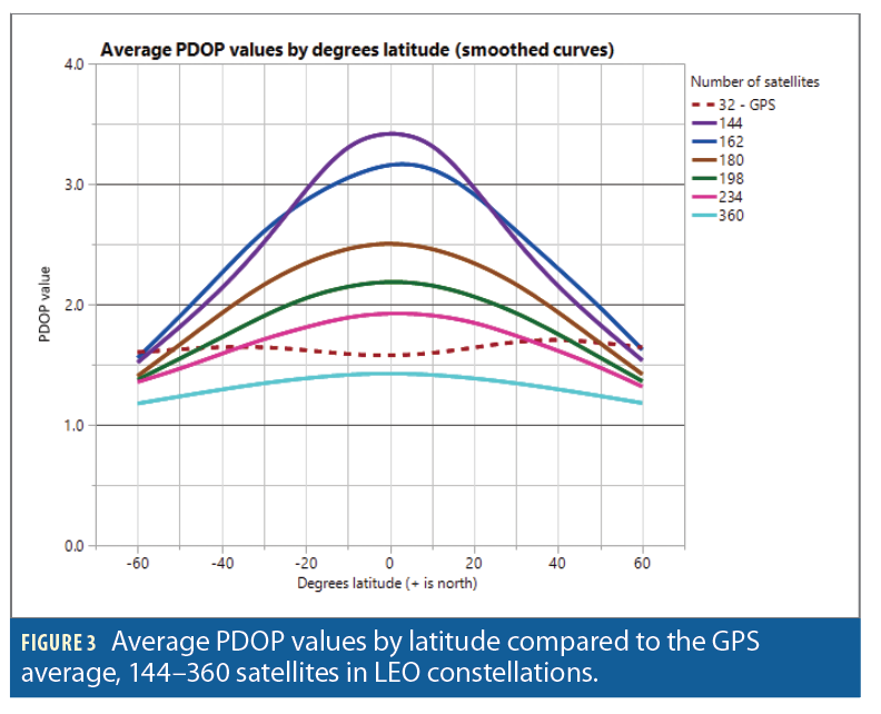
We used a GIANT model and simulations to compute average PDOP values for the GPS constellation as it existed in November 2019, December 2019, and January 2020. We then compared the average PDOP value of multiple LEO constellations at each latitude to the average GPS PDOP value at that latitude. These results are shown graphically inFigure 3. In Figure 3, the average PDOP values of the GPS constellation (November 2019—January 2020) are shown by the dark red dashed line.
Only a LEO constellation of 360 satellites, as shown in Figure 3, satisfied our requirement that the average PDOP values, by latitude, be equal to or less than the average GPS PDOP values by latitude. Potentially constellations of 342 (19 satellites each in 18 orbital planes) and 324 (18 satellites each in 18 orbital planes) LEO satellites could also provide comparable global navigation services; unfortunately we did not model these constellations. We also determined that a LEO constellation of 234 satellites would provide comparable PDOP values—and positioning accuracy—above 30° latitude and that below 30° latitude the decrease in positioning accuracy might be acceptable to users who don’t need pinpoint accuracy of their position.
Analysis
To meet the formal government PDOP requirements, a minimum LEO constellation of 180 LEO satellites is required (as shown in Table 4). Although a constellation of 180 LEO satellites meets the basic requirements of the Standard Positioning Service Performance Standard, the average PDOP values of the 180 LEO satellite constellation are greater than the average PDOP values currently obtained from the GPS constellation, shown in Figure 3 as the red dashed line.
For comparable PDOP values and the resulting positioning accuracy currently available from the GPS constellation, a constellation of 360 LEO satellites is needed as shown in Figure 3. We did not evaluate a constellation of 342 LEO satellites (19 satellites each in 18 orbital planes) or a constellation of 324 LEO satellites (18 satellites each in 18 orbital planes), which could possibly exhibit average PDOP values less than the GPS constellation around the globe. As shown in Figure 3, a constellation of 234 LEO satellites will provide comparable GPS accuracy at locations between 40° and 60° north latitude and 40° and 60° south latitude.
Future Work
Many other aspects of a LEO constellation should be examined to determine its suitability to provide satellite navigation service. Future work should look at the impact of the faster orbital speed on GPS receiver acquisition and tracking of those satellites; satisfaction of Age of Data requirements in the Standard Positioning Service Performance Standard; and satisfaction of position and time accuracy standards in the Service Performance Standard. Future work should also analyze the ability of a LEO constellation to meet Precise Positioning System Performance Standards for DoD use of a LEO constellation for positioning, navigation, and timing.
Conclusions
Through modeling, simulation, and analysis, we have shown that a LEO constellation of satellites could be used to provide global navigation services with comparable PDOP values. The accuracy of the computed position, a function of the PDOP value at the position or location, is a function of the number of satellites in a LEO constellation. Global satellite navigation services, with diminished accuracy compared to the current GPS constellation, can be provided with a minimum of 180 LEO satellites in 18 orbital planes (all at an inclination of 87.9°) with 10 satellites in each plane. We consider this the bare minimum for providing global navigation services. For global navigation services comparable to what is provided by the current GPS constellation, we determined that 360 LEO satellites in 18 orbital planes (all at an inclination of 87.9°) with 20 satellites in each plane are needed.
Authors

Charles F. Vaughan is an Operations Research Analyst who recently retired from the Air Force Research Laboratory. He has a Ph.D. in engineering from New Mexico State University.

Abu B. Kebbie-Anthony is a Ph.D. candidate in Mechanical Engineering at the University of Maryland- College Park. He earned his M.S. in Mechanical Engineering from the University of Maryland.


