European researchers have obtained laser range measurements of 1.5-centimeter accuracy to GIOVE-A, the first element in the Galileo In-Orbit Validation phase. The observations were made through collaboration between the UK Space Geodesy Facility (SGF), Surrey Satellite Technology Limited (SSTL), and the European Space Agency (ESA). The SGF is operated by the UK Natural Environment Research Council, with support from the British National Space Centre and the Ministry of Defence.
European researchers have obtained laser range measurements of 1.5-centimeter accuracy to GIOVE-A, the first element in the Galileo In-Orbit Validation phase. The observations were made through collaboration between the UK Space Geodesy Facility (SGF), Surrey Satellite Technology Limited (SSTL), and the European Space Agency (ESA). The SGF is operated by the UK Natural Environment Research Council, with support from the British National Space Centre and the Ministry of Defence.
The SGF satellite laser ranging system at Herstmonceux, East Sussex, made the range measurements on April 8. The facility had been invited to attempt observations by SSTL, the prime contractor that built the GIOVE-A space vehicle launched from Kazakhstan’s Baikonur space center on December 25, 2005.
At the time of acquisition, GIOVE-A was more than 25,000 kilometers distant from the station, the furthest distance ranged by the facility. GIOVE-A orbits the Earth at a height of more than 23,000 kilometers, some 3,000 kilometers above the GPS and GLONASS satellites that SGF regularly observes.
In order to track the satellite from Herstmonceux, predictions of its path based upon its transmitted navigational signals were supplied to SGF by the GIOVE Processing Centre located at ESA ESTEC, The Netherlands. The predictions were sufficiently accurate for the sunlit image of the satellite to be detected at night by the system’s high intensity camera and allowed the observer to direct short laser pulses towards it.
Laser Ranging
The satellite laser ranging (SLR) technique uses small astronomical telescopes to emit short pulses of laser light towards specially equipped spacecraft and to detect those photons that are reflected back. The times of emission and reception are recorded to an accuracy of a few picoseconds such that the range to the satellite can be deduced from the measured time of flight to a precision of better than one centimeter. The satellites tracked by this technique are equipped with an array of quartz cube-corner reflectors that closely return to source the incoming laser pulses.
The technique is weather dependent as skies have to be fairly cloud-free, but measurements are carried out both during daytime and at night. The key to success in extracting signal from noise is narrow-band spectral filtering in the return optical path and spatial filtering through a range gate technique that arms the detector only a few tens of nanoseconds before the expected arrival time of returning photons. During the satellite pass the time of flight inferred from every detected event is compared to the expected time of flight to the satellite and back.
A plot against time is built up of these observed-computed values, where true returns appear as a correlated track amongst the sky-noise events. Post processing extracts the real events, which are made available to the analysis community a few minutes after the end of the observations.
Unlike the microwave signals used by GNSS, the propagation time of laser light is not affected by the ionosphere; the tropospheric delay, amounting to a zenith range correction of two meters, can be estimated to millimeter accuracy using atmospheric mapping functions and local meteorological data. This lack of dependence of propagation delay on the variable effects of the ionosphere makes laser ranging a very strong technique for high-precision terrestrial reference frame (TRF) determination.
Laser range observations of a series of geodetic satellites, high-density small spheres encrusted with retro-reflectors and orbiting the Earth at heights of from 800 to 19,000 kilometers, are routinely used to monitor tiny changes in the location of the center of mass of the Earth, the origin of the TRF, that are driven by mass redistributions within the Earth system.
The technique is also used in precise orbit determination of Earth-observation altimeter and SAR satellites, complementing on-board tracking systems such as GPS and DORIS. This work and the operation of the worldwide network of SLR stations is coordinated by the International Laser Ranging Service (ILRS, http://ilrs.gsfc.nasa.gov/).
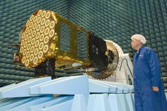
The GIOVE-A satellite is equipped with 76 quartz corner-cube retro-reflectors in an array to one side of its base, which is taken from the ESA document “Specification of GALILEO and GSTB-V2 Space Segment Properties Relevant for Satellite Laser Ranging, ESTEC, November 2005.”
During the design phase of the satellite, discussion took place among SSTL, ESTEC, and SGF in order to use SGF’s previous experience of ranging to the navigational satellites to help understand the difficulties and inform the choice of numbers of cubes to deploy, within available space and weight constraints, to enable a realistic link budget. For comparison, the two GPS satellites that are fitted with retro-reflectors have an array of only 32 cubes, and the newest GLONASS satellites have about 130 cubes.
The higher altitude of GIOVE-A reduces the return signal, which varies as the fourth power of the range, by some 55 percent relative to the signal from a GPS satellite; so, the greater number of cubes on GIOVE-A should ensure a return signal that is about 30 percent better than that from the GPS satellites, which from SGF’s Herstmonceux SLR facility are difficult targets.
SLR Results
Observations from Herstmonceux tend to support this analysis, with the Galileo laser return rate estimated at about 4 percent on average over the one-hour session; for the GPS satellites the rate is about 2 percent, and for GLONASS closer to 10 percent.
We can also use the laser range observations to estimate the accuracy of the predictions supplied by the GIOVE Processing Centre located at ESTEC. The differences between the observed and computed ranges imply that the predictions were accurate to about two or three kilometers, the major error being in the along-track direction.
Previous studies carried out by SGF and others have used laser range observations from the global network of ILRS stations to measure the quality of GPS and GLONASS orbits that are computed by the International GNSS Service (IGS, http://igscb.jpl.nasa.gov/). The laser ranging technique is a powerful, independent method of testing the accuracy of these orbits, which are determined from continuously transmitted navigational signals.
Given knowledge of the accurate location of the retro-reflector arrays on the satellites, SGF uses the laser range measurements to determine at a level of accuracy of better than one centimeter the radial distance to the satellite center of mass. The results suggest that the IGS orbits for GPS and GLONASS have an RMS radial accuracy of better than five centimeters and, interestingly, that there appears to be a radial bias in the IGS orbits of a few centimeters, in the sense that the IGS-determined orbits appear too big.
SGF and other researchers expect to use a similar technique to test the quality of any available precise orbital information derived from the GIOVE Processing Centre. In addition, once laser range data from the global network is available, it will be possible to determine SLR-only satellite orbits, which will further assist on-board clock characterisation in flight.
For figures, graphs, and images, please download the PDF of the article, above.


