system infrastructure/technology Archives - Inside GNSS - Global Navigation Satellite Systems Engineering, Policy, and Design

system infrastructure/technology

January 23, 2017

Positioning Technology in Australia Gets a $12 Million Boost

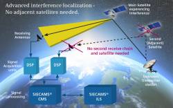
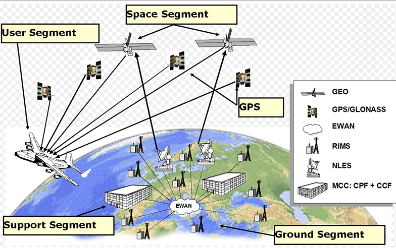
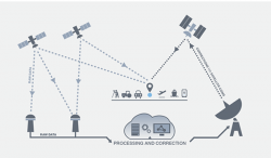
SBAS illustration with the GNSS satellites (upper left) and the communications satellite (upper right).

With the Australian government’s announcement earlier this month that it would invest $12 million in a two-year program looking into the future of positioning technology in Australia, comes plans for testing of satellite based augmentation systems (SBAS) to be undertaken, and for future applications for all four major modes of transport in Australia, as well as for potential safety, productivity, efficiency and environmental benefits.

Read More >

By Inside GNSS
December 13, 2016

Air Force Approves Lockheed Martin’s GPS Ground Control Design

GPS III satellites in production. Image Source: Lockheed Martin.

The U.S. Air Force has approved Lockheed Martin’s current GPS satellite ground control system upgrade to enable it to operate with more powerful and accurate GPS III satellites, the company said.

The Air Force’s Critical Design Review (CDR) for the Contingency Operations (COps) contract, completed on November 17, allows Lockheed Martin to proceed with the modification of the existing Architecture Evolution Plan (AEP) Operational Control Segment. The AEP, maintained by Lockheed Martin, controls the 31 GPS IIR, IIR-M and IIF satellites in orbit.

Read More >

By Inside GNSS
[uam_ad id="183541"]
December 1, 2016

Lockheed Martin Advances GPS Ground Control System for U.S. Air Force

The Air Force’s Global Positioning Systems Directorate contracted the CUP2 upgrade.

Lockheed Martin has announced a major upgrade to modernize the GPS ground control system, the company said. The commercial-off-the-shelf (COTS) upgrade no. 2 (CUP2) project, which became operational in mid-October to manage the 31 GPS satellites, is the latest step in the U.S. Air Force’s plan to refresh technology and transform the legacy operational control segment, also known as the Architecture Evolution Plan (AEP), the company said.

Read More >

By Inside GNSS
November 16, 2016

NOAA Expands GNSS Data Sources for Weather Prediction

The National Oceanic and Atmospheric Administration (NOAA) will purchase data from small commercial satellites to expand its GNSS radio occultation (RO) efforts to better predict weather.

In September NOAA, through the government’s Commercial Weather Data Pilot program, awarded contracts to San Francisco, California-based Spire Global ($370,000) and GeoOptics ($695,000), of Pasadena, California, to provide RO data. This data will be used to assess whether commercially provided information can be incorporated into the agency’s weather models.

Read More >

By Inside GNSS
December 2, 2014

Intelligent Transportation Systems: 22nd ITS World Congress

The Convention Centre Bordeaux

The 22nd World Congress and Exhibition on Intelligent Transport Systems and Services will be held at the Convention Centre Bordeaux and Exhibition Centre Bordeaux in Bordeaux, France on October 5 – 9, 2015. It will focus on how achieving intelligent mobility will change our lives, and the benefits space can bring to ITS applications.

The theme for this year’s event is “Towards Intelligent Mobility – Better Use of Space”, and will offer Plenary, Executive, Technical/Scientific, Special Interest and Interactive Sessions.

Read More >

By Inside GNSS
January 22, 2014

Won’t Get Fooled Again

How many times, as some once-promising politician stumbles up against his pull date, have we heard that irreverent anthem of The Who invoked?

Thousands? Millions?

Yes, back in the wreckage of the second George Bush’s second term, Barack Obama looked pretty good by comparison. Even then, though, raising the banner of “Hope” before the eyes of a desperate nation was a risky thing to do.

Read More >

By Inside GNSS
[uam_ad id="183541"]
January 19, 2014

Ionospheric Scintillation

Ionospheric scintillations are rapid temporal fluctuations in both amplitude and phase of trans-ionospheric GNSS signals caused by the scattering of irregularities in the distribution of electrons encountered along the radio propagation path. The occurrence of scintillation has large day-to-day variability. The most severe scintillations are observed near the poles (at auroral latitudes) and near the equator (within ± 20 degrees of geomagnetic equator).

Read More >

By Inside GNSS
March 12, 2013

ESA Achieves First Galileo-Only 3D Position Fix

Measurements of individual Galileo horizontal position fixes performed for the first time using the four Galileo satellites in orbit plus the worldwide ground system between 1000 and 11:00 CET on Tuesday 12 March 2013, showing an overall horizontal accuracy over ESTEC in Noordwijk, the Netherlands, of 6.3 meters. ESA figure

The European Space Agency (ESA) has announced a key milestone today (March 12, 2013) in the development of Europe’s GNSS program: the first determination of a ground location using the four Galileo satellites currently in orbit together with the system’s ground infrastructure.

This fundamental step confirms the Galileo system works as planned, according to ESA scientists.

Read More >

By Inside GNSS
1 2 3 12
IGM_e-news_subscribe