September 19, 2017

How do you use GNSS to compute the attitude of an object?
Q: How do you use GNSS to compute the attitude of an object?
By Inside GNSSGlobal Navigation Satellite Systems Engineering, Policy, and Design
Q: How do you use GNSS to compute the attitude of an object?
By Inside GNSS
After several years of shifting plans the competition to build the next tranche of GPS III satellites is poised to start, though the context in which that contest will take place has changed markedly from when planning first began.
By Dee Ann Divis
 Bernhard Richter, Leica Geosystems GNSS business director
 Enrico Salvatori, Qualcomm Europe
 Carlo Bagnoli, STMicroelectronics
Multinational semiconductor and telecommunications company Qualcomm is a world leader in the design and marketing of 3G, 4G and next-generation wireless technologies. Headquartered in San Diego, California, Qualcomm has been widening its footprint in the Europe, Middle East and Africa (EMEA) region, with a core focus in Europe.
“We expect to grow Qualcomm’s presence in Europe, becoming a major EU (European Union) player in the digitization of European industries,” said Qualcomm senior vice president and president of Qualcomm Europe, Enrico Salvatori.
By Inside GNSS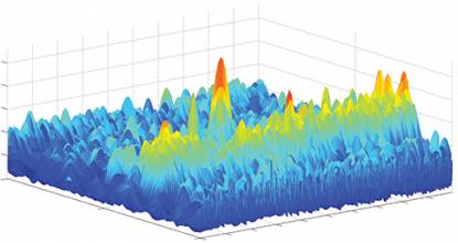
 Equations
GNSS is the technology of choice in most applications due to its dedicated infrastructure, Earth coverage, medium to high accuracy, and large market penetration. Most of the applications, including those we download on our smartphones, are in the category of Location Based Services (LBS). However, there are many other services and businesses that rely heavily on GNSS performance and reliability. For instance, Intelligent Transportation Systems (ITS) make extensive use of GNSS technology and this dependence will only grow in the future.
By Inside GNSS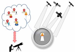
 Table 1
Working Papers explore the technical and scientific themes that underpin GNSS programs and applications. This regular column is coordinated by Em. Univ.-Prof. Dr.-Ing. habil. Dr. h.c. Guenter W. Hein.
This is the first article in a series. For Part 2: Hybrid- and Non-GNSS Localization, see here.
By Günter W. Hein
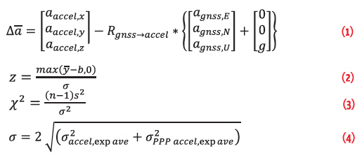
 Figures 1 – 8, Tables 1 & 2, Equation 3
The vulnerability of GNSS to various forms of malicious interference have been widely discussed in recent years, and have considered a wide range of both real and potential attacks. Some of these have included extensive studies of commercially available jamming devices, while others have considered the more comprehensive case of spoofing, where the interference takes the form of genuine GNSS signals (For details, see papers listed in Additional Resources, including M. G. Amin et alia).
By Inside GNSSThe maritime sector drives the global economy, with ships transporting more than 80% of world trade. Ships and ports have come to rely on global navigation satellite systems (GNSS) for a huge array of applications relating to position, velocity and precise universal and local time.
By Ingo Baumann Yoshiyuki Murai, Director of QZSS Promotion Office (Supporting to the Cabinet office of Japan), NEC Corporation.
 Early this summer, news out of Japan announced a significant step toward providing a boost to the accuracy and reception of the existing GPS in Japan and to delivering a better positioning reading for the people in that country. More recent reports now indicate additional information on Japan’s goals to rely less on the United States’ GPS and more on the country’s own Quasi-Zenith Satellite System (QZSS).
By Inside GNSS
The COST Action SaPPART on “Satellite Positioning Performance Assessment for Road Transport” will conduct its final conference at Blue Point Brussels in early October. At this occasion, attendees will learn more on the role of accurate positioning within the context of autonomous driving. This event will be jointly organized with ERTICO.
By Inside GNSS Tallysman’s TW2643POC GPS/Iridium antenna. Photo: Tallysman.
Tallysman announced that Facebook has selected the Ottawa, Canada company’s TW2643POC GPS/Iridium antenna for the Facebook Open Cellular Platform.
The TW2643POC employs Tallysman’s unique Accutenna technology in a magnet mount, passive right hand circularly polarized antenna for the reception of all of the GNSS constellations (GPS L1/GLONASS G1/ Galileo E1/ BeiDou B1) plus Iridium: 1559 to 1626.5 MHz frequency band. It is certified and specially designed to maximize the performance of Iridium Voice and Data Modems plus the upper GNSS band (1559 – 1606MHz).
By Inside GNSS

As urban populations continue to grow, and governments struggle to deal with aging infrastructure, digital cities are emerging as the solution to manage and mitigate risks associated with changing environments.
By Inside GNSS The Computer History Museum in Mountain View, California. Wikimedia Commons photo by Carl Claunch.
Rapidly evolving technology coupled with mergers and acquisitions are changing satellite market dynamics at an accelerating pace. The 2017 Satellite Innovation Symposium aims to pinpoint key imminent market changes that will become obvious in years to come. While infrastructure and capital status have dominated for decades, key innovations will continue to cause major disruptions to the established marketplace. What innovations will define the satellite communications industry going forward?
By Inside GNSS