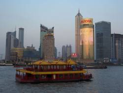
GNSS (all systems) Archives - Page 132 of 151 - Inside GNSS - Global Navigation Satellite Systems Engineering, Policy, and Design

GNSS (all systems)

Spirent Launches TestDrive-GNSS Automation Software

Spirent Communications has announced the launch of its new automation and reporting tool, TestDrive-GNSS for SimGEN- and SimREPLAYplus-controlled GNSS test systems. TestDrive-GNSS automates the testing process to significantly reduce overhead costs and testing times associated with characterization of GNSS devices.

Read More >

By Inside GNSS
November 21, 2011

GNSS Hotspots | November 2011

One of 12 magnetograms recorded at Greenwich Observatory during the Great Geomagnetic Storm of 1859
1996 soccer game in the Midwest, (Rick Dikeman image)
Nouméa ground station after the flood
A pencil and a coffee cup show the size of NASA’s teeny tiny PhoneSat
Bonus Hotspot: Naro Tartaruga AUV
Pacific lamprey spawning (photo by Jeremy Monroe, Fresh Waters Illustrated)
“Return of the Bucentaurn to the Molo on Ascension Day”, by (Giovanni Antonio Canal) Canaletto
The U.S. Naval Observatory Alternate Master Clock at 2nd Space Operations Squadron, Schriever AFB in Colorado. This photo was taken in January, 2006 during the addition of a leap second. The USNO master clocks control GPS timing. They are accurate to within one second every 20 million years (Satellites are so picky! Humans, on the other hand, just want to know if we’re too late for lunch) USAF photo by A1C Jason Ridder.
Detail of Compass/ BeiDou2 system diagram
Hotspot 6: Beluga A300 600ST

1. Portland, Oregon and Los Angeles, California USA
TWINS!

Read More >

By Inside GNSS

Making Virtual Solid

FIGURES 1 & 2: True3D Volumetric HUD components and operation (left), Comparison of True3D HUD user view with other types of nav aids (right)

Return to main article: "True3D HUD Wins Global SatNav Competition"

Many technologies are created before their best applications are even thought about. This leads to a business phenomenon known as “technology push” in contrast to “consumer pull.” The True3D Volumetric HUD technology did not share this path.

Read More >

By Inside GNSS
[uam_ad id="183541"]
November 16, 2011

Network RTK and Reference Station Configuration

Q: What effect does network size have on NRTK positioning?

A: Network real-time kinematic (NRTK) positioning is nowadays a very common practice, not only in academia but also in the professional world. In the last 10 years, several networks of continuous operating reference stations (CORSs) were created to support users. These networks offer real-time services for NRTK positioning, providing centimeter-level positioning accuracy with an average distance of 25–35 kilometers between the reference stations.

Read More >

By Inside GNSS

Staying In Lane

Next-generation car navigation may well require the ability to identify the lane in which a vehicle is operating on a motorway. This could support advanced driver assistance in general as well as the observation and study of driver behavior and traffic flow. Such road vehicle applications call for sub-meter positioning accuracy, often in real-time — all this preferably at low-cost.

Read More >

By Inside GNSS
[uam_ad id="183541"]

True3D HUD Wins Global SatNav Competition

Mike Rowe, host of the Discovery Channel series Dirty Jobs, gets behind the wheel with MVSC’s HUD system at the Makers Faire in San Mateo, California. MVSC CEO Chris Grabowski sits in the passenger seat; CTO Tom Zamojdo is in straw hat. Photo by Valerie Hall.

A San Francisco Bay Area company — Making Virtual Solid–California (MVSC), which snared a trio of awards in a global GNSS competition for its novel approach to driver assistance, is still in early phases of development.

The origins of the company, however, go back more than 40 years to the Cold War era when its principals, Chris Grabowski and Tom Zamojdo, were studying physics and theoretical mathematics at the University of Warsaw, Poland.

But more about that later — first, the news.

Read More >

By Inside GNSS
November 13, 2011

2012 East Coast Seminars: NavtechGPS

NavtechGPS will offer its 2012 East Coast GNSS technical seminars at the Doubletree Annapolis in Maryland, USA from June 18 through June 22.

The seminar instructors are Penny Axelrad, John Betz, Chris Hegarty, Alan Pue and James Sennott.

For more than 25 years, NavtechGPS has provided GPS/GNSS applications solutions for military and research customers, with product choices from more than 30 manufacturers, and has organized basic and advanced GNSS seminars for engineers and technical professionals all over the United States.

Read More >

By Inside GNSS

2012 West Coast Seminars: NavtechGPS

NavtechGPS will offer its 2012 West Coast GNSS technical seminars at the Doubletree Mission Valley Hotel in San Diego, California from March 26 through March 30.

The seminar instructors are Penny Axelrad, John Betz, Chris Hegarty, Alan Pue and James Sennott.

Read More >

By Inside GNSS
November 10, 2011

Munich Satellite Navigation Summit 2012

A Residenz courtyard, Munich

The 2012 Munich Satellite Navigation Summit will take place at the Residenz Munchen in Germany from March 13 to 15. This year’s opening plenary theme is "GNSS and Security."

This year marks the 10th anniversary of this key European and international event on the policies and direction of the global navigation satellite systems.

The program has been posted online.

Planned 2012 discussions include:

Read More >

By Inside GNSS
IGM_e-news_subscribe