Column

LightSquared: Who Pays for GPS Receiver Fixes Yet to be Devised?

With more testing on the horizon and a potentially alarming homeland security report about to be released, LightSquared’s efforts to begin work on its proposed wireless broadband service are stuck in the procedural mud.

The delays, which are never good for a commercial company, are piling up just as the firm’s coffers are thinning and need to be replenished with a new round of fund raising.

Read More >

By Dee Ann Divis
September 13, 2011

Worst GPS President Ever?

First, let’s review the record of presidential leadership in GPS.

In 1983, following the shooting down of an errant Korean airliner over Soviet airspace, President Ronald Reagan ordered the U.S. Air Force to make GPS available for civilian use so that such navigational errors could be avoided in the future.

George H. W. Bush was commander in chief in 1991 during the first Persian Gulf when GPS helped coalition troops throw the so-called “left hook” by navigating through the desert around entrenched Iraqi troops in Kuwait.

Read More >

By Inside GNSS
[uam_ad id="183541"]

The Differences in Differencing

Equation 1

Q: How does measurement differencing affect my computed position?

A: The short answer is, “That depends.”

Standalone, or undifferenced, measurements obviously produce the poorest positioning performance. However, how we proceed from this most basic data processing approach may affect the computed solution. In this article, we look at the details of why this occurs.

Read More >

By Inside GNSS
July 26, 2011

The Fire Next Time

What have we learned from the LightSquared fiasco?

Aside from the fact that someone gambling with other people’s money, with friends in high places benefiting from his largesse, can make the law stand on its head and our hair stand on end.

But then, we already knew that.

Just because the forces behind the broadband cellular company, Philip Falcone and Harbinger Investments, made their money by betting against the housing bubble doesn’t take away from the fact that they represent the same crew who helped take down the world economy in 2007.

Read More >

By Inside GNSS
[uam_ad id="183541"]

GNSS-Based Attitude Determination

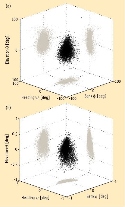
FIGURE 1: Heading, bank and elevation angles of an actual platform carrying two perpendicular two meter-long baselines. The attitude solutions are shown for both the derived, or float, measurements (top), as well as the carrier phase-based, or fixed, measurements obtained after having correctly resolved the integer ambiguities (bottom). Precision differs between the methods by two orders of magnitude. Gray dots represent the two-dimensional projections on each of the three coordinate planes.

Working Papers explore the technical and scientific themes that underpin GNSS programs and applications. This regular column is coordinated by Prof. Dr.-Ing. Günter Hein, head of Europe’s Galileo Operations and Evolution.

Read More >

By Inside GNSS

What is a virtual reference station and how does it work?

Q: What is a virtual reference station and how does it work?

A: To reach centimeter-level — or even better — accuracy of positioning typically requires use of precise dual-frequency carrier phase observations. Furthermore, these observations are usually processed using a differential GNSS (DGNSS) algorithm, such as real time kinematic (RTK) or post-processing (PP). Regardless of the specific differential algorithm, however, implicit in the process is an assumption that the quality of the reference station data is consistent with the desired level of positioning accuracy.

Read More >

By Inside GNSS
May 24, 2011

A Target — Possibly Moving

Up here in the beautiful Pacific Northwest — yes, the sun is shining; hence, my enthusiasm — we have a wealth of wildlife. It goes nicely with the splendid landscape.

We have birds of all songs and colors. (Migratory Western tanagers passing through right now.) A selection of bears, mountain lions, the occasional wildcat. A surfeit of deer. 

Even buffalo and grey wolves are making their comeback.

Read More >

By Inside GNSS
May 19, 2011

How do you compute relative position using GNSS?

Figure 1

Q: How do you compute relative positions with GNSS?

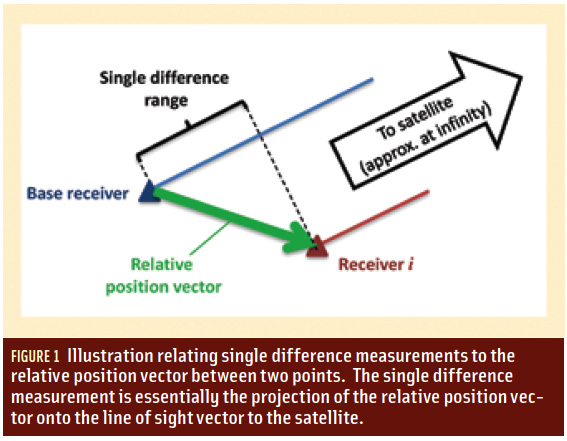
A: GNSS is well recognized as an excellent means of computing position, but many people think that GPS only provides absolute position information. However, GNSS can also provide relative position information. In this column, we will look at some of the details of how this is done.

Read More >

By Inside GNSS

Homeland Security Steps Up to Protect GPS (But Not from LightSquared)

After a long series of fits and starts, the Department of Homeland Security is tackling the issue of interference to the GPS signal. The agency has launched a study to assess the risks to GPS service from a variety of sources — a study that, at least on paper, will lead to a plan to mitigate interference.

Unfortunately, the effort will not directly address the one potential problem consuming the thoughts of the GPS community — widespread receiver overload from the high-powered mobile broadband service proposed by the Virginia firm LightSquared.

Read More >

By Dee Ann Divis
IGM_e-news_subscribe