Survey and Mapping

June 6, 2018

Topcon Positioning Group Releases Data Controller with Advanced Speed and Power Functionality

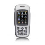
The Topcon Positioning Group today introduced the new T-18 handheld controller designed to drive geopositioning, construction, mapping and vertical construction applications.

The controller includes a 3.7-inch sunlight-readable display with a 1gigihertz processor, 1GB of internal storage, and up to 10 hours of battery life.

“For MAGNET® Field data collection, the T-18 controller offers a durable ergonomic solution with faster processing, a larger screen, better connectivity and longer battery life than previously available comparable systems,” said Ray Kerwin, director of global surveying products.

The T-18 features a 3.5G cellular modem for connectivity with Topcon MAGNET solutions for sending and receiving data to the cloud company account.

“The cellular option makes it easy to communicate with field crews when projects need to be changed or if important data is required back in the office. Additionally, the modem can be used for RTK (real-time kinematic) correction services,” said Kerwin.

Additional key features include standard Bluetooth and Wi-Fi connectivity, as well as an IP65 rating for dust and water protection in demanding job site conditions.

By Inside GNSS
[uam_ad id="183541"]
December 14, 2017

DATAGNSS Launches D302-RTK Cost-Effective, High-Accuracy Handheld RTK Receiver

DATAGNSS, a company specialized in rugged data collector based in Hong Kong, just announced their cost-effective all-in-one handheld RTK receiver, D302-RTK.

D302-RTK is a high accuracy positioning handheld device with rugged design, based on Android OS. It integrates with optimized centimeter-level RTK positioning engine. With an external survey antenna or optional helix antenna, D302-RTK provides up to 2-centimeter positioning accuracy, according to the company. This RTK handheld device supports WiFi/BT/LTE networks.

Read More >

By Inside GNSS
November 27, 2017

Ligado: Business and Network Plan Remain Unclear

A highly anticipated presentation by Ligado Networks to the nation’s leading satellite navigation experts took an unexpected turn when the company said it could not provide essential network information because it was looking to the government for technical direction and its business plans were still in flux.

Read More >

By Dee Ann Divis
[uam_ad id="183541"]

Towards Navigation Safety for Autonomous Cars

There are many good reasons for getting excited about highly automated vehicles, or HAVs, which is the acronym used by the National Highway Traffic Safety Administration (NHTSA). HAVs can make driving more fuel- and time-efficient. They can significantly reduce traffic congestion and emissions by driving a precise speed, minimizing lane changes, and maintaining an exact distance to neighboring cars. They can also increase accessibility and mobility for disabled and elderly persons.

Read More >

By Inside GNSS
August 25, 2017

Commercial UAV EXPO

With unparalleled education and more exhibitors than at any other commercial drone show, Commercial UAV Expo, happening Oct 24-26 in Vegas, is the best choice for professionals who need to keep up-to-date on technology, trends and developments for industrial drone applications.

The commercial UAV event will provide workshops and educational sessions on a variety of topics including:

• Surveying & Mapping

• Civil Infrastructure

• Mining & Aggregates

• Construction

Read More >

By Inside GNSS
1 4 5 6 7 8 28
IGM_e-news_subscribe