B: Applications

July 9, 2018

Joint Navigation Conference (JNC)

The Military Division of the Institute of Navigation (ION) will host the 2018 Joint Navigation Conference (JNC 2018) for the Department of Defense and Department of Homeland Security this summer in Long Beach, California. The theme of this year’s conference will be: Positioning, Navigation and Timing Technologies: The Foundation for Military Ops and Homeland Security.

Read More >

By Inside GNSS
July 5, 2018

Securing PNT Workshop Looks at GNSS Back-up Options

With eyes on a future where reliable GNSS back-ups are in place to protect against both accidental or intentional disruptions of GNSS, three organizations represented on Positioning, Navigation and Timing Technical Group (PNTTG) – Innovate UK Knowledge Transfer Network (KTN), Royal Institute of Navigation (RIN) and The General Lighthouse Authorities – hosted a seminar last month to review user needs and the status of two possible RF back-up options to GNSS mentioned in the London Economics report on the economic impact of a GNSS disruption.

Read More >

By Stan Goff

Atos Launches Compact, Multifunction Satellite Power Testing System

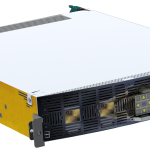
Atos recently announced the launch of ProUST univerSAS (Protection Unit for Satellite Testing), its lightweight, compact satellite power testing system designed to improve high-volume satellite production by increasing the speed and efficiency of testing, while maintaining the industry’s quality and safety standards.

ProUST univerSAS is the first product following Atos’ recent acquisition of Siemens Convergence Creators (CVC), resulting in reinforced capabilities in the space market. The product is the latest addition toAtos’ integrated suite of electrical satellite testing solutions – EGSE (Electrical Ground Support Equipment) – which ensures that satellites’ systems are in optimum condition in order to work flawlessly during their entire lifespan in-orbit.

The ProUST univerSAS is a compact and power-dense satellite power testing system, said to delivermore than 16kW of power in just 2HU (~10cm). It is unique in that it can test numerous power configurations (Solar Array Simulation, Battery Simulation and Load Simulation) in one single device.

New Space challenges require a new kind of equipment

This system supports manufacturers to meet today’s ambitious high-volume production loads and adapt from traditional, mostly manual assembly, towards a more efficient manufacturing process. Its light weight, compact size, versatility and portability enables manufacturers to save on space and costs and improve on efficiency for faster development and testing cycles, using one single device.

“The introduction of ProUST univerSAS marks a new era in satellite power test system design. We are bringing together unprecedented power handling capability and versatility with assembly-line efficiency for the space industry. The system’s mobility facilitates flexible deployment in state-of-the-art production facilities around the globe, making it a natural building block of today’s and tomorrow’s satellite manufacturing installations,”Hans-Martin Steiner, CTO Space & Avionics at Atos, said in a press release.

Atos is experienced in providing effective solutions to the space industry, including those used in ground mission and control centers. It is also a pioneer in the development of Earth Observation Data exploitation platforms and is fostering innovation with numerous R&D projects.

By Inside GNSS
[uam_ad id="183541"]
June 29, 2018

Inertial Sense Partners with DataTribe to Expand Autonomous Navigation

Inertial Sense announced last week that it has closed a $2 million round of seed funding led by DataTribe and supported by Atomic Ventures. Inertial Sense, a manufacturer of high-performance precision GPS-Inertial Navigation Systems, will use the funds to accelerate their market-leading position and advanced development of additional micro-navigation solutions and 3-D motion sensors.

Read More >

By Inside GNSS
[uam_ad id="183541"]
June 25, 2018

GSA’s Cospas-Sarsat Meeting Addresses Progress of Search and Rescue Systems

The Cospas-Sarsat MEOSAR (Medium-Altitude Earth Orbit Search and Rescue) system has been in the news quite a bit of late, and with good reason. As the technology has evolved, so too has the ability to improve search and rescue operations which save lives.

The cover story for the current issue of Inside GNSS is dedicated to the Cospas-Sarsat MEOSAR system and its role as a solution to support the ICAO GADSS Autonomous Distress Tracking recommendation.

Read More >

By Inside GNSS
June 21, 2018

FAA Now Has Improved GPS Coverage Across U.S. as GEO 5 joins WAAS

The Federal Aviation Administration’s Geosynchronous Earth Orbiting 5 Wide Area Augmentation System (WAAS) navigation payload, developed by Raytheon’s Intelligence, Information and Services business, is now operational and fully integrated into the WAAS network. The GEO 5 payload joins two others already on orbit in correcting GPS satellite signal ionospheric disturbances, timing issues, and minor orbit adjustments, giving users increased coverage, improved accuracy, and better reliability.

Read More >

By Inside GNSS
June 20, 2018

GPS IIIF: The Air Force Decides to Stick With Lockheed

Over at least half a dozen years the GPS III Follow On program has taken a number of dramatic turns only to wind up, in true soap opera fashion, with the same leading characters headed to the altar.

At the end of the latest episode, the field of suitors for the multi-billion-dollar GPS IIIF contract narrowed suddenly in April when two of the three corporate hopefuls abruptly left the field.

Read More >

By Dee Ann Divis
June 19, 2018

Naval Research Laboratory Marks 60 Years in Space with Vanguard

Just more than 60 years ago the U.S Naval Research Laboratory (NRL) launched what has become the longest remaining man-made object in space.

Launched in March 1958, Vanguard I, a component of the Vanguard Project, is a small aluminum sphere (16.5 centimeters in diameter) that was designed to partake in the International Geophysical Year (IGY) — a series of coordinated observations of various geophysical phenomena during solar maximum, spanning July 1957 through December 1958.

Read More >

By Inside GNSS
IGM_e-news_subscribe