
July 24, 2024
The ABCs of PNT
A look at how far we’ve come, where we are today and where we’re going in the effort to protect PNT and critical infrastructure when GNSS services aren’t available.
By Dawn M.K. Zoldi (Colonel, USAF, Ret.)Global Navigation Satellite Systems Engineering, Policy, and Design
A look at how far we’ve come, where we are today and where we’re going in the effort to protect PNT and critical infrastructure when GNSS services aren’t available.
By Dawn M.K. Zoldi (Colonel, USAF, Ret.)
A: Receiver Autonomous Integrity Monitoring (RAIM) and Advanced RAIM (ARAIM; known more generally as Solution Separation RAIM, or SS-RAIM) were originally designed to detect, alert and (where possible) exclude faulty measurements caused by Signal-in-Space (SIS) failures.
By Sam Pullen
By Karen Van Dyke, Director, Positioning, Navigation, and Timing (PNT) and Spectrum Management in the U.S. Department of Transportation Office of the Assistant Secretary for Research and Technology (OST-R)
By Inside GNSS
GPS technology developer oneNav has announced the successful results of a test of its technology’s resilience to widespread GPS interference. The tests took place in and around Haifa, Israel, and examined the performance of its L5-direct GPS receiver against the performance of GPS receivers in leading smartphone and smartwatch brands.
By Inside GNSS
The US Army released a Request for White Papers (RfWP) to develop new CMFF prototypes. CMFF—C5ISR Modular Open Suite of Standards (CMOSS) Mounted Form Factor—is the Army’s effort to easily and rapidly equip ground vehicles and aviation platforms with capabilities like positioning, navigation, and timing (PNT) and electronic warfare (EW), through capability cards plugged into a common chassis.
By Inside GNSS
Inertial Labs has announced the integration of its RESEPI LIDAR solution into the high-performance unmanned aerial vehicles (UAVs) manufactured by ideaForge. This collaboration aims to advance UAV-based LIDAR mapping, providing industries with an enhanced, highly accurate, and reliable solution.
By Inside GNSS
Swift Navigation and Bad Elf have announced a partnership to deliver a complete, turnkey solution for high volume and high precision GIS data collection. GIS data enables workers across industries to create precise digital maps (showing the location of buried infrastructure, for example) that improve worker safety and efficiency in construction, utilities, and environmental management.
By Inside GNSS
Designed in Boulder, Colorado, USA, the SparkFun RTK EVK (Evaluation Kit) provides a development platform for fixed or mobile high-precision positioning and navigation needs. The RTK EVK comes with a range of options for prototyping: L1 + L2 RTK GNSS, with L-Band correction built-in if needed, running on an agile processor.
By Inside GNSS
The European Space Agency’s Navigation Innovation and Support Program Advisory Committee (NAVAC) has released a new white paper outlining its vision for the evolution of positioning, navigation, and timing (PNT) technology, applications, and services until 2035.
By Peter Gutierrez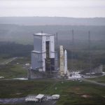
Ariane 6’s inaugural rocket launch took place from Europe’s Spaceport in French Guiana at 16:00 local time on 9 July. It has taken over from Ariane 5, featuring a modular design that can launch missions from low-Earth orbit and into deep space. Galileo Second Generation (G2) satellites are projected to join the constellation in 2026 with the Ariane 6 launcher. G2 satellites will use electric propulsion and host a more powerful navigation antenna, better atomic clocks and fully digital payloads.
By Inside GNSS
Today’s air transportation management depends on a complex systems of systems, operating under stringent reliability and safety requirements. The use of satellite communications, GNSS and other PNT services represents a range of vulnerabilities to inadvertent as well as intentional hostile action.
By Inside GNSS
The European Union Aviation Safety Agency (EASA) has released a revised Safety Information Bulletin (SIB) addressing the growing issue of Global Navigation Satellite System (GNSS) outages and disruptions. This updated advisory, SIB No. 2022-02R3, highlights the increasing sophistication and impact of GNSS jamming and spoofing, which have become significant concerns for aviation safety.
By Inside GNSS
The European Defence Fund (EDF) and the Ministries of Defence of Estonia and Finland have awarded a €6 million investment to Project BadB, a consortium led by Estonian defence technology company KrattWorks. The project focuses on developing advanced navigation solutions for land and aerial vehicles that do not rely on global navigation satellite systems (GNSS).
By Inside GNSS