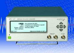
B: Applications

Real-time Kinematic with Multiple Reference Stations

Multiple reference station RTK (real-time kinematic) is a complex, yet natural extension of single reference station RTK. Single reference station RTK actively and dynamically measures GNSS measurement errors, most notably satellite orbit, troposphere, and ionosphere errors.

Multiple reference station RTK (real-time kinematic) is a complex, yet natural extension of single reference station RTK. Single reference station RTK actively and dynamically measures GNSS measurement errors, most notably satellite orbit, troposphere, and ionosphere errors.

These measurement errors are characterized by their spatial correlation. To this end, in single reference station RTK, the errors are assumed to be constant everywhere around the reference station. In reality however, because the errors are not constant, the quality of these error estimates degrade as a function of distance and can reach an unacceptable level for ambiguity resolution after tens of kilometers.

One approach to ensure an acceptable level of measurement error over a wide geographic region is to deploy many reference stations, each operating independently. Once this infrastructure is in place, users select the reference station that will provide them with the greatest reduction of measurement errors and apply the corresponding corrections in the traditional single reference station RTK approach.

Unfortunately, the decision of which reference station to use can be problematic especially when the user is located between reference stations with nearly equally spacing. The estimated measurement errors at each of the reference stations may be different but the user is forced to discretely choose one or the other.

The solution to this problem is multiple reference station RTK. Instead of choosing the solution from one reference station or another, the multiple reference station solution allows users to combine the estimated measurement errors at each of the reference stations and smoothly transition from the errors at one reference station to another.

The multiple reference station solution is not only better because of the ease of use when transitioning between reference stations but also because the smooth combined solution is more likely to represent the user-observed measurement errors. This provides an even further reduction of user measurement errors, relative to the single reference station case.
. . .
The main advantage of multiple reference station RTK stems from the improved user performance. However, the improvement in performance can also be analyzed in an opposite manner, namely, as a way to increase the spacing between reference stations while still achieving the same level of performance. The performance improvement depends on many factors, including the variability of the measurement errors in the region and the ability to successfully resolve network ambiguities.

Multiple reference station RTK is more robust against station outages because a network solution can still be calculated even if individual reference station data is missing. However, due to the current trend of sparse network station spacing, the absence of any individual reference station would likely cause pockets within the network with less than desirable performance. Even under these conditions, the network solution is still more likely to provide a solution better than that from a single reference station.

This improvement comes at a cost of increased complexity and infrastructure. The data from all of the network reference stations must be collected in a central location for processing and then redistributed to network users. The cost of maintaining a processing center and data communication links for each reference station may be significant, depending on the number of reference stations and the country and region in which the network is located.

(For the rest of Paul Alves’ answer to this question, including figures and graphs, please download the complete article using the pdf link above.)

GNSS Solutions is a regular column featuring questions and answers about technical aspects of GNSS. Readers are invited to send their questions to the columnist, Prof. Mark Petovello, Department of Geomatics Engineering, University of Calgary, who will find experts to answer them.

By
June 17, 2008

New Company, New Time Code Generator

ORCA Technologies’ GS-101

ORCA Technologies LLC, a recent start-up company — but one whose principals come with a long background in GPS timing instrumentation — has introduced the Model GS-101 GPS/IRIG-B Synchronized Time Code Generator (STCG).

Read More >

By Glen Gibbons
June 6, 2008

GNSS Hotspots | June 2008

One of 12 magnetograms recorded at Greenwich Observatory during the Great Geomagnetic Storm of 1859
1996 soccer game in the Midwest, (Rick Dikeman image)
Nouméa ground station after the flood
A pencil and a coffee cup show the size of NASA’s teeny tiny PhoneSat
Bonus Hotspot: Naro Tartaruga AUV
Pacific lamprey spawning (photo by Jeremy Monroe, Fresh Waters Illustrated)
“Return of the Bucentaurn to the Molo on Ascension Day”, by (Giovanni Antonio Canal) Canaletto
The U.S. Naval Observatory Alternate Master Clock at 2nd Space Operations Squadron, Schriever AFB in Colorado. This photo was taken in January, 2006 during the addition of a leap second. The USNO master clocks control GPS timing. They are accurate to within one second every 20 million years (Satellites are so picky! Humans, on the other hand, just want to know if we’re too late for lunch) USAF photo by A1C Jason Ridder.
Detail of Compass/ BeiDou2 system diagram
Hotspot 6: Beluga A300 600ST

1. CANADA AND U.S. FIGHT OVER OREGON – AND GPS IS THERE!
Kingston, Ontario, Canada.
√ The Canadian navy built the Murney Tower when Canada and the U.S. fought over Oregon in 1846. Cruises of this Kingston, Ontario region feature the world’s first wireless GPS-triggered audio tours — in six languages, no less. The UNESCO World Heritage Site features old fortifications guarding the Rideau Canal.

Read More >

By Alan Cameron
[uam_ad id="183541"]
May 27, 2008

Topcon Draws on GNSS Expertise to Build Leadership

Recent leadership appointments at Topcon Positioning Systems (TPS) reflect the company’s efforts to expand its focus from being a vendor of equipment for surveying, civil engineering, and construction to a broad-spectrum provider of positioning solutions drawing heavily on GNSS-based technologies.

Read More >

By Glen Gibbons
May 16, 2008

Lockheed Martin Wins GPS IIIA Contract

A team led by Lockheed Martin Space Systems Company has won U. S. Air Force approval to build the GPS Block IIIA satellites under a contract valued at up to $3.568 billion.

The long-delayed decision was announced May 15. The acquisition covers the first of three sets of Block III satellites currently scheduled to begin launching in 2014.

Read More >

By Glen Gibbons
May 1, 2008

Hemisphere GPS Reports Record Revenues, Profits in First Quarter

Hemisphere GPS has reported US$25.9 million in revenues for the first quarter of 2008, an increase of 56 percent from the year-earlier period (US$16.7 million) and a record for the company.

The company also reported record first quarter net income of $5.8 million, or $0.11, an increase of 169 percent compared to $2.2 million, or $0.05 per share, in the first quarter of 2007.

Read More >

By Glen Gibbons
[uam_ad id="183541"]
April 30, 2008

Lockheed Joins Northrop Grumman OCX Team

As speculated might occur, Lockheed Martin has joined the Northrop Grumman Corporation team competing for the GPS Next Generation Control Segment (OCX) Phase B contract. Lockheed had led its own team in the first round of competition that ended last November.

With Boeing as part of the other prospective OCX team headed by Raytheon Corporation, both companies with experience operating the GPS ground-based infrastructure are playing supporting roles for the contest to build the new control system.

Read More >

By Glen Gibbons
April 28, 2008

Telematics Detroit 2008

 SEE TELEMATICS DETROIT 2009!

Conference and exhibition on automotive, mobile and web-based telematics takes place in The Rock Financial Showplace in Novi, Michigan, USA. It features a Navigation and Location miniconference on May 21 and 22 focusing on new developments and delivery strategies for navigation and location based strategies across industries.

Read More >

By Inside GNSS
April 27, 2008

Galileo’s GIOVE-B Satellite Opens New Era of GNSS Signals

Close up view of the payload fairing of the Soyuz-Fregat launcher carrying ESA’s GIOVE-B satellite, on the launch pad in Baikonur, Kazakhstan, prior to the April 27, 2008, launch. ESA photo by S. Corvaja

A new generation of GNSS signals will become available soon as Europe’s second Galileo In-Orbit Validation Element satellite (GIOVE-B) reached orbit, following successful launch on Sunday (April 27) from the Baikonur cosmodrome in Kazakhstan.

Riding a Soyuz/Fregat launcher, the 500-kilogram (1,100-pound) spacecraft lifted off at 12:16 a.m. Central European Summer Time (CEST). The Fregat upper stage performed a series of maneuvers to reach a circular orbit at an altitude of about 23,200 kilometers inclined at 56 degrees to the equator. The two solar panels that generate electricity to power the spacecraft deployed correctly and were fully operational by 5:28 CEST.

The European space Agency (ESA) operational schedule called for Galileo signals at three L-band frequencies to begin transmitting within seven to eight hours after reaching orbit, according to Giuseppe Viriglio, ESA’s director of telecommunications and navigation.

Read More >

By Glen Gibbons
April 19, 2008

GPS III Satellite Contract: An Undeclared Winner?

GPS III conceptual drawing, The Aerospace Corporation

The Air Force has further delayed the announcement of its decision on who will be the prime contractor for the next block of GPS satellites, IIIA. Earlier reports had set the contract award announcement for early April.

On Wednesday (April 23), Anthony Russo, deputy director of the National Coordination Office for Space-Based Positioning, Navigation, and Timing (PNT), told a European Navigation Conference 2008 in Toulouse, France, that "source selection" has been identified. He added, "I had hoped to announce [the results] at this conference, but the process is not complete yet."

Source selection means that the GPS Wing at the Space and Missile Systems Center (SMC) has completed its
evaluation of the bids on the contract and the preferred provider for the new generation of satellites. The Wing — responsible for overseeing the acquisition of GPS space, ground, and military user equipment — has a presentation ready on the IIIA contract award but is waiting to brief the Air Force decision maker, in this case, apparently Air Force Secretary Michael Wynne.

Read More >

By Glen Gibbons
April 8, 2008

GNSS on the Go–Sensitivity and Performance in Receiver Design

Position tracking is no longer limited to fixed automotive applications or expensive handheld tracking systems.

Consumer demand combined with recent innovations in GNSS technology is making position tracking a must-have feature in a wide range of cost-sensitive applications, including cellular handsets, personal navigation systems, and other consumer electronic devices.

Developing a GNSS position tracking subsystem for consumer electronic devices can appear to be a daunting challenge. Developers must not only keep down costs while maximizing performance and accuracy, they have to do so using RF technology with which they may have little experience.

Sensitivity is the key to accuracy of a GNSS receiver. The signals that a GNSS receiver tries to detect and process are buried in noise; therefore, the task of maintaining signal integrity is a key challenge for many developers.

This article describes how becoming familiar with a few key aspects of RF design can help developers avoid many of the seemingly arbitrary design decisions that can cause position tracking functionality to fail to achieve sufficient accuracy. It also highlights how developers can exploit software-based GNSS baseband architectures to reduce RF subsystem complexity while further increasing sensitivity and positioning accuracy. . .

Conclusion
. . . By understanding that RF sensitivity is the key to accuracy, developers can avoid common design pitfalls that delay time to market and increase system cost.

Additionally, by using the proper components and taking advantage of next-generation innovations such as software-based baseband processing, developers can achieve the best sensitivity and accuracy without having to become RF experts themselves.

(For the complete article, including figures, charts, and images, please download the PDF version at the link above.)
By
April 7, 2008

The Art of ARTUS–A Second-Generation Galileo/GPS Receiver

Creation of new global navigation satellite systems and modernization of existing ones is introducing many new signals across a wide swath of RF spectrum now and in the near future. These developments are accompanied by a growing need to design new GNSS receivers that can work with new signal structures on an increasing number of frequencies.

Europe’s Galileo program has supported a number of activities intended to promote innovations in receiver design, such as prototype Galileo user equipment, reference receivers, and so on.

One such activity is a project named ARTUS (Advanced Receiver Terminal for User Services), 50 percent of which is financed by funds allocated by the Galileo Joint Undertaking (GJU). A consortium of four companies is leading the ARTUS project (see "Acknowledgments" below)

ARTUS supports the development of receiver technologies to aid the research and development activities for Galileo “professional” receivers. These efforts are designed to facilitate the availability of Galileo professional receiver prototypes and antennas at an early stage.

ARTUS provides Galileo/GPS navigation capability. All three Galileo frequencies (L1, E6 and E5a/E5b) are supported as well as the GPS L1, L2 and L5 (L5=E5a) frequencies.

The receiver supports any BPSK (GPS-C/A, Galileo E5a and E5b (sideband tracking), AltBOC (E5ab), Galileo L1-B/C (BOC(1,1)) as well as BOCc(15,2.5) (E1-A / E6-A); GIOVE-A transmits BPSK (E5a/E5b/E6) and BOC(1,1) (E1).

Although the receiver can track the modulations foreseen for the PRS, it cannot generate the corresponding codes. One can, however, do performance measurements using periodic substitute codes.

Although not initially planned, the consortium has decided to also implement the GPS L2 band for commercial reasons. The unit performs the measurements and processes the raw data to provide an RTK solution.

The Artus design will also form the basis for a breadboard development of the next generation RIMS receivers. This development will be conducted in the frame of an ESA contract lead by IFEN with NemeriX and Euro Telematik as subcontractors.

This article describes the design and operation of the second-generation ARTUS receiver with a particular focus on innovations in four key areas: antenna, RF front-end, digital baseband processing, and navigation software.

Although originally intended to focus primary on tracking Galileo and GPS signals, the flexible design of ARTUS also allows it to receive and track signals from the Russian GLONASS system and China’s Beidou.

After discussing the receiver design and operation, we will briefly describe some of the results of testing using combinations of laboratory GNSS signal simulators, signals-in-space, and simulated signals generated in the German Galileo Test Bed (GATE). . .

Conclusion
The ARTUS GNSS receiver described in this article offers a rich flexibility for various configurations of signals on different RF bands. The high performance antenna in conjunction with a flexible RF front-end design offers excellent performance on all currently available GNSS signal bands, including the upcoming Galileo system.

With the availability of up to 120 channels, the receiver is well equipped for future navigation systems; however, it can also be configured in a version with only 20 or 40 channels for tracking the currently available GPS (L1 and L2) alone.

The modular concept, applied even for the firmware of the baseband processor FPGAs, allows easy adaptation of the algorithms developed for the ARTUS receiver or fast implementation of new algorithms. And if the IP protocol is used, any user interface can easily connect — even remotely — to the receiver — whether for navigation or monitoring purposes.

The ARTUS project is now in its qualification phase. Further developments aim for the commercialization of the receiver.

(For the complete article, including figures, charts, and images, please download the PDF version at the link above.)


Acknowledgments

ARTUS was developed in the framework of a GJU 50 percent–funded project, contract GJU/05/2414/CTR/ARTUS. These activities have been taken over by the European GNSS Supervisory Authority (GSA). This support is gratefully acknowledged. IFEN served as the principal contractor for ARTUS.

The consortium members involved in the ARTUS receiver development are ifEN (overall system design and baseband processing), NemeriX (analog RF-front-end), Roke Manor Research (antenna and RF splitter), Leica Geosystems and inPosition (RTK software). In essence the ARTUS design is based on previous receiver developments carried out by IFEN in the frame of the German Galileo Test Bed (GATE).

GATE is being developed on behalf of the DLR (German Aerospace Center, Bonn-Oberkassel) under contract number FKZ 50 NA 0604 with funding by the BMWi (German Federal Ministry of Economics and Technology). DLR kindly gave its permission to publish the preliminary test results.

By
IGM_e-news_subscribe