B: Applications

Modernization Times

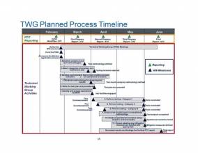
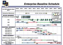
Enterprise Baseline Schedule

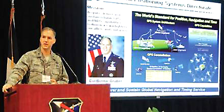
Col. Bernie Gruber, commander of the GPS Directorate since June 2010, works in a busy place.

Through its various incarnations since being established in 1974 — as Joint Program Office, Air Force Wing, and now Directorate — the GPS program at the Space and Missile Systems Center (SMC), Los Angeles Air Force Base, California, has been at the center of the action.

Read More >

By Inside GNSS

Geneq Announced Dual-Frequency RTK GPS, OmniSTAR HP Receivers

Geneq SXBlue IIIL

Geneq Inc., a Montreal, Quebec, Canada, manufacturer, has introduced two new GPS products.

The SXBlue III-L is a compact GPS L1/L2 receiver in the world designed for use with OmniSTAR’s HP service to attain decimeter accuracy worldwide. Targeted at GIS mapping/surveying applications, the receiver measures 14 x 8 x 5.6 centimeters (5.57 x 3.15 x 2.22 inches) and weighs 517 grams (1.14 pounds) including battery.

Read More >

By Inside GNSS
[uam_ad id="183541"]

NavCom Introduces Multi-GNSS SF-3040 Receiver

NavCom Technology’s SF-3040 Receiver

NavCom Technology, Inc., has launched its 66-channel, SF-3040 pole-mount receiver, featuring StarFire/real-time kinematic (RTK) multi-GNSS capabilities and optimized for surveying and mapping applications.

NavCom says its new product provides real-time kinematic (RTK)–level accuracy up to 40 kilometers away from the base station or decimeter-level accuracy anywhere in the world when using the company’s StarFire global satellite-based augmentation system (GSBAS).

Read More >

By Inside GNSS
March 21, 2011

Obama: The Trifecta of Bad Timing on Technology Policies

Talk about your bad timing.

The outcome of the LightSquared/GPS controversy threatens to make President Obama a three-time loser in technology policy matters.

In March 2010, his administration proposed to open for drilling for oil and natural gas extensive expanses along the Atlantic coast, in the eastern Gulf of Mexico, and off the north coast of Alaska, many of those areas for the first time. Less than a month later the Deepwater Horizon oil well explosion unleashed the largest accidental marine oil spill in the history of the petroleum industry.

Read More >

By Inside GNSS
[uam_ad id="183541"]

Trimble to Acquire Fugro’s OmniSTAR DGPS Service

Omnistar DGPS world map

Trimble announced on March 16 that it has entered into a definitive agreement to acquire certain assets related to the OmniSTAR GNSS signal corrections business from Fugro N.V.

The acquisition is expected to significantly expand Trimble’s worldwide ability to provide correction services for a broad range of land-based applications in addition to OmniSTAR’s current focus in agriculture. Fugro’s offshore marine business is unaffected.

Read More >

By Inside GNSS
March 15, 2011

Lockheed’s GPS III Team completes Key Flight Software Milestone

GPS III satellite. Lockheed Martin illustration

Lockheed Martin announced today (March 15, 2011) that the team it leads in developing the U.S. Air Force’s next-generation GPS III satellites has successfully completed the program’s first major flight-software integration milestone at the company’s software integration laboratory in Newtown, Pennsylvania.

Read More >

By Inside GNSS
March 14, 2011

Integer Aperture Estimation

For the complete story, including figures, graphs, and images, please download the PDF of the article, above.

Integer carrier-phase ambiguity resolution is the key to fast and high-precision GNSS positioning and navigation. It is the process of resolving the unknown cycle ambiguities of the carrier-phase data as integers. Once this has been done successfully, the very precise carrier-phase data will act as pseudorange data, thus making very precise positioning and navigation possible.

Read More >

By Inside GNSS
March 12, 2011

Registration opens for 2011 GPS Partnership Council Meeting at Los Angeles AFB

A Coast Guard search and rescue helicopter demonstrates the use of GPS technology at a previous GPS Partnership Council meeting. (Photo: Joe Juarez)

Registration is now open for the 2011 GPS Partnership Council meeting on Tuesday, May 3 and Wednesday, May 4 at the Space and Missile Systems Center (SMC) at Los Angeles Air Force Base in El Segundo, California. 

These military and industry networking meetings, now in their 11th year, are sponsored by the Los Angeles chapter of AFCEA (Armed Forces Communications Electronics Association) and the USAF GPS Directorate, formerly the GPS Wing. 

Read More >

By Inside GNSS
IGM_e-news_subscribe